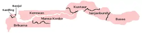
Local government areas of the Gambia
The Gambia is divided into eight local government areas. These are divided into 43 districts.
| Name | Area (km2) | Population Census 2003 | Population Census 2013 (provisional) | Capital | Number of Districts |
|---|---|---|---|---|---|
| Banjul (Capital City) | 12.2 | 35,061 | 31,301 | Banjul | 3 |
| Kanifing | 75.6 | 322,735 | 382,096 | Kanifing | 1 |
| Brikama (formerly Western) |
1,764.3 | 389,594 | 699,704 | Brikama | 9 |
| Mansa Konko (formerly Lower River) |
1,628.0 | 72,167 | 82,381 | Mansa Konko | 6 |
| Kerewan (formerly North Bank) |
2,255.5 | 172,835 | 221,054 | Kerewan | 7 |
| Kuntaur (formerly the western half of Central River Division) |
1,466.5 | 78,491 | 99,108 | Kuntaur | 5 |
| Janjanbureh (formerly the eastern half of Central River Division) |
1,427.8 | 107,212 | 126,910 | Janjanbureh | 5 |
| Basse (formerly Upper River) |
2,069.5 | 182,586 | 239,916 | Basse Santa Su | 7 |
| Total Gambia | 10,689 | 1,360,681 | 1,882,450 | Banjul | 43 |
This article is issued from Wikipedia. The text is licensed under Creative Commons - Attribution - Sharealike. Additional terms may apply for the media files.