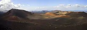
Lanzarote
Lanzarote is one of the Canary Islands.
Geography and Climate
Lanzarote is one of the two islands in the east of the Canary Islands. It is located 100 km west of the Western African coast line and 11 km north of the neighbouring island Fuerteventura. Its dimensions are from east to west coast 16.5 km, from north to south 60 km. The island was created by volcano eruptions. There is only limited natural vegetation on the island. About 130,000 people live on Lanzarote. The largest town on the island is Arrecife.
| Climate data for Lanzarote Airport (1981-2010) | |||||||||||||
|---|---|---|---|---|---|---|---|---|---|---|---|---|---|
| Month | Jan | Feb | Mar | Apr | May | Jun | Jul | Aug | Sep | Oct | Nov | Dec | Year |
| Record high °C (°F) | 27.9 (82.2) |
29.0 (84.2) |
32.7 (90.9) |
36.3 (97.3) |
42.6 (108.7) |
40.7 (105.3) |
42.9 (109.2) |
43.6 (110.5) |
40.5 (104.9) |
36.0 (96.8) |
34.2 (93.6) |
27.5 (81.5) |
43.6 (110.5) |
| Average high °C (°F) | 20.7 (69.3) |
21.3 (70.3) |
22.9 (73.2) |
23.5 (74.3) |
24.6 (76.3) |
26.3 (79.3) |
28.2 (82.8) |
29.1 (84.4) |
28.6 (83.5) |
26.7 (80.1) |
24.2 (75.6) |
21.8 (71.2) |
24.8 (76.6) |
| Daily mean °C (°F) | 17.4 (63.3) |
17.9 (64.2) |
19.0 (66.2) |
19.6 (67.3) |
20.8 (69.4) |
22.6 (72.7) |
24.3 (75.7) |
25.2 (77.4) |
24.7 (76.5) |
23.0 (73.4) |
20.7 (69.3) |
18.6 (65.5) |
21.1 (70.0) |
| Average low °C (°F) | 14.0 (57.2) |
14.3 (57.7) |
15.0 (59.0) |
15.7 (60.3) |
16.8 (62.2) |
18.8 (65.8) |
20.4 (68.7) |
21.2 (70.2) |
20.8 (69.4) |
19.4 (66.9) |
17.2 (63.0) |
15.4 (59.7) |
17.4 (63.3) |
| Record low °C (°F) | 8.0 (46.4) |
9.0 (48.2) |
8.3 (46.9) |
9.5 (49.1) |
11.5 (52.7) |
12.4 (54.3) |
15.4 (59.7) |
16.6 (61.9) |
15.5 (59.9) |
12.0 (53.6) |
10.9 (51.6) |
9.0 (48.2) |
8.0 (46.4) |
| Average rainfall mm (inches) | 16.5 (0.65) |
18.2 (0.72) |
12.5 (0.49) |
5.2 (0.20) |
1.5 (0.06) |
0.1 (0.00) |
0.0 (0.0) |
0.5 (0.02) |
2.2 (0.09) |
9.9 (0.39) |
14.7 (0.58) |
29.3 (1.15) |
110.6 (4.35) |
| Average rainy days (≥ 1.0 mm) | 3 | 3 | 2 | 1 | 0 | 0 | 0 | 0 | 0 | 2 | 3 | 4 | 18 |
| Mean monthly sunshine hours | 203 | 201 | 241 | 255 | 297 | 292 | 308 | 295 | 248 | 235 | 207 | 196 | 2,978 |
| Source: Agencia Estatal de Meteorología[1] | |||||||||||||
Economy
Lanzarote has one international airport at Arreceife (airport code ACE). Lanzarote's economy is mainly supported by tourism. Many tourist come to the island for sunbathing, swimming, windsurfing, walking or snorkeling.
There are a few agricultural producers on the island, and in particular there are some vineyards producing local wines.
Gallery

 Jardín de Cactus
 Cueva de los Verdes
 El Golfo


 Salinas del Janubio
 La Geria
 La Graciosa / Mirador Del Rio
 Playa Blanca