La Guajira Department
La Guajira is a department of Colombia. Its capital is Riohacha.
La Guajira Department | |
|---|---|
 Flag  Coat of arms | |
| Anthem: Himno de La Guajira. | |
.svg.png.webp) La Guajira shown in red | |
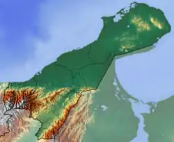 Topography of the department | |
| Coordinates: 11°33′N 72°54′W | |
| Country | |
| Region | Caribbean Region |
| Established | July 1, 1965 |
| Capital | Riohacha |
| Area | |
| • Total | 20,848 km2 (8,049 sq mi) |
| Population (2018)[1] | |
| • Total | 880,560 |
| • Density | 42/km2 (110/sq mi) |
| Time zone | UTC-05 |
| ISO 3166 code | CO-LAG |
| Municipalities | 15 |
| Website | www.laguajira.gov.co/ |
It covers most of the Guajira Peninsula in the northeast region of the country. La Guajira is on the Caribbean Sea and bordering Venezuela.
Municipalities
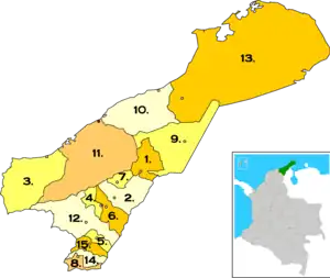
Municipalities of La Guajira Department. Municipality and city of Riohacha highlighted in dark gray and red respectively.
 Albania
 Barrancas
 Dibulla
.svg.png.webp) Distracción
Distracción El Molino
 Fonseca
.svg.png.webp) Hatonuevo
Hatonuevo La Jagua del Pilar
 Maicao
 Manaure
 Riohacha
 San Juan del Cesar
.svg.png.webp) Uribia
Uribia.svg.png.webp) Urumita
Urumita Villanueva
References
- "Censo Nacional de Población y Vivienda 2018". Departamento Administrativo Nacional de Estadística – DANE (in Spanish). Retrieved 25 October 2019.
Wikimedia Commons has media related to La Guajira Department.
This article is issued from Wikipedia. The text is licensed under Creative Commons - Attribution - Sharealike. Additional terms may apply for the media files.