Imbabura Province
Imbabura (Spanish pronunciation: [imbaˈβuɾa]) is a province located in the Andes of northern Ecuador. The capital is Ibarra. The people of the province speak Spanish and the Imbaburan Quechua language.
Imbabura | |
|---|---|
Province | |
| Province of Imbabura | |
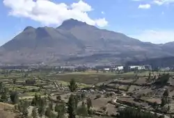 Mount Imbabura from south-east. | |
 Flag | |
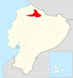 Imbabura Province in Ecuador | |
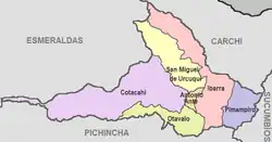 Cantons of Imbabura Province | |
| Country | |
| Capital | Ibarra |
| Government | |
| • Provincial Prefect | Diego García |
| Area | |
| • Total | 4,587.51 km2 (1,771.25 sq mi) |
| Population (2010 census) | |
| • Total | 398,244 |
| • Density | 87/km2 (220/sq mi) |
| Time zone | ECT |
| Vehicle registration | I |
| HDI (2017) | 0.747[1] high · 7th |
The summit of Cotacachi Volcano at an elevation of 4,944 metres (16,220 ft) is 15 kilometres (9.3 mi) north-east of the town of Cotacachi.
Cantons
The province is divided into six cantons. The following table lists each with its population at the 2010 census, its area in square kilometres (km²), and the name of the capital.[2]
| Canton | Pop. (2010) | Area (km²) | Seat/Capital |
|---|---|---|---|
| Antonio Ante | 43,518 | 81 | Atuntaqui |
| Cotacachi | 40,036 | 1,726 | Cotacachi |
| Ibarra | 181,175 | 1,093 | Ibarra |
| Otavalo | 104,874 | 500 | Otavalo |
| Pimampiro | 12,970 | 437 | Pimampiro |
| San Miguel de Urcuquí | 15,671 | 779 | Urcuquí |
References
- Villalba, Juan. "Human Development Index in Ecuador". Scribd (in Spanish). Retrieved 2019-02-05.
- Cantons of Ecuador. Statoids.com. Retrieved 4 November 2009.
This article is issued from Wikipedia. The text is licensed under Creative Commons - Attribution - Sharealike. Additional terms may apply for the media files.