Helmand River
The Helmand River (also spelled Helmend, Helmund, Hirmand; Pashto/Persian: هیرمند, هلمند Hīrmand, Helmand, Greek: Ἐτύμανδρος (Etýmandros), Latin: Erymandrus) is the longest river in Afghanistan.[1] The name means "dammed, having a dam". Helmand Province is named after the river.
| Helmand River | |
|---|---|
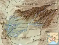 Map of the Helmand River drainage basin | |
 Map of the Helmand River drainage basin | |
| Location | |
| Physical characteristics | |
| Source | |
| - location | Hindu Kush mountains |
| Mouth | |
| - location | Lake Hamun |
| Length | 1,150 km (710 mi) |
| Basin size | Sistan Basin |
| Basin features | |
| Tributaries | |
| - left | Arghandab River |
| - right | Khash River Chagay River |
The Helmand river stretches for 1,150 km (710 mi). It rises in the Hindu Kush mountains, about 80 km (50 mi) west of Kabul (34°34′N 68°33′E), passing north of the Unai Pass. It crosses south-west through the desert of Dashti Margo, to the Seistan marshes and the Hamun-i-Helmand lake region around Zabol at the Afghan-Iranian border (31°9′N 61°33′E).
References
- "History of Environmental Change in the Sistan Basin 1976 - 2005" (PDF). Archived from the original (PDF) on 2007-08-07. Retrieved 2007-07-20.
- Various authors. "HELMAND RIVER". Encyclopædia Iranica (Online ed.). United States: Columbia University.
- Frye, Richard N. (1963). The Heritage of Persia. World Publishing company, Cleveland, Ohio. Mentor Book edition, 1966.
- Toynbee, Arnold J. (1961). Between Oxus and Jumna. London. Oxford University Press.
- Vogelsang, W. (1985). "Early historical Arachosia in South-east Afghanistan; Meeting-place between East and West." Iranica antiqua, 20 (1985), pp. 55–99.
This article is issued from Wikipedia. The text is licensed under Creative Commons - Attribution - Sharealike. Additional terms may apply for the media files.