Hartsfield–Jackson Atlanta International Airport
Hartsfield–Jackson Atlanta International Airport (IATA: ATL, ICAO: KATL, FAA LID: ATL), also known as Atlanta Airport, Hartsfield Airport, and Hartsfield–Jackson, is a public airport in Atlanta, Georgia. It is the world's busiest airport by number of passengers and number of landings and take-offs since 2005. It serves 89 million passengers per year.[2] The airport is the main hub of AirTran Airways, Delta Air Lines, and ExpressJet. The Delta hub is the world's largest airline hub. Delta Air Lines flew most (59%) of passengers from the airport in February 2011.[3] The airport has 199 gates. It has both domestic and international gates.[4]
Hartsfield–Jackson Atlanta International Airport | |||||||||||||||||||||||||||
|---|---|---|---|---|---|---|---|---|---|---|---|---|---|---|---|---|---|---|---|---|---|---|---|---|---|---|---|
_(2).jpg.webp) | |||||||||||||||||||||||||||
| Summary | |||||||||||||||||||||||||||
| Airport type | Public | ||||||||||||||||||||||||||
| Owner | City of Atlanta | ||||||||||||||||||||||||||
| Operator | Atlanta Department of Aviation | ||||||||||||||||||||||||||
| Serves | Atlanta, Georgia, U.S. | ||||||||||||||||||||||||||
| Location | Unincorporated areas of Fulton and Clayton counties; also Atlanta, College Park, and Hapeville, Georgia | ||||||||||||||||||||||||||
| Hub for | |||||||||||||||||||||||||||
| Focus city for | |||||||||||||||||||||||||||
| Elevation AMSL | 1,026 ft / 313 m | ||||||||||||||||||||||||||
| Coordinates | 33°38′12″N 084°25′41″W | ||||||||||||||||||||||||||
| Website | www.atl.com | ||||||||||||||||||||||||||
| Maps | |||||||||||||||||||||||||||
 FAA diagram | |||||||||||||||||||||||||||
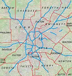 ATL Location of airport in Metro Atlanta  ATL ATL (Georgia)  ATL ATL (the United States)  ATL ATL (North America) | |||||||||||||||||||||||||||
| Runways | |||||||||||||||||||||||||||
| |||||||||||||||||||||||||||
| Helipads | |||||||||||||||||||||||||||
| |||||||||||||||||||||||||||
| Statistics (2018) | |||||||||||||||||||||||||||
| |||||||||||||||||||||||||||
Overview
Hartsfield–Jackson was still the world's busiest airport in 2010. It had an average of 243,000 passengers each day. It also had a total of 950,119 flights. Many of the flights are flights inside the United States. Atlanta is a major hub for travel throughout the Southeastern United States.
Hartsfield–Jackson International Airport has international service to North America, South America, Central America, Europe, Asia, and Africa. The airport is located mostly in unincorporated areas in Fulton and Clayton counties. The city limits of Atlanta,[5] College Park,[6] and Hapeville end at the airport grounds.[7]
Hartsfield-Jackson Atlanta International Airport hosts the following airlines:
- Air Canada
- Air France
- Alaska Airlines
- American Airlines
- Boutique Air
- British Airways
- Continental Airlines
- Delta Airlines main Hub
- Frontier Airlines
- KLM
- Korean Air
- Lufthansa
- Qatar Airways (starts June 1)
- Southwest Airlines
- Spirit Airlines
- Turkish Airlines (starts May 16)
- United Airlines
- Virgin Atlantic
Statistics
Yearly traffic
| Passengers | Change from previous year | Aircraft operations (Number of planes leaving and arriving) | Cargo tonnage (Total cargo) | |
|---|---|---|---|---|
| 2000 | 78,092,940 | N/A | 935,892 | |
| 2001 | 80,162,407 | 915,454 | 865,991 | |
| 2002 | 75,858,500 | 890,494 | 735,796 | |
| 2003 | 76,876,128 | 889,966 | 734,083 | |
| 2004 | 79,087,928 | 911,727 | 802,248 | |
| 2005 | 83,606,583 | 964,858 | 862,230 | |
| 2006 | 85,907,423 | 980,386 | 767,897 | |
| 2007 | 84,846,639 | 976,447 | 746,502 | |
| 2008 | 89,379,287 | 994,346 | 720,209 | |
| 2009 | 90,039,280 | 978,824 | 655,277 | |
| 2010 | 88,001,381 | 970,235 | 563,139 | |
| 2011 | 92,389,023 | 923,996 | 659,129 | |
| 2012 | 94,956,643 | 952,767 | 684,576 | |
| 2013 | 94,431,224 | 911,074 | 616,365 | |
| 2014 | 96,178,899 | 868,359 | 601,270 | |
| 2015 | 101,491,106 | 882,497 | 626,201 | |
| 2016 | 104,258,124 | 898,356 | 648,595 | |
| 2017 | 103,902,992 | 879,560 | 685,338 | |
| 2018 | 107,394,029 | 895,682 | 693,790 | |
| 2019 | 110,531,300 | 904,301 | 639,276 | |
| 2020 | 42,918,685 | 548,016 | 599,179 | |
| 2021 | 75,704,760 | 707,661 | 734,771 | |
| 2022 | 93,699,630 | 724,145 | 688,614 | |
| Source: Hartsfield–Jackson Atlanta International Airport[8][9] | ||||
Gallery
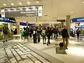 Concourse A at the airport.
.jpg.webp) Several planes parked at the airport.
Several planes parked at the airport.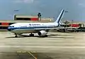 An Eastern Air Lines airplane at Atlanta in 1987. Eastern used to be one of the largest airlines at the airport before it stopped flying in 1991.
.jpg.webp) A Southwest Airlines Boeing 737-700 taking off from Atlanta.
A Southwest Airlines Boeing 737-700 taking off from Atlanta.
References
- "Operating Statistics". City of Atlanta. January 2017. Retrieved February 16, 2017.
- "Atlanta airport still the "busiest"". Hartsfield-Jackson. January 4, 2010. Archived from the original (PDF) on January 6, 2007.
- "Atlanta, GA: Hartsfield-Jackson Atlanta International (ATL)". Bureau of Transportation Statistics. February 2011.
- "Fact Sheet". City of Atlanta. February 2007. Archived from the original on December 30, 2008. Retrieved June 12, 2008.
- Zoning Ordinance, City of Atlanta, Georgia
- "City Maps." City of College Park. Retrieved on May 25, 2009. Archived 2011-09-29 at the Wayback Machine
- "Official Zoning Map Archived 2011-11-22 at the Wayback Machine." City of Hapeville. Retrieved on May 19, 2009.
- "Operating Statistics". Atlanta Department of Aviation. Archived from the original on February 21, 2011.
- "ATL Operating Statistics 2013-present". atl.com.