Geography of Nepal
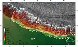
Nepal measures about 800 kilometers (497 mi) along its Himalayan axis by 150 to 250 kilometers (93 to 155 mi) across. With 147,181 square kilometers (56,827 sq mi) it slightly outranks the state of Arkansas in the United States. Nepal is landlocked by India on three sides and China's Tibet Autonomous Region to the north.
| Geography of Nepal | |
|---|---|
 | |
| Continent | Asia |
| Region | Southern Asia coordinates = 28°00′N 84°00′E |
| Area | Ranked 93rd |
| • Total | 147,181 km2 (56,827 sq mi) |
| • Land | 92.94% |
| • Water | 7.06% |
| Coastline | 0 km (0 mi) |
| Borders | Total land borders: 2,926 km (1,818 mi) China (PRC): 1,236 km (768 mi) India: 1,690 km (1,050 mi) |
| Highest point | Mount Everest 8,848 m (29,029 ft) |
| Longest river | Karnali |
| Largest lake | Rara Lake |
Related pages
This article is issued from Wikipedia. The text is licensed under Creative Commons - Attribution - Sharealike. Additional terms may apply for the media files.