Feather River
The Feather River is a river in Northern California in the United States. It is a tributary of the Sacramento River. The river originates in the Sierra Nevada mountains and is 114 kilometres (71 miles) long, flowing in a general southward direction.
| Feather River Río de las Plumas | |
|---|---|
.jpg.webp) The Feather River near its confluence with the Bear River | |
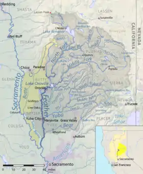 Map of the Feather River watershed. The artificially connected Sutter Basin and Butte Creek drainage basins are indicated in yellow. | |
| Location | |
| Country | United States |
| State | California |
| Region | Butte County, Yuba County, Sutter County |
| Cities | Oroville, Yuba City, Marysville |
| Physical characteristics | |
| Source | North Fork Feather River |
| - location | Confluence of Rice Creek and South Arm Rice Creek, Plumas County |
| - coordinates | 40°21′47″N 121°27′05″W[1] |
| - elevation | 5,436 ft (1,657 m)[2] |
| 2nd source | Middle Fork Feather River |
| - location | Near Beckwourth, Sierra Valley, Plumas County |
| - coordinates | 39°48′49″N 120°22′46″W[3] |
| - elevation | 4,872 ft (1,485 m)[4] |
| Source confluence | Lake Oroville |
| - location | Upstream of Oroville Dam |
| - coordinates | 39°32′14″N 121°29′00″W[5] |
| - elevation | 902 ft (275 m)[5] |
| Mouth | Sacramento River |
| - location | Verona |
| - coordinates | 38°47′08″N 121°37′17″W[6] |
| - elevation | 26 ft (7.9 m)[6] |
| Length | 73 mi (117 km), North-south[7] |
| Basin size | 6,197 sq mi (16,050 km2)[7][8] |
| Discharge | |
| - location | Nicolaus[9] |
| - average | 8,321 cu ft/s (235.6 m3/s)[9] |
| - minimum | 222 cu ft/s (6.3 m3/s) |
| - maximum | 357,000 cu ft/s (10,100 m3/s) |
| Basin features | |
| River system | Sacramento River Basin |
| Tributaries | |
| - left | Yuba River, Bear River |
| - right | Sutter Bypass |
National Wild and Scenic River | |
| Type | Wild, Scenic, Recreational |
| Designated | October 2, 1968 |
The river is an important source of drinking and irrigation water for California. The Oroville Dam is located on the river, near the city of Oroville.
Tributaries
- Bear River
- Yuba River
- Middle Fork Feather River
- North Fork Feather River
Related pages
References
- "North Fork Feather River". Geographic Names Information System. United States Geological Survey. 1981-01-19. Retrieved 2010-10-23.
- "Rice Creek". Geographic Names Information System. United States Geological Survey. 1990-08-01. Retrieved 2010-10-23.
- "Middle Fork Feather River". Geographic Names Information System. United States Geological Survey. 1981-01-19. Retrieved 2010-10-23.
- "Sierra Valley Channels". Geographic Names Information System. United States Geological Survey. 1981-01-19. Retrieved 2010-10-23.
- "Lake Oroville". Geographic Names Information System. United States Geological Survey. 1981-01-19. Retrieved 2010-10-23.
- "Feather River". Geographic Names Information System. United States Geological Survey. 1981-01-19. Retrieved 2010-10-23.
- U.S. Geological Survey. National Hydrography Dataset high-resolution flowline data. The National Map Archived 2012-03-29 at the Wayback Machine, accessed March 10, 2011
- "Boundary Descriptions and Names of Regions, Subregions, Accounting Units and Cataloging Units". U.S. Geological Survey. Retrieved 2010-08-22.
- "USGS Gage #11425000 on the Feather River near Nicolaus". National Water Information System. United States Geological Survey. 1944–1983. Retrieved 2010-09-08.
This article is issued from Wikipedia. The text is licensed under Creative Commons - Attribution - Sharealike. Additional terms may apply for the media files.