Equirectangular projection
The equirectangular projection (also called the geographic projection) is a simple map view made about 100 AD.[1] The projection maps Longitude and Latitude (vertical and horizontal map lines) to even straight lines. Because the map is stretched out, it can not be used in navigation. Its main use is to show large map areas.
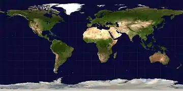
An equirectangular projection of the Earth; the standard parallel is the equator.
Related pages
- Cartography
- Cassini projection
- Gall–Peters projection with resolution regarding the use of rectangular world maps
- Panorama
References
- Flattening the Earth: Two Thousand Years of Map Projections, John P. Snyder, 1993, pp. 5-8, ISBN 0-226-76747-7.
Other websites
- Global MODIS based satellite map Archived 2006-10-09 at the Wayback Machine The blue marble: land surface, ocean color and sea ice.
- Table of examples and properties of all common projections, from radicalcartography.net.
- Panoramic Equirectangular Projection, PanoTools wiki.
This article is issued from Wikipedia. The text is licensed under Creative Commons - Attribution - Sharealike. Additional terms may apply for the media files.