Dom (mountain)
The Dom is a mountain in the Pennine Alps. It is between Randa and Saas-Fee in the canton of Valais in Switzerland.
| Dom | |
|---|---|
 The north side of the Dom and the Mischabel massif | |
| Highest point | |
| Elevation | 4,545 m (14,911 ft) |
| Prominence | 1055 m ↓ Neues Weisstor[1] |
| Parent peak | Monte Rosa |
| Isolation | 16.8 km → Nordend[2] |
| Listing |
|
| Coordinates | 46°05′42″N 7°51′36″E |
| Geography | |
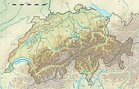 Dom Location in Switzerland | |
| Location | Valais, Switzerland |
| Parent range | Pennine Alps |
| Topo map | Swisstopo 1328 Randa |
| Climbing | |
| First ascent | 1858 by John Llewelyn Davies guided by Johann Zumtaugwald, Johann Krönig and Hieronymous Brantschen |
| Easiest route | North flank (PD) |
It is the main summit of the Mischabel group and is the second highest mountain in Switzerland, after Monte Rosa.
References
- Retrieved from the Swisstopo topographic maps. The key col is the Neues Weisstor, between the Schwarzberghorn and the Cima di Jazzi, at 3,490 metres.
- Retrieved from Google Earth. The nearest point of higher elevation is north of the Nordend.
This article is issued from Wikipedia. The text is licensed under Creative Commons - Attribution - Sharealike. Additional terms may apply for the media files.