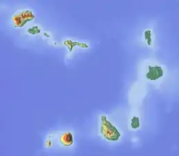
Brava, Cape Verde
Brava is an island in Cape Verde. It is in the Sotavento group. It is the smallest inhabited island of the Cape Verde archipelago.
 | |
 | |
 Brava | |
| Geography | |
|---|---|
| Location | Atlantic Ocean |
| Coordinates | 14°52′N 24°42′W |
| Area | 62.51 km2 (24.14 sq mi) |
| Length | 10.5 km (6.52 mi) |
| Width | 9.3 km (5.78 mi) |
| Highest elevation | 976 m (3202 ft) |
| Highest point | Monte Fontainhas |
| Administration | |
| Municipality | Brava |
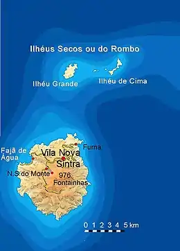
| Largest settlement | Nova Sintra |
| Demographics | |
| Population | 5,698 (2015) |
| Pop. density | 91.2/km2 (236.2/sq mi) |
For more than a century, its main industry was whaling. Now it is primarily agricultural.
History
Brava was discovered in 1462 by the Portuguese explorer Diogo Afonso.[1] Around 1620 the population of Brava started with the arrival of settlers from Madeira and the Azores.[2]
Geography
Monte Fontainhas is the highest point on the island, reaching 976 metres elevation.[3]
Municipality
Administratively, the island of Brava is covered by one municipality. There are 2 civil parishes: São João Baptista and Nossa Senhora do Monte. The municipal seat is the city Nova Sintra.
References
- Valor simbólico do centro histórico da Praia, Lourenço Conceição Gomes, Universidade Portucalense, 2008, p. 97
- Centre historique de Nova Sintra, UNESCO (in French)
- Cabo Verde, Statistical Yearbook 2015, Instituto Nacional de Estatística
This article is issued from Wikipedia. The text is licensed under Creative Commons - Attribution - Sharealike. Additional terms may apply for the media files.