Brčko District
Brčko District, officially the Brčko District of Bosnia and Herzegovina, is the self-governing administrative unit in north-eastern Bosnia and Herzegovina.[1]
Brčko District of Bosnia and Herzegovina
Брчко Дистрикт Босне и Херцеговине Brčko Distrikt Bosne i Hercegovine | |
|---|---|
Self-governing administrative unit | |
|
Flag Coat of arms | |
 Location of Brčko District within Bosnia and Herzegovina | |
| Coordinates: 44°52′0″N 18°47′0″E | |
| Country | Bosnia and Herzegovina |
| Established by final arbitration decision | 5 March 1999 |
| Statute took effect | 8 March 2000 |
| Seat | Brčko |
| Government | |
| • Mayor | Zijad Nišić (SBiH) |
| • President of the Assembly | Siniša Milić (SNSD) |
| • International Supervisor(suspended since 23 May 2012) | Michael Scanlan |
| Area | |
| • Total | 493 km2 (190 sq mi) |
| Population (2013) | |
| • Total | 83,516 |
| • Density | 170/km2 (440/sq mi) |
| Time zone | UTC+1 (CET) |
| • Summer (DST) | UTC+2 (CEST) |
| Postal code | 76100 |
| Area code | (+387) 49 |
| ISO 3166 code | BA-BRC |
| Website | Government website, Assembly website |
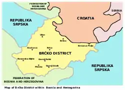
Map of the District

Dayton boundary lines before the formation of the Brčko District
References
- "GRAFIČKI PRIKAZ SALE SKUPŠTINE BRČKO DISTRIKTA BIH" (PDF). Archived from the original (PDF) on 2007-09-26. Retrieved 2007-04-26.
This article is issued from Wikipedia. The text is licensed under Creative Commons - Attribution - Sharealike. Additional terms may apply for the media files.