Bernau bei Berlin
Bernau bei Berlin (English Bernau near Berlin) is a German city in the Barnim district. The city is located about 10 km (6.2 mi) northeast of Berlin.
Bernau bei Berlin | |
|---|---|
 Coat of arms | |
Location of Bernau bei Berlin within Barnim district  | |
 Bernau bei Berlin 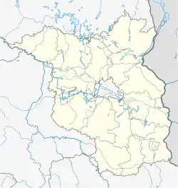 Bernau bei Berlin | |
| Coordinates: 52°40′00″N 13°34′59″E | |
| Country | Germany |
| State | Brandenburg |
| District | Barnim |
| Subdivisions | Hauptort und 4 Ortsteile |
| Government | |
| • Mayor | André Stahl (Die Linke) |
| Area | |
| • Total | 103.73 km2 (40.05 sq mi) |
| Elevation | 68 m (223 ft) |
| Population (2022-12-31)[1] | |
| • Total | 43,685 |
| • Density | 420/km2 (1,100/sq mi) |
| Time zone | UTC+01:00 (CET) |
| • Summer (DST) | UTC+02:00 (CEST) |
| Postal codes | 16321 |
| Dialling codes | 03338 |
| Vehicle registration | BAR, BER, EW |
| Website | www.bernau-bei-berlin.de |
In 1842 a railway line was opened. One of the first electrical suburban railway lines in the world has been opened in 1924. This line of the Berlin S-Bahn connected Bernau with station Stettiner Bahnhof (today Berlin Nordbahnhof) in Berlin. The Allgemeiner Deutscher Gewerkschaftsbund (ADGB) (General German Confederation of Trade Unions) opened its school in 1930. The Waldsiedlung (engl. residential area in the wood) is a district of the city where the political leaders of the GDR lived isolated from the people.
Twinned cities
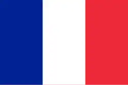 France - Champigny-sur-Marne
 Germany,
  North Rhine-Westphalia - Meckhenheim
 Poland - Skwierzyna
References
- "Bevölkerungsentwicklung und Bevölkerungsstandim Land Brandenburg Dezember 2022" (PDF). Amt für Statistik Berlin-Brandenburg (in German). June 2023.
Other websites
![]() Media related to Bernau bei Berlin at Wikimedia Commons
Media related to Bernau bei Berlin at Wikimedia Commons
- Official website of the city (German)
This article is issued from Wikipedia. The text is licensed under Creative Commons - Attribution - Sharealike. Additional terms may apply for the media files.