Atauro
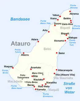
Atauro in an island of East Timor. It is about 25 km long and 9 km wide, about 140.1 km2 in area. It had 9,274 people living there at the 2015 Census. The nearest island is the Indonesian island of Liran, 12 km to the northeast.
 Atauro Island | |
 Atauro Island | |
| Geography | |
|---|---|
| Location | Southeast Asia |
| Administration | |
At 999 m above sea level, Mount Manucoco is the island's highest point.
The island is administratively divided into five sucos, each surrounding a village:
- Biqueli
- Beloi
- Macadade (formerly Anartutu)
- Maquili
- Vila Maumeta
This article is issued from Wikipedia. The text is licensed under Creative Commons - Attribution - Sharealike. Additional terms may apply for the media files.