Alb-Donau-Kreis
Alb-Donau (Alemannic German: Alb-Donau-Krois) is a rural district or county (Landkreis) in Baden-Württemberg, Germany.
Alb-Donau | |
|---|---|
 Coat of arms | |
 | |
| Country | Germany |
| State | Baden-Württemberg |
| Adm. region | Tübingen |
| Capital | Ulm |
| Area | |
| • Total | 1,357.32 km2 (524.06 sq mi) |
| Population (31 December 2022)[1] | |
| • Total | 202,476 |
| • Density | 150/km2 (390/sq mi) |
| Time zone | UTC+01:00 (CET) |
| • Summer (DST) | UTC+02:00 (CEST) |
| Vehicle registration | UL |
| Website | alb-donau-kreis.de |
History
The history of the region is linked with the history of Ulm and the Swabian Alb.
The district of Alb-Donau was established in 1973 by joining the former districts of Ulm and Ehingen.
Geography
The city of Ulm is surrounded by the district. The government of the county is in Ulm, even though Ulm is not a part of the districztIt is the administrative seat of the Alb-Donau district, although it is not part of the district.
The district is named after the Danube River (German Donau) and the Swabian Alb (Schwäbische Alb) mountains. The Danube enters the district in the southwest, runs through the southern parts of the district and leaves eastwards to Ulm. North of the Danube banks the hills of the Swabian Alb rise. The hill chain extends from southwest to northeast parallel to the course of the Danube River and is continued on either side of the district. An affluent of the Danube, the Iller River, forms the southeastern border of the Alb-Donau district, before it meets the Danube in Ulm.
Coat of arms
 |
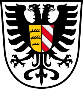
The coat of arms is identical with the arms of the former district of Ulm. The eagle was the heraldic animal of the Free Imperial City of Ulm. The shield displays the deer antlers of Württemberg and the red and white stripes of the Austrian county of Burgau (which the southern parts of the district once belonged to). |
Towns and municipalities
| Towns | Municipalities | ||
|---|---|---|---|
|
|
|
|
Other websites
- Official website Archived 2007-08-25 at the Wayback Machine (German)
- "Bevölkerung nach Nationalität und Geschlecht am 31. Dezember 2022" [Population by nationality and sex as of December 31, 2022] (CSV) (in German). Statistisches Landesamt Baden-Württemberg. June 2023.