Agout
The Agout or Agoût (Occitan: Agot) is a river in southwestern France, left tributary of the Tarn river. It flows through the Occitanie region.
| Agout | |
|---|---|
 | |
| Location | |
| Country | France |
| Physical characteristics | |
| Source | |
| - location | Massif Central |
| Mouth | |
| - location | Tarn River |
| - coordinates | 43°47′4″N 1°41′1″E |
| Length | 195 km (121 mi) |
| Basin size | 3,500 km2 (1,400 sq mi) |
| Discharge | |
| - average | 55 m3/s (1,900 cu ft/s) |
| Basin features | |
| Progression | Tarn→ Garonne→ Atlantic Ocean |
Three communes have the name of the river in their names: La Salvetat-sur-Agout, Fraisse-sur-Agout and Vielmur-sur-Agout.
Geography
The Agout river has a length of 194.4 km (120.8 mi) and a drainage basin with an area of 3,497 km2 (1,350 sq mi).[1]
Its average yearly discharge (volume of water which passes through a section of the river per unit of time) is 41 m3/s (1,400 cu ft/s) at Lavaur in the Tarn department.[2]
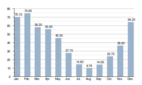
Average monthly discharge (m3/s) at Lavaur (56 years)[2]
Course
The source of the Agout is on the Monts d'Espinouse, in the southern Massif Central in the Parc Naturel Régional du Haut-Languedoc ("Regional Natural Park of High Languedoc"), in the commune of Cambon-et-Salvergues, Hérault department, at an altitude of about 1,060 m (3,478 ft).[3]
The Agout flows, in general, to the northwest and passes through the following regions, departments and communes:
- Occitanie region
- Hérault: La Salvetat-sur-Agout, Fraisse-sur-Agout
- Tarn: Brassac, Castelnau-de-Brassac, Coufouleux, Giroussens, Burlats, Lavaur, Castres, Rabastens, Saint-Sulpice
The Agout river flows through a total of 36 communes.[1]
Finally, it flows, as a left tributary into the Tarn river at Saint-Sulpice, in the Tarn department, at 98 m (322 ft) of altitude.[4]
Main tributaries
The main tributaries, with a length greater than 30 km, of the Agout are:
Gallery
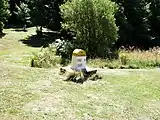 Cambon-et-Salvergues: Source of the river Agout
%252C_Maisons_sur_l'Ago%C3%BBt.JPG.webp) Houses in Castres by the Agout river
Houses in Castres by the Agout river The Agout at Giroussens
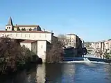 The Agout at Castres
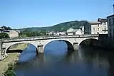 Bridge over the Agout at Brassac
_-_La_chauss%C3%A9e_du_moulin_sur_l'Agout.jpg.webp)
Related pages
References
- "L'Agout (O4--0250)" (in French). SANDRE - Portail national d'accès aux référentiels sur l'eau. Archived from the original on 3 March 2016. Retrieved 29 September 2014.
- "L'Agout à Lavaur [Pont de Lavaur]" (in French). Banque Hydro. Archived from the original on 3 March 2016. Retrieved 2 February 2017.
- "Source de l'Agout" (in French). Géoportail. Retrieved 29 September 2014.
- "Confluence de l'Agout" (in French). Géoportail. Retrieved 29 September 2014.
- "La Durenque (O42-0400)" (in French). SANDRE - Portail national d'accès aux référentiels sur l'eau. Retrieved 29 September 2014.
- "Le Thoré (O43-0400))" (in French). SANDRE - Portail national d'accès aux référentiels sur l'eau. Archived from the original on 3 March 2016. Retrieved 29 September 2014.
- "Le Sor (O45-0400)" (in French). SANDRE - Portail national d'accès aux référentiels sur l'eau. Archived from the original on 9 November 2017. Retrieved 29 September 2014.
- "Le Gijou (O41-0430)" (in French). SANDRE - Portail national d'accès aux référentiels sur l'eau. Archived from the original on 3 March 2016. Retrieved 29 September 2014.
- "Le Dadou (O47-0400)" (in French). SANDRE - Portail national d'accès aux référentiels sur l'eau. Archived from the original on 6 June 2012. Retrieved 29 September 2014.
Other websites
- Banque Hydro - Station O4692550 - L'Agout à Lavaur (Synthèse) Archived 2015-02-19 at the Wayback Machine (in French)
- Syndicat Mixte du Bassin de l'Agout (in French)