Aetingen
Aetingen is a former municipality in the new municipality of Buchegg and in the district Bucheggberg in the canton of Solothurn in Switzerland.[1]
Aetingen | |
|---|---|
 Coat of arms | |
Location of Aetingen | |
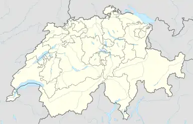 Aetingen 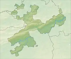 Aetingen | |
| Coordinates: 47°8′N 7°30′E | |
| Country | Switzerland |
| Canton | Solothurn |
| District | Bucheggberg |
| Area | |
| • Total | 2.85 km2 (1.10 sq mi) |
| Elevation | 480 m (1,570 ft) |
| Population (2013-12-31) | |
| • Total | 297 |
| • Density | 100/km2 (270/sq mi) |
| Time zone | UTC+01:00 (Central European Time) |
| • Summer (DST) | UTC+02:00 (Central European Summer Time) |
| Postal code(s) | 4587 |
| SFOS number | 2442 |
| Surrounded by | Bätterkinden (BE), Brügglen, Kyburg-Buchegg, Limpach (BE), Mühledorf, Unterramsern |
| Website | www SFSO statistics |
_281.JPG.webp)
Aettingen
_156.JPG.webp)
Brittern (Aetingen)
References
![]() Media related to Aetingen at Wikimedia Commons
Media related to Aetingen at Wikimedia Commons
- Nomenklaturen – Amtliches Gemeindeverzeichnis der Schweiz (in German) accessed 13 December 2014
This article is issued from Wikipedia. The text is licensed under Creative Commons - Attribution - Sharealike. Additional terms may apply for the media files.