Acklins and Crooked Islands
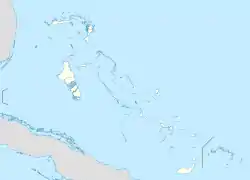
Acklins and Crooked Islands was a district of the Bahamas until 1996, and as Acklins, Crooked Island and Long Cay until 1999. The islands are at 22°30′N 74°0′W.
 | |
| Geography | |
|---|---|
| Location | Atlantic Ocean |
| Coordinates | 22°21′N 74°1′W |
| Archipelago | Bahamas |
| Area | 238−389 km2 (92−150 sq mi) |
| Administration | |
| Demographics | |
| Population | 560[1] (2010) |
The population of Acklins was 428, and Crooked Island 350, at the 2000 census.[2]
Since 1999, Acklins and Crooked Island are separate districts.
References
- "PRELIMINARY POPULATION AND HOUSING COUNT BY ISLAND AND SUPERVISORY DISTRICT, ALL BAHAMAS: CENSUS 2010" (PDF). Bahamas Department of Statistics. Archived from the original (PDF) on 2019-11-07. Retrieved 2012-05-16.
- "Bahamas, the - General Information". Geohive. Retrieved 19 February 2016.
This article is issued from Wikipedia. The text is licensed under Creative Commons - Attribution - Sharealike. Additional terms may apply for the media files.