Abriès
Abriès is a former commune in the Hautes-Alpes department and Provence-Alpes-Côte d'Azur region in southeastern France. It is now part of Abriès-Ristolas.
Abriès | |
|---|---|
Part of Abriès-Ristolas | |
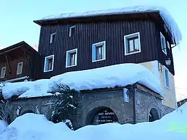 Town hall | |
 Coat of arms | |
Location of Abriès | |
 Abriès 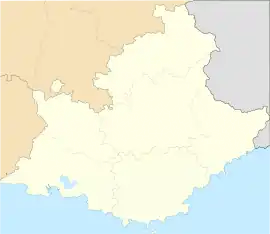 Abriès | |
| Coordinates: 44°47′46″N 6°55′40″E | |
| Country | France |
| Region | Provence-Alpes-Côte d'Azur |
| Department | Hautes-Alpes |
| Arrondissement | Briançon |
| Canton | Guillestre |
| Commune | Abriès-Ristolas |
| Area 1 | 77 km2 (30 sq mi) |
| Population (2017)[1] | 299 |
| • Density | 3.9/km2 (10/sq mi) |
| Time zone | UTC+01:00 (CET) |
| • Summer (DST) | UTC+02:00 (CEST) |
| Postal code | 05460 |
| Elevation | 1,513–3,305 m (4,964–10,843 ft) (avg. 1,547 m or 5,075 ft) |
| 1 French Land Register data, which excludes lakes, ponds, glaciers > 1 km2 (0.386 sq mi or 247 acres) and river estuaries. | |
Geography
Abriès' surroundings are very hilly. Abriès is in the Queyras National Park. The commune borders Italy.
The Guil river goes through Abriès.
Transport
Road
The D947 road passes through Abriès.
Population
| Year | Pop. | ±% |
|---|---|---|
| 2004 | 378 | — |
| 2006 | 382 | +1.1% |
| 2007 | 377 | −1.3% |
| 2008 | 372 | −1.3% |
| 2009 | 367 | −1.3% |
| 2010 | 365 | −0.5% |
| 2011 | 343 | −6.0% |
| 2012 | 333 | −2.9% |
| 2013 | 322 | −3.3% |
| 2014 | 311 | −3.4% |
| 2015 | 306 | −1.6% |
| 2016 | 302 | −1.3% |
This article is issued from Wikipedia. The text is licensed under Creative Commons - Attribution - Sharealike. Additional terms may apply for the media files.