A55 road
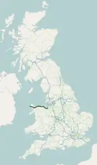
The A55, also called the North Wales Expressway (Welsh: Gwibffordd Gogledd Cymru),[1] is an important road in Great Britain. It goes between Chester, England and Holyhead, Wales. It goes along the north coast of Wales for most of its route. For most of the route, it is a dual carriageway. Many parts of the road act like a motorway.
 | ||||
|---|---|---|---|---|
| North Wales Expressway | ||||
 | ||||
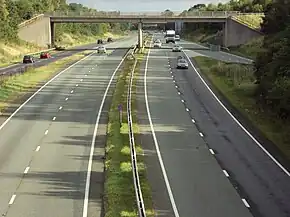
 Looking eastbound at junction 40 | ||||
| Route information | ||||
| Part of | ||||
| Maintained by Highways England North and Mid Wales Trunk Road Agent | ||||
| Length | 87 mi (140 km) | |||
| Existed | 1922–present | |||
| History | Completed: 2001 | |||
| Major junctions | ||||
| West end | Holyhead | |||
J9 → A487 road J11 → A5 road J19 → A470 road J33B → A494 road J34 → A494 road J38 → A483 road J39 → A41 road/A5115 road J40 → A51 road M53 motorway | ||||
| East end | Chester | |||
| Location | ||||
| Country | United Kingdom | |||
| Counties | Isle of Anglesey, Gwynedd, Conwy, Denbighshire, Flintshire, Cheshire | |||
| Primary destinations | Holyhead Bangor Conwy Chester | |||
| Road network | ||||
| ||||
| ||||
It is also part of the European route E22, which links to Amsterdam, Riga, and Moscow. The route once went between Bangor and Chester, but was extended to Holyhead in 2001. This links to the Republic of Ireland through the Port of Holyhead. In total, the road is 87 miles (140 km) long.[2]
Junctions
| A55 road junctions | |||||
| km | Westbound exits (B Carriageway) | Junction | Eastbound exits (A Carriageway) | ||
| 0.0 | Holyhead Fish quay, Park and ride, |
[coord 1] |
Start of road | ||
| Local traffic | TOTSO |
Local traffic only | |||
| 0.5 | Town centre A5154 | TOTSO |
Town centre A5154 | ||
| 0.7 | Trearddur Bay B4545, Kingsland | J1 |
Trearddur Bay B4545, Kingsland | ||
| 1.2 2.0 |
Trearddur Bay A5153 (B4545), Parc Cybi, Penrhos Stanley |
J2 | Trearddur Bay A5153 (B4545), Parc Cybi | ||
| 7.1 7.7 |
Valley A5 | J3 | Valley, Caergeiliog A5 | ||
| 9.6 10.2 |
Caergeiliog A5, Boderdern | J4 | Bryngwran A5, Boderdern | ||
| 14.0 14.6 |
Rhosneigr, Aberffraw A4080, Bryngwran (A5) | J5 | Rhosneigr, Aberffraw A4080, Gwalchmai (A5) | ||
| 23.2 24.0 |
Rhostrehwfa A5, Llangefni (A5114) | J6 | Pentre Berw A5, Llangefni (A5114) | ||
| 27.8 28.6 |
Gaerwen, Pentre Berw A5152 (A5) | J7 | Gaerwen, Llanfair Pwllgwyngyll A5152 (A5) | ||
| 31.3 | Llanfair Pwllgwyngyll A5, Star | J7A | No access | ||
| 32.9 33.4 |
Benllech, Amlwch A5025 | J8 | Menai Bridge, Amlwch A5025 | ||
| 33.8 | Llanfair Pwllgwyngyll A5(W), Menai Bridge A5(E), Beaumaris (A545) | J8A | No access (on-slip only) | ||
| Entering Isle of Anglesey | |||||
| 34.1 34.4 |
Britannia Bridge | ||||
| Entering Gwynedd | |||||
| 35.3 35.6 |
Bangor, Caenarfon A487 | J9 | Bangor, Caenarfon A487 | ||
| 36.4 37.0 |
Bangor A4087, Caenarfon (A487) | J10 | Bangor A4087 | ||
| 40.3 40.9 |
Bangor, Betws-y-Coed A5 | J11 Services |
Betws-y-Coed A5 | ||
| 43.6 44.2 |
Tal-y-bont | J12 | Tal-y-bont | ||
| 47.2 47.5 |
Abergwyngregyn | J13 | Abergwyngregyn | ||
| 48.9 49.2 |
Llanfairfechan | J14 | Llanfairfechan | ||
| Entering Gwynedd | Entering Conwy | ||||
| 51.7 | Llanfairfechan | J15 |
Llanfairfechan | ||
| 52.8 53.7 |
Pen-y-Clip Tunnels[3] | ||||
| 53.8 54.2 |
No access (on-slip only) | J15A | Penmaenmawr | ||
| 56.2 | Penmaenmawr | J16 |
Penmaenmawr, Dwygyfylchi | ||
| Services | No access | ||||
| 57.8 57.8 |
Dwygyfylchi | J16A | No access | ||
| 58.4 59.1 |
Penmaenbach Tunnels[3] | ||||
| 60.4 61.0 |
Conwy A547 End of special road |
J17 | Conwy A547 Start of special road[4] | ||
| 61.8 62.9 |
Conwy Tunnel[3] (53.2875°N 3.8240°W) | ||||
| 63.6 64.2 |
Conwy (A547), Deganwy A546 | J18 | Deganwy A546, Llandudno Junction (A547) | ||
| 64.8 65.5 |
Betws-y-Coed, Llandudno A470 | J19 | Llandudno, Betws-y-Coed A470 | ||
| 68.7 69.8 |
Rhos-on-Sea (B5115) | J20 | Rhos-on-Sea B5115 | ||
| 70.6 71.0 |
Colwyn Bay B5104 | J21 | Colwyn Bay B5104 | ||
| 71.5 72.0 |
Old Colwyn (A547) | J22 | Old Colwyn (A547) | ||
| 76.0 76.1 |
Llanddulas A547 Start of special road[5] |
J23 Services |
Llanddulas A547 End of special road | ||
| 80.0 80.4 |
No access (on-slip only) | J23A | Pensarn, Rhyl A548 | ||
| 81.2 81.9 |
Abergele, Rhuddlan A547 | J24 | Rhuddlan, Prestatyn A547 | ||
| 84.6 | Towyn, St. George | J24A | No access | ||
| Entering Conwy | Entering Denbighshire | ||||
| Services | |||||
| 86.7 86.8 |
Bodelwyddan, Glan Clwyd |
J25 | Bodelwyddan, Glan Clwyd | ||
| 88.2 88.8 |
St Asaph Business Park | J26 | St Asaph Business Park | ||
| 89.9 90.6 |
St Asaph, Rhyl A525 | J27 | St Asaph, Rhyl A525 | ||
| 91.6 91.6 |
Denbigh A525 | J27A | No access | ||
| 92.9 93.2 |
Rhuallt (B5429), Trefnant | J28 | Rhuallt, Tremeirchion B5429 | ||
| 96.7 97.3 |
Rhuallt, Tremeirchion (B5429) | J29 | |||
| Entering Denbighshire | Entering Flintshire | ||||
| 99.0 99.3 |
Tremeirchion | J30 | |||
| 100.3 100.8 |
Prestatyn A5151, Caerwys B5122 | J31 | Holywell A5026, Caerwys A5151 (B5122) | ||
| 108.7 108.8 |
Holywell A5026 | J32 | Rhosesmor (B5123) | ||
| 109.3 109.9 |
Rhosesmor B5123 | J32A | No access (on-slip only) | ||
| 111.3 111.4 |
Pentre Halkyn, Rhosesmor | J32B | No access | ||
| 114.6 115.3 |
Flint A5119 | J33 | Mold, Flint A5119 | ||
| 116.5 | Connah's Quay B5126 | J33A | Northop Hall | ||
| Services | |||||
| 120.0 | Mold A494 | J33B | No access (on-slip only) | ||
| 120.5 128.8 |
Queensferry A494 | J34 TOTSO[See notes] |
Queensferry A494, Manchester (M56) | ||
| 123.1 123.6 |
Buckley A550 (A549), Corwen (A5104) | J35 | Wrexham A550 | ||
| 125.3 125.9 |
Pen-y-ffordd A5104 | J36 | Broughton, Pen-y-ffordd A5104 | ||
| 128.5 | Broughton (A5104) | J36A | No access (on-slip only) | ||
| 128.6 | Entering |
Border | Entering | ||
| Wrexham, Chester A483 | J38 | Chester, Wrexham A483 | |||
| River Dee | |||||
| No access (on-slip only) | J39 | Chester A5115, Whitchurch A41 | |||
| Chester, Nantwich A51, Whitchurch (A41) | J40 | Chester, Nantwich A51 | |||
| Start of road | M53 J12 [coord 2] |
Chester, Helsby A56 Non-motorway traffic | |||
| Chester A56 | Road continues as M53 towards Ellesmere Port | ||||
Notes
| |||||
Coordinate list
| |||||
| 1.000 mi = 1.609 km; 1.000 km = 0.621 mi | |||||
References
- "The Chester to Bangor Trunk Road (A55), Talerdy Junction Phase 2, St Asaph - Environmental Impact Assessment". Welsh Government. Archived from the original on 6 June 2014. Retrieved 2014-06-05.
- "A55". IHT. Archived from the original on 31 December 2008. Retrieved 4 August 2020.
{{cite web}}: CS1 maint: bot: original URL status unknown (link) - "Tunnels". North Wales Trunk Road Agency. 2011. Archived from the original on 18 March 2012. Retrieved 2011-09-04.
- "The Special Road (Glan Conwy to Conwy Morfa) Regulations 1990". www.legislation.gov.uk. The National Archives. Retrieved 1 September 2017.
- "The Special Road (Colwyn Bay to Glan Conwy) Regulations 1985". www.legislation.gov.uk. The National Archives. Retrieved 2 September 2017.
- "Resources". Traffig Cymru/Traffic Wales. Archived from the original on 3 September 2011. Retrieved 2011-08-22.
Select Telephone & marker post locations.
This article is issued from Wikipedia. The text is licensed under Creative Commons - Attribution - Sharealike. Additional terms may apply for the media files.