North Circular Road
The North Circular Road (officially the A406 and sometimes known as simply the North Circular) is a 25.7-mile-long (41.4 km) ring road around Central London in England. It runs from Chiswick in the west to Woolwich in the east via suburban North London. It connects lots of suburbs and other trunk roads in the region. Together with the South Circular Road, it forms a ring road around central London. This ring road does not make a full circuit of the city. Instead, it is C-shaped. This is because the crossing over the River Thames in the east is made on the Woolwich Ferry.
 | |
|---|---|
| North Circular Road | |
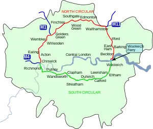 The route of the North Circular Road in Greater London, with the South Circular Road and Woolwich Ferry | |
| Route information | |
| Maintained by Transport for London | |
| Length | 25.7 mi[1] (41.4 km) |
| History | Opened: 1910 Completed: c. 1930 |
| Major junctions | |
| West end | Chiswick (M4 Junction 1) |
| East end | Beckton |
| Location | |
| Country | United Kingdom |
| Road network | |
| |
Route
The North Circular Road is the northern part of a ring-road around Central London.[2] It has seen much more investment than the South Circular Road, and it runs on much wider roads. Existing houses were demolished for the North Circular Road.[3][4] The route has other names at some points. However, it is mostly called the North Circular for route planning purposes. The route is mostly grade-separated dual carriageway from the A40 at Hanger Lane to the A13 in Beckton except for the Drury Way/Brentfield Road junction, the Golders Green Road/Brent Street junction, Henlys Corner and the section from Bounds Green to Green Lanes.[5] In worse sections, the original names such as Gunnersbury Avenue and Bowes Road are used.
Junctions
The North Circular Road has a lots of different junctions that connect to other roads. Some are complex and grade-separated, like at Charlie Brown's Roundabout near Woodford. Some are at-grade junctions with traffic lights. The original road only had at-grade junctions. Many of these were improved and grade separated in the late 1970s and early 1980s.[6]
Current junctions
| Name | Destinations | Notes |
|---|---|---|
| Chiswick flyover | ||
| Gunnersbury Park | ||
| The historic London – Oxford postal route at Ealing Common | ||
| Hanger Lane Gyratory | ||
| Near Stonebridge Park station | ||
| Brent Park, Superstores, Wembley Stadium, Industrial Estate | ||
| Staples Corner | A5 is the historic Watling Street from London to Wroxeter | |
| Brent Cross | ||
| Henlys Corner | West end of merge with the A1 | |
| Henlys Corner | A special pedestrian crossing for Jews to use on the Sabbath is located here[7] | |
| Henlys Corner | East end of merge with A1 | |
| The historic Great North Road | ||
| Colney Hatch Junction | B550 – Muswell Hill, Friern Barnet, Retail Park | |
| Hobart Corner | ||
| Bounds Green interchange | A regular congestion hotspot where traffic must narrow to single carriageway and perform a 90 degree turn.[8] Transport for London have earmarked the junction for improvement.[9] | |
| Clockhouse Junction | ||
| Great Cambridge Road Roundabout | ||
| Crooked Billet Roundabout | ||
| Waterworks | ||
| Charlie Brown's | Restricted access; eastbound exit and westbound entrance. The original Charlie Brown's was the roundabout underneath this junction. It was named after a pub next to the roundabout, which was demolished in 1972.[5][10] | |
| Charlie Brown's | ||
| Redbridge Roundabout | Also the location of Redbridge tube station | |
| The historic Roman Road from London to Colchester | ||
| Beckton Roundabout |
Former junctions
| Name | Destinations | Notes |
|---|---|---|
| Waterworks Corner | To avoid Epping Forest, the original build of the North Circular met the A104 at a different location by a water works northeast of Walthamstow.[11] | |
| Gants Hill | Gants Hill Underground station is also at this location. |
Public transport
There are three bus routes where most of the route is on the North Circular Road:
- London Buses route 34: between Bounds Green and Walthamstow/South Chingford (Crooked Billet)[12]
- London Buses route 112: between Ealing (Hanger Lane) and Finchley (Henlys Corner)[13]
- London Buses route 232: in Brent Park/Neasden and between Staples Corner/Brent Cross and Palmers Green (Green Lanes)[14]
References
- "Gunnersbury Avenue to North Circular Road, Barking". Google Maps. Retrieved 13 August 2015.
- Griffin, Christopher (2008). Nomads Under the Westway: Irish Travellers, Gypsies and Other Traders in West London. University of Hertfordshire Press. p. 129. ISBN 978-1-902-80654-9.
- Weinreb 2008.
- "A406 timeline: a half century of broken promises". Enfield Independent. 8 October 2009. Retrieved 2 March 2015.
- Dunn, Joseph (7 April 2014). "Great drives: The North Circular, London". Sunday Times Driving. Retrieved 2 March 2015.
- "North Circular Road, Ealing". Hansard. 15 December 1978. Archived from the original on 3 March 2016. Retrieved 1 March 2015.
- "Work on Henlys Corner junction improvement scheme to begin in February 2011". Transport for London. 28 January 2011. Archived from the original on 17 April 2012. Retrieved 3 July 2013.
- "Six months of traffic chaos looms as works reduce Wood Green High Road to one lane". Tottenham and Wood Green Journal. 1 September 2014. Archived from the original on 28 February 2015. Retrieved 28 February 2015.
- "Walking". Transport for London. Retrieved 28 February 2015.
- "Mystery of the Charlie Brown Roundabout". Go Britannia travel guide. Archived from the original on 29 October 2013. Retrieved 2 March 2015.
- The Times Road Map of London (Map). The Times. 1926. Retrieved 2 March 2015.
- "34 bus route". Transport for London. Retrieved 15 May 2019.
- "112 bus route". Transport for London. Retrieved 15 October 2020.
- "232 bus route". Transport for London. Retrieved 15 May 2019.
Other websites
- A406 and Ringway 2 – North Circular on CBRD
- A406 traffic updates Archived 2022-01-07 at the Wayback Machine on londontraffic.org
A roads in Zone 4 of the Great Britain road numbering scheme | ||
|---|---|---|
| ||
| ||
| ||
| ||