A2 road (England)
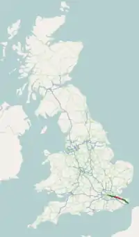
The A2 is an important road in South East England. It goes between London and Dover. In Dover, it connects to the port to France. The road follows tracks used by the Celts and the Romans over a thousand years ago. It once linked to the three main Roman ports: Rutupiae (now Richborough), Dubris (now Dover) and Portus Lemanis (in modern Lympne). It was given the name "A2" in the 1920s. Now, the road is about 72 miles (116 km) long.[1]
 | |
|---|---|
 | |
 | |
| Route information | |
| Length | 71.95 mi (115.79 km) |
| Major junctions | |
| North west end | Southwark 51.5012°N 0.0931°W |
| A3 A100 A202 A20 A102 A282 A28 A20 | |
| South east end | Dover 51.1263°N 1.3271°E |
| Location | |
| Country | United Kingdom |
| Primary destinations | Dartford, Rochester, Faversham, Canterbury |
| Road network | |
| |
References
- The Illustrated Road Book of England and Wales (1961). The Automobile Association: 32
A roads in Zone 2 of the Great Britain road numbering scheme | ||
|---|---|---|
| ||
| ||
| ||
| ||
This article is issued from Wikipedia. The text is licensed under Creative Commons - Attribution - Sharealike. Additional terms may apply for the media files.