Tropolje (Završje)
Тропоље (Завршје) | |
|---|---|
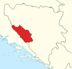 Approximate area of Tropolje | |
| Country | Bosnia and Herzegovina |
| Largest city | Livno |
| Area b | |
| • Total | 4,343 km2 (1,677 sq mi) |
| Population (2013)b | |
| • Total | 83,541 |
| • Density | 19.24/km2 (49.8/sq mi) |
| Time zone | UTC+1 (CET) |
| • Summer (DST) | UTC+2 (CEST) |
| a Tropolje is not an official subdivision of the Bosnia and Herzegovina, it is a historical region.
b The figure is an approximation based on the territorial span and population of five municipalities in Canton 10 (Bosansko Grahovo, Glamoč, Kupres, Livno, and Tomislavgrad). | |
Tropolje (English: Three-fields), since 1325, Završje (English: Upper-end), also Zapadne strane (English: Western sides), is a historical region in Bosnia and Herzegovina,[1][2][3][4] covering a part of the Dinaric Alps. It encompasses territory around karst fields of Livno, Duvno and Glamoč. The wider zone of this region also comprises the fields of Kupres and Bosansko Grahovo. Historically, the region is located on the border of Bosnia, Dalmatia and Herzegovina. The region covers 5 out of 6 municipalities of Canton 10 (except Drvar).
Etymology


Name Tropolje derives from the Serbo-Croatian words tri meaning three and polje meaning field.
History
Antiquity
Tropolje has been inhabited at least since Neolithic times. In the late Bronze Age, the Neolithic population was replaced by more warlike Indo-European tribes known as the Illyrians. The region was inhabited by Illyrian tribe of Dalmatae. Their capital was Delminium which was located in today's Tomislavgrad. The Dalmatae left many remains that testify about their presence in this area. The most important remains are the gradine, remains of Illyrian settlements which were distributed along the karst fields. The settlements were strategically well placed, that is why the Romans took over 200 years to occupy this region.
Early Middle Ages
County of Hlivno (Livanjska županija) was mentioned on the charter of the Croatian Duke Muncimir from 892. It's prefect Želimir witnessed the Charter, signed the second. Constantine VII, Emperor of the Byzantine Empire, included the county (ή Χλεβίανα) as one of 11 Croatian counties and as its center stated inhabited settlement Hlivno. It covered the hinterland of the mountain Dinara (Zadinarje).
After ecclesiastical councils in Split (925 and 928), County belonged to the jurisdiction of the archbishop of Split under whose metropolitan administration remained until the beginning of the 18th century.
High Middle Ages

The extinction of the Trpimirović dynasty resulted in forming of personal union with Hungary in the 12th century. Mid of the century the Byzantine Empire strengthens once again and conquers the area of Dalmatian cities, Zadinarje's karst fields and a large part of the southern Croatian Kingdom. After death of Manuel I Komnenos, Byzantine Emperor, in 1180 Bosnian ban Kulin expanded the area of its authority to the east and north of the župa of Hlivno while the rest remained in the Croatian Kingdom. Later, in the second half of the 13th century, Duvno became one of the župas of the Kingdom of Croatia.[3]
Until the beginning of the 14th century, župa Duvno belonged to different tribal families of the Croatian Kingdom.[3] At the very beginning of the 14th century, the župa Livno was governed by the Croatian ban Pavao Šubić's sons, Mladen, Juraj, Pavao and Grgur. In 1301, they called themselves the princes of Tropolje, Livno and Cetina–Trium camporum, Hliune et de Cetina comitibus.[2]
However, in 1325 Stjepan II Kotromanić annexed it to the Bosnian Banovina.[1] In the battles between Stjepan and Nelipić's, in 1325, the whole of Tropolje, which has since been called Završje, fell to the Bosnian banate.[1][3] From 1325/26, Livno župa passed from the Croatian state territory to the medieval Bosnian state under the rule of Ban Stjepan II Kotromanić, and, together with župas of Glamoč and Duvno, made up this region, in the sources regularly called Tropolje and referred to karst fields and its settlements, including centers such as Duvno, Livno and Glamoč.[1] From that point onward Tropolje is called Završje and/or Western sides.[2][3]
Ban Stjepan II Kotromanić reorganized župas, and bestowed local noble families titles and rule of the region. Around 1330, a duke Bogdan with his brothers was mentioned as witnesses to some contract–"from Dumno, voivode Bogdani with his brothers". Just two years later in the document dated from 15 August 1332, Ivan Pribilović is mentioned as the župan of Završje.[3]
Later, Čubranović and their branches Mihovilović and Galešić, with the sons of a certain Galeša or Galešići, are being mentioned as lords. It is recorded that in October 1332, Grand Duke Vladislav Galešić accompanied Ban in Ragusa.[2]Louis I of Hungary tried to recover the former Croatian župas and towns. In 1356, he succeeded in forcing Grgur Galešić to cede the old town and fort of Bistrica, above modern Livno, to him, but he also awarded Grgur with some lands in Slavonija, in Čava, in return. This is the first time the city of Bistrica is mentioned.[2] After the death of Luis I, the Bosnian king Tvrtko I, shortly before 1387, reunited the town and župa of Livno with his realm, which remained under the rule of the Bosnian kings until 1463 and the Bosnian fall to Ottomans.[1][2] During the 15th century, The Bosnian kings Tvrtko II and Tomaš issued charters in Livno, in 1430 and 1436, and in 1444 and 1499, respectively.[2]
Municipalities
Area of Završje covers territory of five municipalities in the Federation of Bosnia and Herzegovina: Grahovo, Glamoč, Kupres, Livno and Tomislavgrad.
| Municipality | Coat of arms | Population[5] | Area (km2)[6] |
|---|---|---|---|
| Bosansko Grahovo | 3,091 | 780.0 | |
| Glamoč | 4,038 | 1033.6 | |
| Kupres | 5,893 | 569.8 | |
| Livno | 37,487 | 994.0 | |
| Tomislavgrad | 33,032 | 967.4 |
Geography
The total area of the Tropolje (Završje) is approximately 4,343 square kilometres (1,680 sq mi). The region is located between Dalmatia to the west, Bosanska Krajina to the north, Central Bosnia to the east and Herzegovina to the south and southeast. Završje has population of 83,541—making the region the most sparsely populated region of Bosnia and Herzegovina at 19.24/km2. Most of the region consists of mountainous terrain separated by karst fields.
Large fields of Livno, Duvno, Glamoč and Kupres are located in the hinterland of the mountain Dinara from the perspective of the eastern Adriatic coast of which they are wider inland. There are also several small or very small karst fields: Grahovsko, Dobransko, Šuičko, Roško, Vukovsko and Planarsko.
Fields
Livno Field (Serbo-Croatian: Livanjsko polje) is the largest field of Tropolje. It is a long 65 km, consisting of three parts: the Upper field in the central part, Lower fields in the northeast and Buško mud (Buško blato) in the southeast. On the northwestern edge of the Livno Field, between the slopes Dinara and Šator, a narrow valley connects it with Grahovo field.
Eastern of the Livno Field is Duvno Field (Duvanjsko polje) separated from it by Kovač, Tušnica, Grabovica i Midena mountains. Field is 20 km long and 9 km wide.
Glamoč Field (Glamočko polje) is separated from the Livno Field by Šator Mountain, Staretina, Golija, Cincar and the Krug plateau. It is long 56 km and is divided on the Lower field to the northwest, up to 15 km wide, and Upper field in the southeast wide from 1 to 4 km.
Eastern of Glamoč Field is Kupres field (Kupreško polje), separated by Mountain Cincar, Slovinjand Hrblijne. It is long 26 km and is divided into two parts: Northern or Dry field (Suho polje), about 13 km wide, and Southern or Rilić field (Rilićko polje), about 8 km wide.
Topography
Mountainous terrain of the region is a part of the Dinaric Alps, linked to a Late Jurassic to recent times fold and thrust belt, itself part of the Alpine orogeny, extending southeast from the southern Alps. The Dinarides form part of a chain of mountains that stretch across southern Europe and isolate Pannonian Basin from the Mediterranean Sea. The highest mountain of the Tropolje Dinarides is Mount Vran, located on the border of the municipalities of Tomislavgrad and Jablanica with the peak called Veliki Vran (Great Vran) at 2,074 metres (6,804 ft).
| Highest mountains of Tropolje | |||
|---|---|---|---|
| Mountain | Peak | Elevation | Coordinates |
| Vran | Veliki Vran | 2,074 m (6,804 ft) | 43°40′4.8″N 17°30′18″E / 43.668000°N 17.50500°E |
| Vran | Mali Vis | 2,014 m (6,608 ft) | 43°40′41.34″N 17°29′57.08″E / 43.6781500°N 17.4991889°E |
| Cincar | Cincar | 2,006 m (6,581 ft) | 43°54′08″N 17°03′46″E / 43.90222°N 17.06278°E |
| Vran | Crno Brdo | 1,966 m (6,450 ft) | 43°40′52.96″N 17°29′37.3″E / 43.6813778°N 17.493694°E |
| Vran | Mali Vran | 1,961 m (6,434 ft) | 43°39′8.8″N 17°17′27″E / 43.652444°N 17.29083°E |
| Vran | Bijela Glava | 1,949 m (6,394 ft) | 43°39′34″N 17°29′56″E / 43.65944°N 17.49889°E |
| Vitorog | Veliki Vitorog | 1,907 m (6,257 ft) | 44°7′12″N 17°2′45″E / 44.12000°N 17.04583°E |
| Golija | Veliki Vrh | 1,886 m (6,188 ft) | 43°59′12″N 16°47′21″E / 43.98667°N 16.78917°E |
| Vran | Priorac | 1,881 m (6,171 ft) | 43°39′37″N 17°28′27″E / 43.66028°N 17.47417°E |
| Šator | Veliki Šator | 1,872 m (6,142 ft) | 44°9′26″N 13°35′23″E / 44.15722°N 13.58972°E |
Hydrology

The area is characterized by numerous karst features as ponors, underground and intermittent watercourses so there are only a few major permanent surface watercourses. On the Livno Field permanent waterways are rivers Bistrica, Sturba and Žabljak. The entire field drains to the Cetina and through it belongs to the Adriatic basin.
On the Kupres Fields two major watercourses are formed belonging to different drainage basins. Stream Mrtvica with more ponors on its course gravitate towards the Pliva River which belongs to the Black Sea drainage basin. Milač stream plunges in the south of the Field and emerges as river Šuica at the spring Veliki Stržanj. Šuica, which continues to flow to the south passes through Šuica Valley, narrow canyon and passes through Duvno Field, then plunges near Kovači. As Ričina re-emerges in Prisoje and flows into the Buško Blato, an accumulation lake located on the south side of Livno Field.
Hydrological watershed cuts Glamoč Field into two parts and divides it between the Black Sea and the Adriatic Sea drainage basin. Watercourses of the Upper Field drain as groundwater flows into the Livno Field. Northerly streams (Jaruga, Ribnik, Medin potok) belongs to the area of the Black Sea drainage basin. In months of abundant rainfall, ponor of Jaruga stream can not receive increasing flow so part of the stream drains southward and becomes part of the Adriatic Basin.
Climate
The region has a humid continental climate (Köppen: Dfb) with significant maritime influences, such as heavy precipitation and plentiful sunlight.
| Climate data for Livno (1961–1990, extremes 1949–present) | |||||||||||||
|---|---|---|---|---|---|---|---|---|---|---|---|---|---|
| Month | Jan | Feb | Mar | Apr | May | Jun | Jul | Aug | Sep | Oct | Nov | Dec | Year |
| Record high °C (°F) | 16.1 (61.0) |
20.2 (68.4) |
23.2 (73.8) |
28.1 (82.6) |
30.9 (87.6) |
36.8 (98.2) |
37.6 (99.7) |
38.2 (100.8) |
35.0 (95.0) |
28.6 (83.5) |
25.1 (77.2) |
17.1 (62.8) |
38.2 (100.8) |
| Mean daily maximum °C (°F) | 4.4 (39.9) |
6.0 (42.8) |
9.5 (49.1) |
13.7 (56.7) |
18.9 (66.0) |
22.3 (72.1) |
25.5 (77.9) |
25.5 (77.9) |
21.9 (71.4) |
16.9 (62.4) |
10.6 (51.1) |
5.6 (42.1) |
15.1 (59.2) |
| Daily mean °C (°F) | −0.6 (30.9) |
0.9 (33.6) |
4.1 (39.4) |
8.3 (46.9) |
13.0 (55.4) |
16.1 (61.0) |
18.6 (65.5) |
17.9 (64.2) |
14.2 (57.6) |
9.5 (49.1) |
4.8 (40.6) |
0.6 (33.1) |
8.9 (48.0) |
| Mean daily minimum °C (°F) | −4.8 (23.4) |
−3.4 (25.9) |
−0.8 (30.6) |
2.8 (37.0) |
6.5 (43.7) |
9.1 (48.4) |
10.6 (51.1) |
10.2 (50.4) |
7.5 (45.5) |
3.7 (38.7) |
0.1 (32.2) |
−3.6 (25.5) |
3.2 (37.8) |
| Record low °C (°F) | −29.6 (−21.3) |
−21.0 (−5.8) |
−18.9 (−2.0) |
−9.0 (15.8) |
−3.7 (25.3) |
−2.4 (27.7) |
0.4 (32.7) |
0.6 (33.1) |
−4.3 (24.3) |
−9.7 (14.5) |
−18.2 (−0.8) |
−26.4 (−15.5) |
−29.6 (−21.3) |
| Average precipitation mm (inches) | 95.4 (3.76) |
93.1 (3.67) |
96.7 (3.81) |
95.2 (3.75) |
73.3 (2.89) |
91.5 (3.60) |
50.5 (1.99) |
75.1 (2.96) |
85.2 (3.35) |
116.0 (4.57) |
149.2 (5.87) |
125.4 (4.94) |
1,146.6 (45.14) |
| Average precipitation days (≥ 0.1 mm) | 12.4 | 12.0 | 12.8 | 13.5 | 13.4 | 13.6 | 8.6 | 9.2 | 8.6 | 10.0 | 13.0 | 12.8 | 139.8 |
| Average snowy days (≥ 1.0 cm) | 10.5 | 8.5 | 4.2 | 0.7 | 0.0 | 0.0 | 0.0 | 0.0 | 0.0 | 0.0 | 3.1 | 9.8 | 36.9 |
| Average relative humidity (%) | 74.5 | 71.5 | 67.7 | 65.5 | 65.8 | 66.7 | 60.7 | 63.3 | 69.9 | 72.8 | 74.7 | 74.8 | 69.0 |
| Mean monthly sunshine hours | 110.0 | 119.7 | 153.8 | 175.1 | 217.0 | 240.3 | 306.8 | 279.1 | 222.4 | 185.4 | 121.3 | 100.7 | 2,231.7 |
| Source: Meteorological Institute of Bosnia and Herzegovina[7][8] | |||||||||||||
Demography
| Population of Tropolje in 1991 | |
|---|---|
| Nationality | Population |
| Croats | 59,523 |
| Serbs | 27,192 |
| Bosniaks | 12,012 |

According to the 2013 census, the total population of the Tropolje was around 83,541 what constitutes 2.2 percent of the total population of Bosnia and Herzegovina. Its overall population density is one of the lowest in the country at 19 people per square kilometre. Almost 85 percent of the population lives in Tropolje's south and southeast, which is area of Livno and Tomislavgrad municipalities, with about 9 thousands in the largest town of Livno.
The historical population for the Tropolje, divided into the administrative areas of Bosansko Grahovo, Glamoč, Kupres, Livno and Tomislavgrad is as follows:[9][10]
| Year | 1879 | 1885 | 1895 | 1910 | 1921 | 1931 | 1948 | 1953 | 1961a | 1971 | 1981 | 1991 | 2013 |
|---|---|---|---|---|---|---|---|---|---|---|---|---|---|
| Bosansko Grahovo (Grahovo) |
4,577 | ||||||||||||
| Glamoč | 10,196 | ||||||||||||
| Kupres (Kupreš) |
8,530 | ||||||||||||
| Livno | 20,480 | ||||||||||||
| Tomislavgrad (Županjac, Duvno) |
13,412 | ||||||||||||
| Tropolje | 57,195 |
Education
Elementary schools:
- Elementary school Bosansko Grahovo, Bosansko Grahovo
- Elementary school Fra Franjo Glavinić, Glamoč
- Elementary school Fra Lovro Karaula, Livno
- Elementary school Fra Mijo Čuić, Brišnik
- Elementary school Fra Miroslav Džaja, Kupres
- Elementary school Ivan Goran Kovačić, Livno
- Elementary school Zabrišće, Zabrišće
- Local departments: Držanlijae, Guber, Grborezi, Bila i Srđević
- Elementary school Orguz, Orguz
- Local departments: Čuklić
- Elementary school Lištani, Lištani
- Local departments: Ćaić[11]
- Elementary school Zabrišće, Zabrišće
- Elementary school Ivan Mažuranić, Tomislavgrad
- Elementary school Ivan Mažuranić, Kongora
- Elementary school Dr. Franjo Nevistić, Šujica
- Local departments: Eminovo Selo, Mokronoge, Sarajlije, Oplećani, Mandino Selo, Borčani.[12]
- Elementary school Stjepan Radić, Prisoje
High schools:
- Marko Marulić Gymnasium Tomislavgrad
- Vocational school Tomislavgrad
- Livno Gymnasium
- Silvije Strahimir Kranjčević Vocational school Livno
- Economic school Livno
- High school Glamoč
- High school Kupres
Culture
Museums and art galleries

Tropolje is home to few museums, galleries, and other institutions. The first of these is the Museum of the Franciscan Monastery Gorica in Livno, established on 2 October 1995 with the goal of collecting and preserving museum's holdings from Tropolje region and further. It has its roots in the 19th century and the work of the Franciscans from Livno, who visited archaeological sites collecting antiquities and invested effort in establishing a museum at the monastery. This is reflected in a document from 1896 in which they seek permission from the National Government in Sarajevo to display antique weapons in a public room at the monastery.[13]
Franciscan Monastery in Tomislavgrad has a Museum with archaeological, ethnographic, sacral and African exhibitions. The most significant archaeological finding is the Duvanjska ploča (stone-carved slate) found in the 1960s near the village of Prisoje, dating back to the 2nd century. The Ethnographic collection is composed of traditional attire and jewellery, sacral collection of the 17th and 19th century chalices, and the African collection of artefacts brought from Africa by Franciscan missionaries.[14]
The memorial complex 25 May 1944 in Drvar was established after the World War II near Tito's cave, and was one of the main tourist attractions in Socialist Federal Republic of Yugoslavia, visited by more than 200,000 tourists a year.[15]
References
- 1 2 3 4 5 Alen Lepirica (February 2009). "Historijsko-geografski razvoj granica Bosne i Hercegovine". Zbornik radova. Odsjek za geografiju, Prirodno-matematički fakultet, Univerzitet u Tuzli. 6 (6): 54. Retrieved 2 January 2024.
- 1 2 3 4 5 6 7 "Stari grad u Livnu (Bistrički grad)". old.kons.gov.ba. Komisija za očuvanje nacionalnih spomenika. Retrieved 2 January 2024.
- 1 2 3 4 5 6 "Nekropole sa stećcima u Lipi". old.kons.gov.ba. Komisija za očuvanje nacionalnih spomenika. Retrieved 2 January 2024.
- ↑ Elvira Baždar - Kadrić (April 2022). "REGIONALIZACIJA BOSANSKOHERCEGOVAČKOG PROSTORA SA OSVRTOM NA USPOSTAVU I FUNKCIONISANJE REGIONALNE STRUKTURE U ORGANIZACIJI PRIVREDNE KOMORE FEDERACIJE BOSNE I HERCEGOVINE" (PDF). Politologija usmjerenje: evropske integracije: 22. Retrieved 2 January 2024.
- ↑ "Rezultati popisa 2013. (Census 2013 Results)" (PDF). bhas.ba/ (in Croatian). Agency for Statistics of Bosnia and Herzegovina. Retrieved 7 November 2013.
- ↑ (in Bosnian and Croatian) "Kanton 10 u brojkama (Canton 10 in numbers)" (PDF). The Federal Office of Statistics of Federation of Bosnia and Herzegovina. Retrieved 28 May 2013.
- ↑ "Meteorlogical data for station Livno in period 1961–1990". Meteorological Institute of Bosnia and Herzegovina. Archived from the original on 30 April 2018. Retrieved 30 April 2018.
- ↑ "Livno: Record mensili dal 1949" (in Italian). Meteorological Institute of Bosnia and Herzegovina. Retrieved 10 November 2019.
- ↑ Marić, Franjo (1996). Pregled pučanstva Bosne i Hercegovine između 1879. i 1995. godine [Overview of the population of Bosnia and Herzegovina between 1879 and 1995] (in Croatian). Zagreb. ISBN 953-6055-18-X.
{{cite book}}: CS1 maint: location missing publisher (link) - ↑ "Rezultati popisa 2013. (Census 2013 Results)" (PDF). bhas.ba/ (in Croatian). Agency for Statistics of Bosnia and Herzegovina. Retrieved 7 November 2013.
- ↑ "About School". osigk-livno.com/. Elementary school Ivan Goran Kovačić. Retrieved 15 December 2015.
- ↑ "About School". os-imazuranica-tg.com/. Elementary school Ivan Mažuranić. Retrieved 15 December 2015.
- ↑ "Povijest muzeja (History of the museum)". fmgg-livno.com/ (in Croatian). Franciscan Museum and Gallery Gorica (FMGG). Retrieved 1 May 2014.
- ↑ "Samostanski muzej (Monastery Museum)". samostan-tomislavgrad.info (in Croatian). Franciscan Monastery Tomislavgrad. Retrieved 1 May 2014.
- ↑ "Tito's cave in Drvar". exploringbosnia.com/. Archived from the original on 23 January 2013. Retrieved 1 May 2014.
43°49′25″N 17°00′15″E / 43.82361°N 17.00417°E
| Geographical |
|  | ||||||
|---|---|---|---|---|---|---|---|---|
| Historical |
| |||||||