| Wethau | |
|---|---|
 | |
| Location | |
| Country | Germany |
| States | Saxony-Anhalt and Thuringia |
| Physical characteristics | |
| Source | |
| • elevation | 330.0 m (1,082.7 ft) NN |
| Mouth | |
• location | Saale |
• coordinates | 51°09′30″N 11°51′42″E / 51.1582°N 11.8618°E |
• elevation | 100.1 m (328 ft) NN |
| Length | 30 km (19 mi) |
| Basin size | 238.1 km2 (91.9 sq mi) |
| Basin features | |
| Progression | Saale→ Elbe→ North Sea |
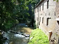
The Wethau is a river which springs from Hohendorf, Saale-Holzland-Kreis and runs through Thuringia and Saxony-Anhalt. It flows into the River Saale at Schönburg (Saale), Burgenlandkreis. The River Wethau falls 229.9 metres (754 ft) and is 30 kilometres (19 mi) long.
See also
This article is issued from Wikipedia. The text is licensed under Creative Commons - Attribution - Sharealike. Additional terms may apply for the media files.