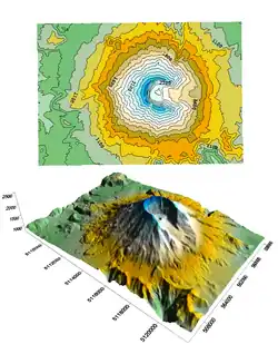
A 3D surface map of Mt. St. Helens with a 2D contour map above for comparison.
In mathematics, geology, and cartography, a surface map is a 2D perspective representation of a 3-dimensional surface.
Surface maps usually represent real-world entities such as landforms or the surfaces of objects. They can, however, serve as an abstraction where the third, or even all of the dimensions correspond to non-spatial data. In this capacity they act more as graphs than maps.
This article is issued from Wikipedia. The text is licensed under Creative Commons - Attribution - Sharealike. Additional terms may apply for the media files.