The Strohner Märchen
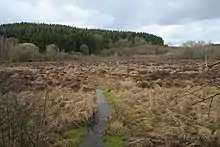
The Strohner Maarchen (also Strohner Märchen[1]) is a dry maar near the village of Strohn in the Volcanic Eifel region of Germany. Its bowl forms an elongated oval and has a diameter of about 210 x 140 metres. Its name ("maarchen" means "little maar") stems from the fact that it is small for a maar. Together with the Pulvermaar to the north and the adjacent hill of Römerberg the Strohner Maarchen lies within the nature reserve of Pulvermaar mit Römerberg und Strohner Märchen.[2]
Vulcanologists from the Smithsonian Institution estimate the last eruption of the Strohner Maar and Pulvermaar in 8,300 BC.[3]
Footnotes and references
- ↑ On maps also called Dürres Maar, but this is not the Dürres Maar near Holzmaar
- ↑ Rechtsverordnung über das Naturschutzgebiet "Pulvermaar mit Römerberg und Strohner Märchen" (pdf; 93 kB) by the administrative council of Trier dated 14 March 1984
- ↑ "West Eifel Volcanic Field". Global Volcanism Program. Smithsonian Institution.
External links
Wikimedia Commons has media related to Strohner Märchen.
This article is issued from Wikipedia. The text is licensed under Creative Commons - Attribution - Sharealike. Additional terms may apply for the media files.