Don Salvador Benedicto
Salvador Benedicto | |
|---|---|
| Municipality of Don Salvador Benedicto | |
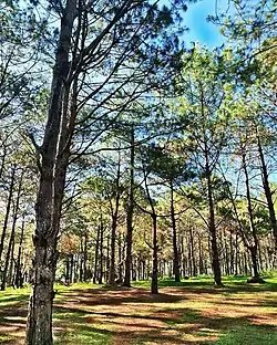 DSB Pinewood Forest | |
 Flag  Seal | |
| Nickname: Summer Capital of Negros Occidental | |
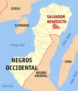 Map of Negros Occidental with Don Salvador Benedicto highlighted | |
OpenStreetMap | |
.svg.png.webp) Don Salvador Benedicto Location within the Philippines | |
| Coordinates: 10°33′02″N 123°14′11″E / 10.55056°N 123.23639°E | |
| Country | Philippines |
| Region | Western Visayas |
| Province | Negros Occidental |
| District | 1st district |
| Founded | February 9, 1983 |
| Barangays | 7 (see Barangays) |
| Government | |
| • Type | Sangguniang Bayan |
| • Mayor | Laurence Marxlen J. dela Cruz |
| • Vice Mayor | Nehemiah Joe J. dela Cruz |
| • Representative | Gerardo P. Valmayor Jr. |
| • Municipal Council | Members |
| • Electorate | 18,632 voters (2022) |
| Area | |
| • Total | 170.50 km2 (65.83 sq mi) |
| Elevation | 715 m (2,346 ft) |
| Highest elevation | 1,535 m (5,036 ft) |
| Lowest elevation | 260 m (850 ft) |
| Population (2020 census)[3] | |
| • Total | 26,922 |
| • Density | 160/km2 (410/sq mi) |
| • Households | 6,390 |
| Economy | |
| • Income class | 4th municipal income class |
| • Poverty incidence | 32.40 |
| • Revenue | ₱ 123.2 million (2020) |
| • Assets | ₱ 317.2 million (2020) |
| • Expenditure | ₱ 118.3 million (2020) |
| • Liabilities | ₱ 120 million (2020) |
| Service provider | |
| • Electricity | Central Negros Electric Cooperative (CENECO) |
| Time zone | UTC+8 (PST) |
| ZIP code | 6117 |
| PSGC | |
| IDD : area code | +63 (0)34 |
| Native languages | Hiligaynon Tagalog Cebuano |
Don Salvador Benedicto, officially the Municipality of Don Salvador Benedicto (Hiligaynon: Banwa sang Don Salvador Benedicto; Tagalog: Bayan ng Don Salvador Benedicto) or simply Salvador Benedicto and abbreviated as DSB, is a 4th class municipality in the province of Negros Occidental, Philippines. According to the 2020 census, it has a population of 26,922 people.[3]
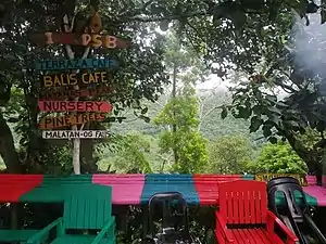
The municipality is a post-colonial provincial hill station, designated the Summer Capital of Negros Occidental, and is a popular tourist site.[5]
History

Located at the center of the mountains of northern Negros Occidental, Don Salvador Benedicto was chartered through Batas Pambansa Bilang 336 by then President Ferdinand Marcos. It consolidated all the remote barangays of San Carlos City and the towns of Calatrava and Murcia which were apparently neglected due to inaccessibility.
The town is named after the former Vice Governor Salvador Valois Benedicto (March 31, 1889–November 28, 1956) who played an important role in the setting up of a Revolutionary Government in Negros Island particularly in Barangay Igmaya-an, when the country was occupied by the Japanese during World War II. He was also the main guerrilla coordinator in both Negros Oriental and Negros Occidental during the said war. Salvador Benedicto is a relative of Roberto Benedicto, former President Marcos' crony.
 DSB Tourism Marker
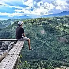 Overlooking view at DSB
Geography
Don Salvador Benedicto is 47 kilometres (29 mi) east of Bacolod, via Negros Occidental Eco-Tourism Highway (N69).
Barangays
Don Salvador Benedicto is politically subdivided into 7 barangays. Each barangay consists of puroks and some have sitios.
- Bago (Lalung)
- Bagong Silang (Marcelo)
- Bunga
- Igmaya-an
- Kumaliskis
- Pandanon
- Pinowayan (Prosperidad)
Climate
| Climate data for Don Salvador Benedicto, Negros Occidental | |||||||||||||
|---|---|---|---|---|---|---|---|---|---|---|---|---|---|
| Month | Jan | Feb | Mar | Apr | May | Jun | Jul | Aug | Sep | Oct | Nov | Dec | Year |
| Mean daily maximum °C (°F) | 23 (73) |
24 (75) |
26 (79) |
27 (81) |
27 (81) |
26 (79) |
25 (77) |
25 (77) |
25 (77) |
25 (77) |
24 (75) |
24 (75) |
25 (77) |
| Mean daily minimum °C (°F) | 19 (66) |
18 (64) |
19 (66) |
20 (68) |
21 (70) |
21 (70) |
20 (68) |
20 (68) |
20 (68) |
20 (68) |
20 (68) |
19 (66) |
20 (68) |
| Average precipitation mm (inches) | 120 (4.7) |
87 (3.4) |
95 (3.7) |
97 (3.8) |
187 (7.4) |
263 (10.4) |
251 (9.9) |
220 (8.7) |
227 (8.9) |
268 (10.6) |
220 (8.7) |
158 (6.2) |
2,193 (86.4) |
| Average rainy days | 16.1 | 12.6 | 15.4 | 16.8 | 25.8 | 28.4 | 29.1 | 27.9 | 27.7 | 28.5 | 23.9 | 18.4 | 270.6 |
| Source: Meteoblue[6] | |||||||||||||
Demographics
| Year | Pop. | ±% p.a. |
|---|---|---|
| 1990 | 13,538 | — |
| 1995 | 17,635 | +5.08% |
| 2000 | 17,259 | −0.46% |
| 2007 | 22,979 | +4.03% |
| 2010 | 23,624 | +1.01% |
| 2015 | 25,662 | +1.59% |
| 2020 | 26,922 | +0.95% |
| Source: Philippine Statistics Authority[7][8][9][10] | ||
Major languages are Hiligaynon, followed by Cebuano with English and Filipino being used as second languages.
Economy

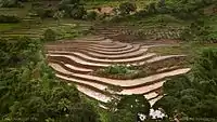
Although a small town, the town of Don Salvador Benedicto has seen a rise in its municipal economy thanks to tourism and local agriculture. Due to its high altitude like Baguio, the town can support crops that grow in temperate areas, making it ideal for a multitude of farming businesses. Tourism is on the rise for the town especially when travellers head out into the heart of the province. Also located in the municipality are the Choco Hills, similar to Bohol's Chocolate Hills, with shared boundary of Barangay Prosperidad, San Carlos City.[18]
See also

References
- ↑ Municipality of Don Salvador Benedicto | (DILG)
- ↑ "2015 Census of Population, Report No. 3 – Population, Land Area, and Population Density" (PDF). Philippine Statistics Authority. Quezon City, Philippines. August 2016. ISSN 0117-1453. Archived (PDF) from the original on May 25, 2021. Retrieved July 16, 2021.
- 1 2 Census of Population (2020). "Region VI (Western Visayas)". Total Population by Province, City, Municipality and Barangay. Philippine Statistics Authority. Retrieved 8 July 2021.
- ↑ "PSA Releases the 2018 Municipal and City Level Poverty Estimates". Philippine Statistics Authority. 15 December 2021. Retrieved 22 January 2022.
- ↑ "Things to see and do in Don Salvador Benedicto, Negros Occidental". Yap, Roxie. Retrieved August 24, 2008.
- ↑ "Don Salvador Benedicto: Average Temperatures and Rainfall". Meteoblue. Retrieved 7 May 2020.
- ↑ Census of Population (2015). "Region VI (Western Visayas)". Total Population by Province, City, Municipality and Barangay. Philippine Statistics Authority. Retrieved 20 June 2016.
- ↑ Census of Population and Housing (2010). "Region VI (Western Visayas)" (PDF). Total Population by Province, City, Municipality and Barangay. National Statistics Office. Retrieved 29 June 2016.
- ↑ Censuses of Population (1903–2007). "Region VI (Western Visayas)". Table 1. Population Enumerated in Various Censuses by Province/Highly Urbanized City: 1903 to 2007. National Statistics Office.
{{cite encyclopedia}}: CS1 maint: numeric names: authors list (link) - ↑ "Province of Aklan". Municipality Population Data. Local Water Utilities Administration Research Division. Retrieved 17 December 2016.
- ↑ "Poverty incidence (PI):". Philippine Statistics Authority. Retrieved December 28, 2020.
- ↑ "Estimation of Local Poverty in the Philippines" (PDF). Philippine Statistics Authority. 29 November 2005.
- ↑ "2003 City and Municipal Level Poverty Estimates" (PDF). Philippine Statistics Authority. 23 March 2009.
- ↑ "City and Municipal Level Poverty Estimates; 2006 and 2009" (PDF). Philippine Statistics Authority. 3 August 2012.
- ↑ "2012 Municipal and City Level Poverty Estimates" (PDF). Philippine Statistics Authority. 31 May 2016.
- ↑ "Municipal and City Level Small Area Poverty Estimates; 2009, 2012 and 2015". Philippine Statistics Authority. 10 July 2019.
- ↑ "PSA Releases the 2018 Municipal and City Level Poverty Estimates". Philippine Statistics Authority. 15 December 2021. Retrieved 22 January 2022.
- ↑ "Agriculture and Tourism Potentials of Don Salvador Benedicto". Reyes, Glady. Retrieved February 11, 2010.
External links
- Don Salvador Benedicto Profile at the Official Website of Negros Occidental
- Philippine Standard Geographic Code
- Philippine Census Information
Places adjacent to Don Salvador Benedicto | ||||||||||||||||
|---|---|---|---|---|---|---|---|---|---|---|---|---|---|---|---|---|
| ||||||||||||||||
Bacolod (capital and largest city) | |
| Municipalities | |
| Component cities | |
| Highly urbanized city |
|