Route 6 | ||||
|---|---|---|---|---|
| Route information | ||||
| Maintained by MoDOT | ||||
| Length | 211 mi (340 km) | |||
| Existed | 1922–present | |||
| Major junctions | ||||
| West end | ||||
| East end | ||||
| Location | ||||
| Country | United States | |||
| State | Missouri | |||
| Highway system | ||||
| ||||

Route 6 is a 211-mile-long (340 km) state highway in the northern part of the U.S. state of Missouri. It travels from I-29 Bus./US 169 in St. Joseph to US 24/US 61 about 6 miles (9.7 km) west of Quincy, Illinois. Route 6, if only a few miles longer in each direction, would be the only state highway to cross Missouri west to east. It is one of the original 1922 highways in Missouri.
Route description
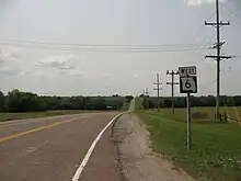
MO 6 Westbound after its concurrency with U.S. Route 69 near Altamont
Major intersections
| County | Location | mi[1] | km | Destinations | Notes |
|---|---|---|---|---|---|
| Buchanan | St. Joseph | 0.0 | 0.0 | ||
| 0.5 | 0.80 | I-29 exit 47 | |||
| DeKalb | | 13.0 | 20.9 | west end of Route 31 overlap | |
| Oak | 22.9 | 36.9 | east end of Route 31 overlap | ||
| Maysville | 32.0 | 51.5 | |||
| Daviess | | 43.7 | 70.3 | I-35 exit 64 | |
| | 45.7 | 73.5 | west end of US 69 overlap | ||
| | 46.8 | 75.3 | east end of US 69 overlap | ||
| Gallatin | 55.3 | 89.0 | west end of Route 13 overlap | ||
| | 56.9 | 91.6 | east end of Route 13 overlap | ||
| | 66.0 | 106.2 | |||
| Grundy | | 75.0 | 120.7 | ||
| Trenton | 78.9 | 127.0 | west end of US 65 Bus. overlap | ||
| 79.0 | 127.1 | interchange; east end of US 65 Bus. overlap | |||
| | 92.4 | 148.7 | west end of Route 139 overlap | ||
| Sullivan | Humphreys | 95.2 | 153.2 | east end of Route 139 overlap | |
| | 104.4 | 168.0 | west end of Route 5 overlap | ||
| | 107.6 | 173.2 | |||
| Milan | 110.3 | 177.5 | |||
| 110.5 | 177.8 | east end of Route 5 overlap | |||
| Green City | 119.7 | 192.6 | |||
| Adair | | 127.7 | 205.5 | west end of Route 149 overlap | |
| Novinger | 133.7 | 215.2 | east end of Route 149 overlap | ||
| | 137.5 | 221.3 | |||
| Kirksville | 140.8 | 226.6 | west end of US 63 Bus. overlap | ||
| 142.4 | 229.2 | east end of US 63 Bus. overlap | |||
| 143.4 | 230.8 | west end of US 63/MO 11 overlap | |||
| 145.4 | 234.0 | east end of US 63/MO 11 overlap | |||
| Knox | | 166.5 | 268.0 | west end of Route 15 overlap | |
| Edina | 167.4 | 269.4 | east end of Route 15 overlap | ||
| Lewis | | 188.5 | 303.4 | ||
| Ewing | 195.5 | 314.6 | |||
| | Outer Road - Taylor | ||||
| Marion | | 211 | 340 | interchange | |
1.000 mi = 1.609 km; 1.000 km = 0.621 mi
| |||||
See also
![]() Media related to Missouri Route 6 at Wikimedia Commons
Media related to Missouri Route 6 at Wikimedia Commons
Template:Attached KML/Missouri Route 6
KML is not from Wikidata
References
This article is issued from Wikipedia. The text is licensed under Creative Commons - Attribution - Sharealike. Additional terms may apply for the media files.