 | ||||
|---|---|---|---|---|
.svg.png.webp) | ||||
| Route information | ||||
| Maintained by WCDTPW | ||||
| Length | 150 km (93 mi) | |||
| Major junctions | ||||
| West end | ||||
| East end | ||||
| Location | ||||
| Country | South Africa | |||
| Major cities | Malmesbury, Riebeek-Kasteel, Tulbagh, Ceres, Touws River | |||
| Highway system | ||||
| ||||

The R46 between Riebeek-Kasteel and Malmesbury
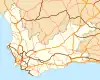
The R46 is a provincial route in Western Cape, South Africa that connects Malmesbury with Touws River, via Riebeek-Kasteel, Tulbagh and Ceres. The R46 is co-signed with the R44 between Gouda and Hermon in the Berg River valley. [1]
References
- ↑ "RDDA SOUTH AFRICAN NUMBERED ROUTE DESCRIPTION AND DESTINATION ANALYSIS". NATIONAL DEPARTMENT OF TRANSPORT. May 2012. Retrieved 25 March 2021.
External links
This article is issued from Wikipedia. The text is licensed under Creative Commons - Attribution - Sharealike. Additional terms may apply for the media files.