Route 108 | ||||
|---|---|---|---|---|
 | ||||
| Route information | ||||
| Maintained by Transports Québec | ||||
| Length | 177.9 km[1] (110.5 mi) | |||
| History | ||||
| Major junctions | ||||
| West end | ||||
| East end | ||||
| Location | ||||
| Country | Canada | |||
| Province | Quebec | |||
| Highway system | ||||
| ||||

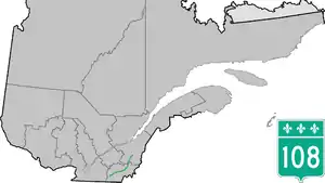
Route 108 is a two-lane east/west highway on the south shore of the Saint Lawrence River in the Eastern Townships and Chaudière-Appalaches regions of Quebec, Canada. Its eastern terminus is in Beauceville at the junction of Route 173, and the western terminus is at the junction of Route 112 in Magog.
Municipalities along Route 108
Major intersections
| RCM or ET | Municipality | km | Junction | Notes |
|---|---|---|---|---|
Western terminus of Route 108 | ||||
| Memphrémagog | Magog | 0.0 | 112 WEST: to Orford 112 EAST: to Omerville | |
| 5.7 5.9 |
55 SOUTH: to Sainte-Catherine-de-Hatley 55 NORTH: to Omerville | |||
| Sainte-Catherine-de-Hatley | 12.5 | 216 EAST: to Sherbrooke | ||
| Coaticook | Waterville | 26.7 | 143 SOUTH: to Hatley | |
| Sherbrooke | Lennoxville | 30.0 | 147 SOUTH: to Compton | |
| 32.6 | 143 NORTH: to Sherbrooke | |||
| 37.6 | 251 SOUTH: to Martinville | |||
| Le Haut-Saint-François | Eaton | 48.8 | 210 EAST: to Newport | |
| Cookshire | 53.8 | 253 SOUTH: to Saint-Isidore-de-Clifton 253 NORTH: to Westbury | ||
| 54.1 | 212 EAST: to Newport | |||
| Bury | 61.9 63.4 |
214 WEST: to East Angus 214 EAST: to Scotstown | ||
| 66.9 | 255 NORTH: to Dudswell | |||
| Lingwick | 82.9 | 257 SOUTH: to Scotstown 257 NORTH: to Weedon | ||
| Le Granit | Stornoway | 105.5 | 161 SOUTH: to Nantes 161 NORTH: to Stratford | |
| Lambton | 120.1 122.1 |
263 NORTH: to Sainte-Praxède 263 SOUTH: to Saint-Sébastien | ||
| Beauce-Sartigan | La Guadeloupe | 140.7 | 269 SOUTH: to Saint-Honoré-de-Shenley | |
| Saint-Éphrem-de-Beauce | 146.1 | 269 NORTH: to Adstock | ||
| 152.6 | 271 SOUTH: to Saint-Benoît-Labre 271 NORTH: to Sainte-Clotilde-de-Beauce | |||
| Beauceville | 177.9 | 173 SOUTH: to Notre-Dame-des-Pins 173 NORTH: to Saint-Joseph-de-Beauce | ||
Eastern terminus of Route 108 | ||||
See also
.jpg.webp)
Route 108 near North Hatley, Quebec
References
- ↑ Ministère des transports, "Distances routières", page 56, Les Publications du Québec, 2005
External links
- Official Transport Quebec Road Map (Courtesy of the Quebec Ministry of Transportation) (in French)
- Route 108 on Google Maps
This article is issued from Wikipedia. The text is licensed under Creative Commons - Attribution - Sharealike. Additional terms may apply for the media files.