| Passwang Pass | |
|---|---|
 Passwang Pass | |
| Elevation | 1,204 m (3,950 ft) |
| Traversed by | Road |
| Location | Solothurn, Switzerland |
| Range | Jura Mountains |
| Coordinates | 47°21′30″N 07°39′22″E / 47.35833°N 7.65611°E |
 Passwang Pass Location in Switzerland | |
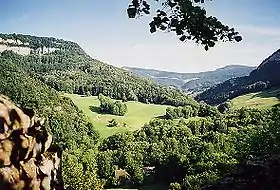
Passwang Pass (elevation 1,204 m (3,950 ft)) is a high mountain pass in the Jura Mountains in the canton of Solothurn in Switzerland.
It connects the southern part of the canton of Solothurn via Mümliswil-Ramiswil (south of the pass) and Beinwil, Solothurn (northern side) with the so-called Schwarzbubenland (officially Amtei Dorneck-Thierstein, consisting of the canton of Solothurn districts Thierstein and Dorneck) north of the Passwang mountain chain, and ultimately with the Laufen District in the canton of Basel-Landschaft.
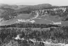
Aerial view (1965)
See also
References
Wikimedia Commons has media related to Passwang.
- Swisstopo topographic maps
This article is issued from Wikipedia. The text is licensed under Creative Commons - Attribution - Sharealike. Additional terms may apply for the media files.