Muratpaşa | |
|---|---|
District and municipality | |
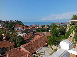
 Kaleiçi (Old Town) in Muratpaşa, Antalya | |
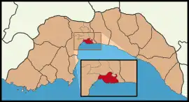
 Map showing Muratpaşa District in Antalya Province | |
 Muratpaşa Location in Turkey | |
| Coordinates: 36°52′57″N 30°46′09″E / 36.88250°N 30.76917°E | |
| Country | Turkey |
| Province | Antalya |
| Government | |
| • Mayor | Ümit Uysal (CHP) |
| • Kaymakam | Orhan Burhan |
| Area | 96 km2 (37 sq mi) |
| Elevation | 39 m (128 ft) |
| Population (2022)[1] | 526,293 |
| • Density | 5,500/km2 (14,000/sq mi) |
| Time zone | TRT (UTC+3) |
| Postal code | 07010, 07030–07050, 07100, 07160, 07200, 07230, 07300–07310 |
| Area code | (+90) 242 |
| Website | www |
Muratpaşa is a municipality and district of Antalya Province, Turkey.[2] Its area is 96 km2,[3] and its population is 526,293 (2022).[1] The district covers part of the city centre of Antalya, and has a coastline of 20 km (12 mi). The Mediterranean Sea lies to the south of the district. Ümit Uysal is the mayor of Muratpaşa.[4]
History

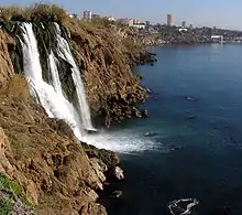
Düden Waterfall in Muratpaşa, Antalya
Modern day district of Muratpaşa is home to Kaleiçi, the historic center founded by Attalus II, King of Pergamon around 150 BC. Since then, the district has been under Lydian, Roman, Persian, Byzantine, Seljuk, Cypriot, Teke, Ottoman, and —after the Italian occupation— Turkish rule.[5]
Composition
There are 55 neighbourhoods in Muratpaşa District:[6]
- Altındağ
- Bahçelievler
- Balbey
- Barbaros
- Bayındır
- Çağlayan
- Çaybaşı
- Cumhuriyet
- Demircikara
- Deniz
- Doğuyaka
- Dutlubahçe
- Elmalı
- Ermenek
- Etiler
- Fener
- Gebizli
- Gençlik
- Güvenlik
- Güzelbağ
- Güzeloba
- Güzeloluk
- Haşimişcan
- Kılıçarslan
- Kırcami
- Kışla
- Kızılarık
- Kızılsaray
- Kızıltoprak
- Konuksever
- Mehmetçik
- Meltem
- Memurevleri
- Meydankavağı
- Muratpaşa
- Sedir
- Selçuk
- Sinan
- Şirinyalı
- Soğuksu
- Tahılpazarı
- Tarım
- Topçular
- Tuzcular
- Üçgen
- Varlık
- Yenigöl
- Yenigün
- Yeşilbahçe
- Yeşildere
- Yeşilova
- Yıldız
- Yüksekalan
- Zerdalilik
- Zümrütova
See also
- Muratpaşa Belediyesi Spor Kulübü, the local sports club
References
- 1 2 "Address-based population registration system (ADNKS) results dated 31 December 2022, Favorite Reports" (XLS). TÜİK. Retrieved 22 May 2023.
- ↑ Büyükşehir İlçe Belediyesi, Turkey Civil Administration Departments Inventory. Retrieved 8 June 2023.
- ↑ "İl ve İlçe Yüz ölçümleri". General Directorate of Mapping. Retrieved 22 May 2023.
- ↑ Gazete, Banka (23 November 2021). "Başkan Uysal: 'ASSİM, Antalya'nın turizm alanındaki düşünce kuruluşu olabilir'". Gazete Banka. p. https://gazetebanka.com/. Retrieved 23 November 2021.
- ↑ "Antalya Muratpaşa Belediyesi". muratpasa-bld.gov.tr. Retrieved 2018-05-13.
- ↑ Mahalle, Turkey Civil Administration Departments Inventory. Retrieved 22 May 2023.
External links
This article is issued from Wikipedia. The text is licensed under Creative Commons - Attribution - Sharealike. Additional terms may apply for the media files.
