Železná Ruda | |
|---|---|
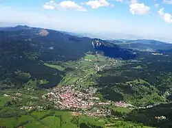 Aerial view | |
 Flag  Coat of arms | |
 Železná Ruda Location in the Czech Republic | |
| Coordinates: 49°8′28″N 13°13′48″E / 49.14111°N 13.23000°E | |
| Country | |
| Region | Plzeň |
| District | Klatovy |
| First mentioned | 1569 |
| Government | |
| • Mayor | Filip Smola |
| Area | |
| • Total | 79.76 km2 (30.80 sq mi) |
| Elevation | 771 m (2,530 ft) |
| Population (2023-01-01)[1] | |
| • Total | 1,681 |
| • Density | 21/km2 (55/sq mi) |
| Time zone | UTC+1 (CET) |
| • Summer (DST) | UTC+2 (CEST) |
| Postal code | 340 04 |
| Website | www |
Železná Ruda (Czech pronunciation: [ˈʒɛlɛznaː ˈruda], German: Markt Eisenstein) is a town in Klatovy District in the Plzeň Region of the Czech Republic. It has about 1,700 inhabitants. It is one of the important sports and tourist centres of the Bohemian Forest.
Administrative parts
Villages of Alžbětín, Debrník, Hojsova Stráž, Pancíř and Špičák are administrative parts of Železná Ruda.
Etymology
The town's name literally means "iron ore". It refers to rich deposits of iron ore that were found and mined here.[2] The German name of the town comes from the Middle Ages, when it was a market town.
Geography
Železná Ruda is located about 29 km (18 mi) south of Klatovy and 66 km (41 mi) south of Plzeň, on the border with Germany. It lies in a wild mountainous terrain of the Bohemian Forest. The town is surrounded with thick coniferous woods. The highest mountain in the municipal territory is Jezerní hora with an elevation of 1,344 m (4,409 ft). The southeastern part of the territory lies in the Šumava National Park, rest of the territory belongs to the Šumava Protected Landscape Area.
The Regen River springs on the southern slopes of Pancíř mountain and flows through the town proper to the German border. The Úhlava River springs on the western slopes of the same mountain and flows across the northern half of the municipal territory.
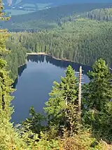
Černé jezero, the largest natural lake in the country and Čertovo jezero, the third largest lake, are located in the territory of Železný Brod.
Climate
The climate is cool and wet humid continental hemiboreal (Dfb) with moderately cold, long winters and cool summers. Average July temperature is 15.1 °C (59.2 °F) and average January temperature is −4.2 °C (24.4 °F). Yearly average is 5.7 °C (42.3 °F) and there is some 967 mm of precipitation.
| Climate data for Železná Ruda | |||||||||||||
|---|---|---|---|---|---|---|---|---|---|---|---|---|---|
| Month | Jan | Feb | Mar | Apr | May | Jun | Jul | Aug | Sep | Oct | Nov | Dec | Year |
| Mean daily maximum °C (°F) | −0.2 (31.6) |
1.2 (34.2) |
5.4 (41.7) |
11.5 (52.7) |
15.7 (60.3) |
18.9 (66.0) |
20.5 (68.9) |
20.5 (68.9) |
16.0 (60.8) |
11.5 (52.7) |
5.6 (42.1) |
1.1 (34.0) |
10.0 (50.0) |
| Daily mean °C (°F) | −3.1 (26.4) |
−2.3 (27.9) |
1.3 (34.3) |
6.6 (43.9) |
11.3 (52.3) |
14.8 (58.6) |
16.3 (61.3) |
16.2 (61.2) |
11.9 (53.4) |
7.6 (45.7) |
2.4 (36.3) |
−1.6 (29.1) |
6.8 (44.2) |
| Mean daily minimum °C (°F) | −6.0 (21.2) |
−5.6 (21.9) |
−2.7 (27.1) |
1.6 (34.9) |
6.5 (43.7) |
10.1 (50.2) |
11.8 (53.2) |
11.8 (53.2) |
8.0 (46.4) |
4.2 (39.6) |
−0.2 (31.6) |
−4.1 (24.6) |
1.4 (34.5) |
| Average precipitation mm (inches) | 74 (2.9) |
60 (2.4) |
76 (3.0) |
69 (2.7) |
102 (4.0) |
114 (4.5) |
119 (4.7) |
107 (4.2) |
82 (3.2) |
68 (2.7) |
69 (2.7) |
76 (3.0) |
1,016 (40.0) |
| Source: Climate-Data.org[3] | |||||||||||||
History
Železná Ruda was founded at the beginning of the 16th century as a mining town. After around 150 years, the iron ore stocks were extracted and iron production ended. Because quartz and limestone deposits were also located here, the town's industry reoriented to the glass industry. The first factory was built in 1624. The Alžbětín Glassworks was later one of the largest glassworks in the Bohemian Forest. In the second half of the 19th century, it was known mainly for plate glass.[2]
Between 1847 and 1877, the railway was built.[2]
Its German population was expelled after 1945.
Demographics
|
|
| ||||||||||||||||||||||||||||||||||||||||||||||||||||||
| Source: Censuses[4][5] | ||||||||||||||||||||||||||||||||||||||||||||||||||||||||
Economy
The local economy is very dependent on tourism because Železná Ruda is one of the most popular skiing centres of the Bohemian Forest, as well as a starting point for many hiking trips on both sides of the border. The town has also gained a reputation as a hotspot for prostitution shortly after the Velvet Revolution.[6]
Transport

The town is located on a train line leading from Plzeň and Klatovy to the border station at Železná Ruda-Alžbětín/Bayerisch Eisenstein. This station building is divided by the national border between the Czech Republic and Germany.
Sights

There are many nature sights, such as lakes Černé jezero and Čertovo jezero, and the Špičák mountain at 1,202 m (3,944 ft) above sea level. A railway tunnel goes under Špičák. The tunnel is 1,747 m (5,732 ft) long and it was the longest railway tunnel in the Czech Republic until 2007.
The most valuable historical monument is the Church of Our Lady of Perpetual Help of the Star. It was built in the Baroque style in 1729–1732. Its peculiarity is the floor plan of the six-pointed star and two cupolas with a star.[7] Other historical sights include the Chapel of Saints Anthony of Padua and Barbara, and the Stations of the Cross.
The local museum and information centre are located in a house from 1877, which was once the home of a well-known family of glassmakers. There is an exhibition of traditional glass, documents and photographs concerning history available all year round.[8]
Twin towns – sister cities
Železná Ruda is twinned with:[9]
 Aldeno, Italy
 Bayerisch Eisenstein, Germany
.svg.png.webp) Zernez, Switzerland
Zernez, Switzerland
References
- ↑ "Population of Municipalities – 1 January 2023". Czech Statistical Office. 2023-05-23.
- 1 2 3 "Historie Železné Rudy" (in Czech). Železná Ruda. Retrieved 2021-06-11.
- ↑ "Climate Železná Ruda". Climate-Data.org. 11 December 2013.
- ↑ "Historický lexikon obcí České republiky 1869–2011 – Okres Klatovy" (in Czech). Czech Statistical Office. 2015-12-21. pp. 31–32.
- ↑ "Population Census 2021: Population by sex". Public Database. Czech Statistical Office. 2021-03-27.
- ↑ Skala, Jan (2 April 2012). "Vykřičené domy pomalu mizí, prostitutky končí s živností". Deník.cz (in Czech).
- ↑ "Kostel Panny Marie Pomocné z hvězdy" (in Czech). Město Železná Ruda. Retrieved 2022-01-24.
- ↑ "Muzeum Šumavy Železná Ruda" (in Czech). CzechTourism. Retrieved 2022-01-24.
- ↑ "Železnorudský zpravodaj – srpen 2018" (PDF) (in Czech). Železná Ruda. August 2018. pp. 1, 11. Retrieved 2020-07-27.