| Mabamba Bay | |
|---|---|
.jpg.webp) | |
 Mabamba Bay | |
| Coordinates | 0°5′N 32°20′E / 0.083°N 32.333°E |
| Basin countries | Uganda |
| Surface area | 16,500 hectares (64 sq mi) |
| Surface elevation | 1,130 metres (3,710 ft) |
| Official name | Mabamba Bay Wetland System |
| Designated | 15 September 2006 |
| Reference no. | 1638[1] |
Mabamba Bay is a wetland on the edge of Lake Victoria, northwest of the Entebbe peninsula.
Conservation
Mabamba is one of Uganda's 33 Important Bird Areas and since 2006 a Ramsar-listed wetland of international importance.[2] Key protected bird species in Mabamba are the shoebill, the blue swallow and the papyrus gonolek.[3]
 Uganda's Iconic Shoebill Stork in Mabamba Wetland
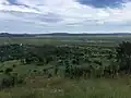 Wetlands after heavy rain
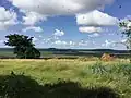 View of Mabamba bay from nearby hill
References
- ↑ "Mabamba Bay Wetland System". Ramsar Sites Information Service. Retrieved 25 April 2018.
- ↑ Ramsar Convention on Wetlands. "The Annotated Ramsar List: Uganda". Archived from the original on 7 January 2013. Retrieved 28 June 2012.
- ↑ Byaruhanga, Achilles; Kasoma, Pantaleon; Pomeroy, Derek. "Uganda" (PDF). Country Profiles. BirdLife International. Retrieved 16 August 2013.
Wikimedia Commons has media related to Mabamba Bay Wetland System.
This article is issued from Wikipedia. The text is licensed under Creative Commons - Attribution - Sharealike. Additional terms may apply for the media files.