 | ||||
|---|---|---|---|---|
| Федеральная автомобильная дорога М7 | ||||
| Volga Highway | ||||
 | ||||
| Route information | ||||
| Part of | ||||
| Length | 1,342 km (834 mi) | |||
| Major junctions | ||||
| West end | ||||
| East end | R240 in Ufa | |||
| Location | ||||
| Country | Russia | |||
| Highway system | ||||
| ||||
The Russian Route M7 (also known as the Volga Highway) is a major trunk road running from Moscow through Vladimir and Nizhny Novgorod to Kazan in Tatarstan and Ufa in Bashkortostan. It generally follows the route of the historic Vladimirka road and, to a large extent, forms part of the European route E22. The section from Yelabuga to Ufa is also part of European route E017.
In 1 November 2023, Russian Federal Government announced to shorten the M7 highway to Kazan[1], by 31 December 2024, the cutted section will be altered to parts of M12 from Shali, Kazan to Diltuli; R240 from Diltuli to Ufa; and R243 for the branch section to either Izhevsk or Perm.[2]
Major junctions
| Federal subject | District | Location | km | Destinations | Notes |
|---|---|---|---|---|---|
| Moscow | 16 | Moscow Ring Road | Interchange | ||
| Moscow Oblast | Obukhovo | 43 | Interchange is under construction[3] | ||
| Bogorodsky | 53 | Interchange | |||
| 62 | Interchange | ||||
| 84 | Interchange | ||||
| Vladimir Oblast | Sobinsky | 165 | 17A-2 – Koloksha, Dvoriki | ||
| Sudogodsky | 189 | Interchange | |||
| Kovrovsky | 246 | 17K-1 – Seninskiye Dvoriki, Kovrov, Shuya, Kineshma | |||
| Gorokhovetsky | 324 | 17K-2 – Murom, Muromsky Zakaznik | |||
| Nizhny Novgorod Oblast | Dzerzhinsk | 399 | 22K-0101 – Nizhny Novgorod | Interchange | |
| ? | 22N-5018 – Strigino Airport | Interchange | |||
| ? | |||||
| ? | 22K-0007 | ||||
| 472 | 22K-0162 | ||||
Route
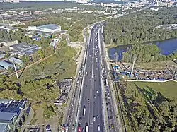
M7 highway in Balashikha, Moscow Oblast.

M7 highway in Lezhnevsky District of Ivanovo Oblast.

- 0 km — Moscow Ring Road
- 35 km — Elektrostal and Noginsk
- 65 km — Malaya Dubna near Orekhovo-Zuyevo
- Vladimir Oblast
- 81 km — Pokrov
- 130 km — Lakinsk
- 158 km — Yuryevets
- 162 km — Vladimir
- 225 km — a branch to Kovrov
- 273 km — Vyazniki
- 313 km — Gorokhovets
- Nizhny Novgorod Oblast
- 397 km — crossing the Oka River in Nizhny Novgorod (over the Myza Bridge)
- 430 km — Kstovo
- 463 km — Rabotki
- 491 km — Lyskovo
- 544 km — Vorotynets
- Chuvash Republic
- 634 km — crossing the Vyatka Highway in Cheboksary
- 679 km — Tsivilsk
- Tatarstan
- 761 km — crossing the Volga River in Zelenodolsk
- 809 km — Kazan
- 969 km — crossing the Vyatka River in Mamadysh
- 1024 km — Yelabuga
- 1044 km — crossing the Kama River in Naberezhnye Chelny
- Bashkortostan
- 1134 km — Verkhneyarkeyevo
- 1230 km — Kushnarenkovo
- 1280 km — Ufa, M5
Gallery
![A bridge over Koltymak River [ru] in Alnashsky District of the Udmurt Republic.](../I/%D0%9C-7_%C2%AB%D0%92%D0%BE%D0%BB%D0%B3%D0%B0%C2%BB%252C_%D0%BF%D0%BE%D0%B4%D1%8A%D0%B5%D0%B7%D0%B4_%D0%BA_%D0%98%D0%B6%D0%B5%D0%B2%D1%81%D0%BA%D1%83%252C_42_%D0%BA%D0%BC%252C_%D0%BC%D0%BE%D1%81%D1%82_%D1%87%D0%B5%D1%80%D0%B5%D0%B7_%D1%80%D0%B5%D0%BA%D1%83_%D0%9A%D0%BE%D0%BB%D1%82%D1%8B%D0%BC%D0%B0%D0%BA_%C2%B7_1.jpg.webp) A bridge over Koltymak River in Alnashsky District of the Udmurt Republic.
A bridge over Koltymak River in Alnashsky District of the Udmurt Republic.
![The Zaymishchensky bridge [ru] of the M7 highway in Tatarstan.](../I/%D0%9C-7_%C2%AB%D0%92%D0%BE%D0%BB%D0%B3%D0%B0%C2%BB%252C_777-%D0%B9_%D0%BA%D0%BC%252C_%D0%BC%D0%BE%D1%81%D1%82_%D1%87%D0%B5%D1%80%D0%B5%D0%B7_%D0%92%D0%BE%D0%BB%D0%B3%D1%83_%D0%B2_%D0%A2%D0%B0%D1%82%D0%B0%D1%80%D1%81%D1%82%D0%B0%D0%BD%D0%B5_(%D0%97%D0%B0%D0%B9%D0%BC%D0%B8%D1%89%D0%B5%D0%BD%D0%BA%D0%B8%D0%B9_%D0%BC%D0%BE%D1%81%D1%82)_%C2%B7_2.jpg.webp) The Zaymishchensky bridge of the M7 highway in Tatarstan.
The Zaymishchensky bridge of the M7 highway in Tatarstan..jpg.webp) M7 highway in Tatarstan (807th km)
M7 highway in Tatarstan (807th km)![M7 highway in the area of the hamlet of Andreyevo-Bazary [ru] in Chuvashia.](../I/%D0%9C-7_%C2%AB%D0%92%D0%BE%D0%BB%D0%B3%D0%B0%C2%BB%252C_%D1%83%D1%87%D0%B0%D1%81%D1%82%D0%BE%D0%BA_%D1%81_698_%D0%BF%D0%BE_705_%D0%BA%D0%BC_%D0%BF%D0%BE%D1%81%D0%BB%D0%B5_%D1%80%D0%B5%D0%BA%D0%BE%D0%BD%D1%81%D1%82%D1%80%D1%83%D0%BA%D1%86%D0%B8%D0%B8_%C2%B7_1.jpg.webp) M7 highway in the area of the hamlet of Andreyevo-Bazary in Chuvashia.
M7 highway in the area of the hamlet of Andreyevo-Bazary in Chuvashia.
References
- ↑ "О внесении изменений в постановление Правительства РоссийскойФедерации от 17 ноября 2010 г. № 928" (PDF) (in Russian). 2023-10-01. Retrieved 2024-01-13.
{{cite web}}: CS1 maint: url-status (link) - ↑ "проекту постановления Правительства РФ".
{{cite web}}:|archive-date=requires|archive-url=(help)CS1 maint: url-status (link) - ↑ "Строительство развязки на трассе М7 в подмосковном пос. Обухово планируют завершить в конце 2020 г." news.rambler.ru (in Russian). Retrieved 24 May 2020.
This article is issued from Wikipedia. The text is licensed under Creative Commons - Attribution - Sharealike. Additional terms may apply for the media files.