North Luwu Regency
Kabupaten Luwu Utara | |
|---|---|
|
Coat of arms | |
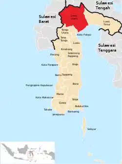 Location within South Sulawesi | |
| Country | Indonesia |
| Province | South Sulawesi |
| Capital | Masamba |
| Government | |
| • Regent | Indah Putri Indriani |
| Area | |
| • Total | 7,502.58 km2 (2,896.76 sq mi) |
| Population (mid 2022 estimate)[1] | |
| • Total | 327,820 |
| • Density | 44/km2 (110/sq mi) |
| Time zone | UTC+7 (WIB) |
| Area code | +62 473 |
North Luwu Regency is a regency of South Sulawesi Province of Indonesia. It was created on 20 April 1999 by separation of the province's northern districts formerly within the Luwu Regency; however on 25 February 2003 it was reduced when the easternmost of these same districts were split off to create the East Luwu Regency. It now covers 7,502.58 km2 and had a population of 287,606 at the 2010 census[2] and 322,919 at the 2020 census;[3] the official estimate as at mid 2022 was 327,820 (comprising 165,682 males and 162,138 females ).[1] The principal town lies at Masamba.
Administrative districts
North Luwu Regency in 2010 comprised eleven administrative Districts (Kecamatan), but subsequently four further districts have been added by the division of existing districts. These fifteen districts are tabulated below with their areas and their populations at the 2010 census[2] and the 2020 census,[3] together with the official estimates as at mid 2022.[1] The table also includes the locations of the district administrative centres, the numbers of administrative villages in each district (totalling 7 urban kelurahan and 166 rural desa), and its post code.
| Kode Wilayah | Name of District (kecamatan) | Area in km2 | Pop'n census 2010 | Pop'n census 2020 | Pop'n estimate mid 2022 | Admin centre | No. of villages | Post code |
|---|---|---|---|---|---|---|---|---|
| 73.22.04 | Sabbang | 424.11 | 34,839 | 18,008 | 18,198 | Marobo | 10 (a) | 92955 |
| 73.22.15 | Sabbang Selatan (South Sabbang) | 100.97 | (b) | 22,227 | 22,861 | Boangin | 10 | 92955 |
| 73.22.11 | Baebunta | 203.16 | 43,068 | 31,798 | 32,223 | Salassa | 11 (a) | 92965 |
| 73.22.14 | Baebunta Selatan (South Baebunta) | 92.09 | (c) | 16,005 | 16,174 | Lara | 10 | 92965 |
| 73.22.01 | Malangke | 229.70 | 27,005 | 28,852 | 28,996 | Tolada | 14 | 92953 |
| 73.22.08 | Malangke Barat (West Malangke) | 214.05 | 23,512 | 25,014 | 25,118 | Pao / Ammassangan | 13 | 92957 |
| 73.22.06 | Sukamaju | 208.21 | 40,780 | 27,965 | 28,457 | Sulamaju | 14 | 92963 |
| 73.22.13 | Sukamaju Selatan (South Sukamaju) | 47.27 | (d) | 18,031 | 18,256 | Mulyorejo | 11 | 92963 |
| 73.22.02 | Bone-Bone | 127.92 | 45,862 | 27,597 | 28,037 | Bone-Bone | 11 (a) | 92966 |
| 73.22.12 | Tanalili | 149.41 | (e) | 24,713 | 25,204 | Bungapati | 10 | 92967 |
| 73.22.03 | Masamba | 1,068.85 | 31,237 | 38,024 | 39,152 | Kappuna | 19 (f) | 92961 (g) |
| 73.22.10 | Mappedeceng | 275.50 | 21,925 | 24,713 | 25,104 | Cendana Putih II | 15 | 92917 |
| 73.22.09 | Rampi | 1,565.65 | 2,860 | 3,124 | 3,153 | Onondowa | 6 | 92964 |
| 73.22.05 | Limbong (or Rongkong) | 686.50 | 3,824 | 3,843 | 3,865 | Limbong | 7 | 92954 |
| 73.22.07 | Seko | 2,109.19 | 12,560 | 12,997 | 13,022 | Padang Balua | 12 | 92956 |
| Totals | 7,502.58 | 287,606 | 322,919 | 327,820 | Masamba | 173 |
Notes: (a) including one kelurahan (the district administrative centre)
(b) the 2010 population of the new Sabbang Selatan District is included in the figure for Selatan District.
(c) the 2010 population of the new Baebunta Selatan District is included in the figure for Baebunta District.
(d) the 2010 population of the new Sukamaju Selatan District is included in the figure for Sukamaju District.
(e) the 2010 population of the new Tanalili District is included in the figure for Bone-Bone District.
(f) including four kelurahan (named in next line) and 15 desa. (g) except for
the desa of Balebo (or Baloli) which has a post code of 92912, and the kelurahan of Kappuna (post code 91913), Bone (92914), Kasimbong (92915) and Baliase (92916).
References
Regencies and cities of South Sulawesi | ||
|---|---|---|
Capital: Makassar | ||
| Regencies |  | |
| Cities | ||
2°36′S 120°15′E / 2.600°S 120.250°E