Lone Pine Airport | |||||||||||||||
|---|---|---|---|---|---|---|---|---|---|---|---|---|---|---|---|
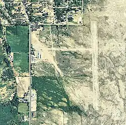
 2006 USGS airphoto | |||||||||||||||
| Summary | |||||||||||||||
| Airport type | Public | ||||||||||||||
| Location | Lone Pine, California | ||||||||||||||
| Elevation AMSL | 3,680 ft / 1,122 m | ||||||||||||||
| Coordinates | 36°35′17.760″N 118°03′07.31″W / 36.58826667°N 118.0520306°W | ||||||||||||||
| Map | |||||||||||||||
 O26 Location of Lone Pine Airport | |||||||||||||||
| Runways | |||||||||||||||
| |||||||||||||||
Lone Pine Airport (FAA LID: O26) is a public airport located one mile (1.6 km) southeast of Lone Pine (geographic coordinates N36-35.30; W118-03.12) serving Inyo County, California, United States. The airport has two runways and is mostly used for general aviation. Charts: San Francisco; L5.
Facilities
Lone Pine Airport has two runways:
- Runway 16/34: 4,000 x 60 ft (1,219 x 18 m), surface: asphalt
- Runway 13/31: 2,400 x 100 ft (732 x 30 m), surface: dirt
World War II
During World War II, the airport was used as a contract flying school by the United States Army Air Forces. The school operated between 1942 and 1944. It also controlled several auxiliary airfields:
See also
References
![]() This article incorporates public domain material from the Air Force Historical Research Agency
This article incorporates public domain material from the Air Force Historical Research Agency
Wikimedia Commons has media related to Lone Pine Airport.
- Airport Master Record (FAA Form 5010) Archived 2007-01-30 at the Wayback Machine, also available as a printable form (PDF)
External links
- Resources for this airport:
- FAA airport information for O26
- AirNav airport information for O26
- FlightAware airport information and live flight tracker
- SkyVector aeronautical chart for O26
This article is issued from Wikipedia. The text is licensed under Creative Commons - Attribution - Sharealike. Additional terms may apply for the media files.
