This table shows an overview of the protected heritage sites in the Walloon town Trooz. This list is part of Belgium's national heritage.
| Object | Year/architect | Town/section | Address | Coordinates | Number? | Image |
|---|---|---|---|---|---|---|
| The square of the village Forêt (nl) (fr) |
Trooz | 50°35′02″N 5°41′58″E / 50.583886°N 5.699443°E |
62122-CLT-0001-01 Info |
|||
| Church of Sainte-Catherine (nl) (fr) |
Trooz | 50°35′03″N 5°42′02″E / 50.584228°N 5.700637°E |
62122-CLT-0002-01 Info |
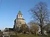 Kerk ('Sainte-Catherine') | ||
| Area of special value ("Site des Fonds de Forêt ') (nl) (fr) |
Trooz | 50°35′27″N 5°41′34″E / 50.590943°N 5.692879°E |
62122-CLT-0003-01 Info |
|||
| Monument-crypt to commemorate victims of the resistance of the tragedy of Forêt-Trooz, town square and the ensemble of the monument and its surroundings (nl) (fr) |
Trooz | 50°35′01″N 5°41′54″E / 50.583691°N 5.698357°E |
62122-CLT-0004-01 Info |
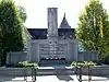 Monument-crypte ter nagedachtenis aan slachtoffers van de weerstand van de tragedie van Forêt-Trooz, dorpsplein en het ensemble van het monument en diens omgeving | ||
| The castle of Fenderie (nl) (fr) |
Trooz | rue de la Fenderie, n°5 (M) et ensemble formé par ce castel et les terrains environnants (S) | 50°34′16″N 5°41′27″E / 50.571228°N 5.690963°E |
62122-CLT-0005-01 Info |
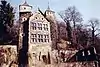 Het kasteel van Fenderie | |
| Organs of the church of Saint-Gilles (nl) (fr) |
Trooz | 50°33′56″N 5°43′27″E / 50.565575°N 5.724285°E |
62122-CLT-0006-01 Info |
|||
| Nature of Massouheid (nl) (fr) |
Trooz | 50°34′32″N 5°42′18″E / 50.575483°N 5.705039°E |
62122-CLT-0007-02 Info |
|||
| Nature of Massouheid (extension) (nl) (fr) |
Trooz | 50°34′25″N 5°42′16″E / 50.573584°N 5.704499°E |
62122-CLT-0008-01 Info |
|||
| Facades, roofs and windows of the main building and the adjacent outbuilding with oldest remnants in the Fonds-de-Forêt (nl) (fr) |
Trooz | 50°35′32″N 5°41′46″E / 50.592178°N 5.696122°E |
62122-CLT-0010-01 Info |
|||
| The front bounded on the left by the semi-hexagonal tower of the castle and bounded on the right by a part of the facade below the entrance of the old factory Imperia (nl) (fr) |
Trooz | 50°34′26″N 5°44′39″E / 50.574020°N 5.744194°E |
62122-CLT-0011-01 Info |
|||
| Area of special value ("Le site des Fonds de Forêt ') (nl) (fr) |
Trooz | 50°35′27″N 5°41′34″E / 50.590943°N 5.692879°E |
62122-PEX-0001-01 Info |
See also
Wikimedia Commons has media related to Cultural heritage monuments in Trooz.
References
- Belgian heritage register: Direction générale opérationnelle - Aménagement du territoire, Logement, Patrimoine et Energie (DG4)
- www.dglive.be
This article is issued from Wikipedia. The text is licensed under Creative Commons - Attribution - Sharealike. Additional terms may apply for the media files.