This table shows an overview of the protected heritage sites in the Walloon town Opzullik, or Silly, Belgium. This list is part of Belgium's national heritage.
| Object | Year/architect | Town/section | Address | Coordinates | Number? | Image |
|---|---|---|---|---|---|---|
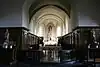
| Valley on the southwest edge of the forest Cambron at a place called "L'Ermitage" (nl) (fr) |
Opzullik | Silly | 50°37′16″N 3°57′44″E / 50.621160°N 3.962099°E |
55039-CLT-0002-01 Info |
||
| The oldest parts, namely the ship, the nave and the tower of the church of Bassilly and the ensemble of this church, the cemetery, the avenue of lime trees and the enclosing wall (nl) (fr) |
Opzullik | 50°40′22″N 3°56′11″E / 50.672705°N 3.936459°E |
55039-CLT-0003-01 Info |
|||
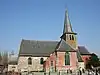
| Church of Saint-Amand (nl) (fr) |
Opzullik | Hellebecq | 50°39′47″N 3°53′20″E / 50.663181°N 3.889000°E |
55039-CLT-0004-01 Info |
.JPG.webp) Kerk Saint-Amand | |
| the church of St. Maurice (nl) (fr) |
Opzullik | Hoves | 50°40′14″N 4°02′07″E / 50.670622°N 4.035146°E |
55039-CLT-0005-01 Info |
 Kerk Saint-Martin | |
| Site formed by the church of Saint-Maurice, the cemetery and the old wall that surrounds this (nl) (fr) |
Opzullik | Hoves | 50°40′13″N 4°02′05″E / 50.670280°N 4.034588°E |
55039-CLT-0006-01 Info |
 Site gevormd door de kerk Saint-Maurice, het kerkhof en de oude muur die deze omringt | |
| The motte located near the castle and the church of Silly (nl) (fr) |
Opzullik | 50°40′15″N 4°02′05″E / 50.670716°N 4.034790°E |
55039-CLT-0007-01 Info |
|||
| The facade and roof of the castle of Thoricourt, outbuildings and orangerie, interior and exterior of the chapel, the pillory (M) and the ensemble of the castle and surrounding park (nl) (fr) |
Opzullik | 50°37′02″N 3°57′11″E / 50.617151°N 3.952994°E |
55039-CLT-0008-01 Info |
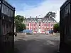 De gevel en daken van het kasteel van Thoricourt, bijgebouwen en de oranjerie, interieur en exterieur van de kapel, de schandpaal (M) en het ensemble van het kasteel en de omliggende park | ||
| Tower of the castle of Launois (nl) (fr) |
Opzullik | Silly | 50°36′51″N 3°57′34″E / 50.614259°N 3.959369°E |
55039-CLT-0010-01 Info |
||
| The old buildings at the entrance to the grounds of the castle of Enghien, including the old stables, pavilion Edward, the door of the slaves, the chapel and the pavilion called "Pavillon des Sept Etoiles" and the ensemble of the castle , the outbuildings and the adjacent land (nl) (fr) |
Opzullik | 50°41′32″N 4°02′27″E / 50.692184°N 4.040844°E |
55039-CLT-0013-01 Info |
|||
| The Pavillon des Sept Etoiles and the park of Arenberg castle, except the golf course (nl) (fr) |
Opzullik | 50°41′16″N 4°02′50″E / 50.687656°N 4.047325°E |
55039-PEX-0001-01 Info |
See also
Wikimedia Commons has media related to Cultural heritage monuments in Silly, Belgium.
References
- Belgian heritage register: Direction générale opérationnelle - Aménagement du territoire, Logement, Patrimoine et Energie (DG4)
- www.dglive.be
This article is issued from Wikipedia. The text is licensed under Creative Commons - Attribution - Sharealike. Additional terms may apply for the media files.