This table shows an overview of the protected heritage sites in the Walloon town Raeren. This list is part of Belgium's national heritage.
| Object | Year/architect | Town/section | Address | Coordinates | Number | Image |
|---|---|---|---|---|---|---|
| Eynatten village center (nl) (de) |
Raeren | 50°41′35″N 6°04′47″E / 50.692993°N 6.079779°E | 31450 Info | _31.jpg.webp) Eynatten village center | ||
| St. Roch Chapel and surroundings (nl) (de) |
Raeren | 50°42′05″N 6°03′51″E / 50.701402°N 6.064134°E | 31383 Info | 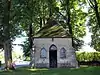 St. Roch Chapel and surroundings | ||
| Cross "Hauseter Feld" (nl) (de) |
Raeren | 50°41′45″N 6°03′14″E / 50.695813°N 6.053890°E | 31384 Info | .JPG.webp) Cross "Hauseter Feld" | ||
| Zyklopensteine with surroundings (nl) (de) |
Raeren | 50°43′13″N 6°05′40″E / 50.720194°N 6.094579°E | 31434 Info | 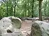 Zyklopensteine with surroundings | ||
| St. Nicholas Church (nl) (de) |
Raeren | 50°40′33″N 6°06′39″E / 50.675818°N 6.110876°E | 31385 Info | .JPG.webp) St. Nicholas Church | ||
| St. Anne Chapel (nl) (de) |
Raeren | 50°40′41″N 6°07′32″E / 50.677985°N 6.125515°E | 31398 Info | 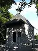 St. Anne Chapel | ||
| Cross "Kule Kreuz" (nl) (de) |
Raeren | 50°40′31″N 6°06′39″E / 50.675275°N 6.110727°E | 31449 Info | 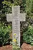 Cross "Kule Kreuz" | ||
| Raeren Castle: tower and north wall with gate (nl) (de) |
Raeren | 50°40′43″N 6°07′14″E / 50.678749°N 6.120609°E | 31399 Info | 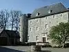 Raeren Castle: tower and north wall with gate | ||
| Raeren house: walls, roof, moat and bridge (nl) (de) |
Raeren | 50°40′41″N 6°07′19″E / 50.678182°N 6.121958°E | 31400 Info | .JPG.webp) Raeren house: walls, roof, moat and bridge | ||
| Amstenrath house and farm buildings (facades and roofs) and the cobblestone courtyard (nl) (de) |
Raeren | 50°41′40″N 6°04′56″E / 50.694392°N 6.082290°E | 31369 Info | .JPG.webp) Amstenrath house and farm buildings (facades and roofs) and the cobblestone courtyard | ||
| "Hohe Brücke" area (nl) (de) |
Raeren | 50°40′39″N 6°07′06″E / 50.677405°N 6.118226°E | 31404 Info | .JPG.webp) "Hohe Brücke" area | ||
| Knoppenburg: two round towers, facades and roofs of the west wing and east wing, walls and roof of the residential building (except the two adjoining buildings on either side) and surroundings (nl) (de) |
Raeren | 50°40′02″N 6°05′58″E / 50.667161°N 6.099568°E | 31401 Info | .JPG.webp) Knoppenburg: two round towers, facades and roofs of the west wing and east wing, walls and roof of the residential building (except the two adjoining buildings on either side) and surroundings | ||
| House: walls and roof (nl) (de) |
Raeren | Lichtenbuscher Strasse 19 | 50°41′35″N 6°05′05″E / 50.693191°N 6.084757°E | 31371 Info | .JPG.webp) House: walls and roof | |
| "Der Vennbusch" (nl) (de) |
Raeren | 50°39′41″N 6°07′12″E / 50.661251°N 6.120078°E | 31058 Info | .JPG.webp) "Der Vennbusch" | ||
| Hof Meurisse: walls, roofs, and cobblestone courtyard (nl) (de) |
Raeren | 50°40′52″N 6°08′34″E / 50.681068°N 6.142895°E | 31402 Info | .JPG.webp) Hof Meurisse: walls, roofs, and cobblestone courtyard | ||
| House: walls and roof, fence wall with blue stone pillars and wrought iron gate (nl) (de) |
Raeren | Eupener Strasse 8 | 50°41′31″N 6°04′57″E / 50.691991°N 6.082626°E | 31376 Info | 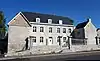 House: walls and roof, fence wall with blue stone pillars and wrought iron gate | |
| Bergschied house: walls and roof of the main house and entrance gate (nl) (de) |
Raeren | 50°40′17″N 6°07′00″E / 50.671330°N 6.116574°E | 31403 Info | .JPG.webp) Bergschied house: walls and roof of the main house and entrance gate | ||
| Raaff Castle: The ruins of the tower (nl) (de) |
Raeren | Berlotte | 50°41′52″N 6°06′09″E / 50.697840°N 6.102505°E | 31381 Info | 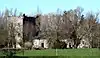 Raaff Castle: The ruins of the tower | |
| Court Stester: walls and roofs (nl) (de) |
Raeren | Berlotte | 50°41′56″N 6°06′22″E / 50.698752°N 6.106124°E | 31382 Info | .JPG.webp) Court Stester: walls and roofs | |
| Brandheidchen (nl) (de) |
Raeren | 50°42′15″N 6°04′24″E / 50.704086°N 6.073438°E | 31057 Info | .JPG.webp) Brandheidchen | ||
| Der Leuff: walls and roof, and the stables: facades and roof (nl) (de) |
Raeren | 50°41′32″N 6°04′59″E / 50.692260°N 6.083049°E | 32237 Info | .jpg.webp) Der Leuff: walls and roof, and the stables: facades and roof | ||
| Saxby signal-box of former train station including the station and technical equipment (de) |
Raeren | 50°39′52″N 6°07′33″E / 50.664464°N 6.125862°E | 40366 Info | _2.jpg.webp) Saxby signal-box of former train station including the station and technical equipment |
See also
- Lists of protected heritage sites in the German-speaking Community of Belgium
- List of protected heritage sites in Liège (province)
- Raeren
Wikimedia Commons has media related to Cultural heritage monuments in Raeren.
References
- Belgian heritage register: Direction générale opérationnelle - Aménagement du territoire, Logement, Patrimoine et Energie (DG4)
- www.dglive.be
- Geschützte Objekte in Raeren
This article is issued from Wikipedia. The text is licensed under Creative Commons - Attribution - Sharealike. Additional terms may apply for the media files.