This table shows an overview of the protected heritage sites in the Walloon town Pepinster. This list is part of Belgium's national heritage.
| Object | Year/architect | Town/section | Address | Coordinates | Number? | Image |
|---|---|---|---|---|---|---|
| Sclassin Castle: walls and roofs, and the surrounding area (nl) (fr) |
Pepinster | 50°35′22″N 5°48′12″E / 50.589397°N 5.803293°E |
63058-CLT-0001-01 Info |
|||
| Roman fortifications of Becoën (nl) (fr) |
Pepinster | 50°33′47″N 5°46′25″E / 50.562940°N 5.773603°E |
63058-CLT-0002-01 Info |
|||
| 17th century house: walls and roofs (nl) (fr) |
Pepinster | rue du Centre, n°32 | 50°35′33″N 5°47′24″E / 50.592368°N 5.789902°E |
63058-CLT-0003-01 Info |
||
| Chapel Notre-Dame Débonnaire de Saint-Roch (nl) (fr) |
Pepinster | 50°35′30″N 5°48′40″E / 50.591687°N 5.811073°E |
63058-CLT-0006-01 Info |
|||
| Church of Saint-Roch, including the tower and the walled cemetery (nl) (fr) |
Pepinster | 50°35′33″N 5°47′27″E / 50.592470°N 5.790873°E |
63058-CLT-0007-01 Info |
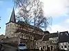 Kerk Saint-Roch, waaronder de toren en het ommuurde kerkhof | ||
| The towers of Soiron castle (nl) (fr) |
Pepinster | 50°35′36″N 5°47′24″E / 50.593345°N 5.789984°E |
63058-CLT-0008-01 Info |
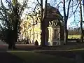 De torens van het kasteel van Soiron | ||
| Soiron castle, except the towers classified by Royal Decree on 30 November 1960, and the park area (nl) (fr) |
Pepinster | 50°35′37″N 5°47′22″E / 50.593735°N 5.789570°E |
63058-CLT-0009-01 Info |
Kasteel van Soiron, uitgezonderd de geclassificeerde torens per Koninklijk Besluit op 30 november 1960, en het ensemble van het kasteel, het park en de omgeving | ||
| Moraithier Forest (nl) (fr) |
Pepinster | 50°35′35″N 5°47′24″E / 50.593048°N 5.790042°E |
63058-CLT-0010-01 Info |
|||
| House (nl) (fr) |
Pepinster | rue du Village, n°30-31 | 50°35′33″N 5°47′25″E / 50.592399°N 5.790209°E |
63058-CLT-0011-01 Info |
||
| Pastorage (nl) (fr) |
Pepinster | rue du Village, n°90 | 50°35′27″N 5°47′27″E / 50.590957°N 5.790715°E |
63058-CLT-0012-01 Info |
||
| "Le Vieux Bon Dieu de Tancrémont" Cross (nl) (fr) |
Pepinster | 50°33′06″N 5°46′58″E / 50.551563°N 5.782855°E |
63058-CLT-0013-01 Info |
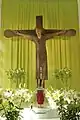 Kruis met de naam "le Vieux Bon Dieu de Tancrémont" | ||
| Station: window (nl) (fr) |
Pepinster | place Albert Ier | 50°34′06″N 5°48′24″E / 50.568254°N 5.806782°E |
63058-CLT-0015-01 Info |
.jpg.webp) Station: raam | |
| Parts of old farmhouses: façades, roofs, and staircases of numbers 78-80 and paved footpath to the front and rear of 80 A (nl) (fr) |
Pepinster | rue du Centre n°80 | 50°35′30″N 5°47′27″E / 50.591798°N 5.790914°E |
63058-CLT-0017-01 Info |
||
| Church of Saint-Antoine l'Ermite: exterior and interior, including furnishings (nl) (fr) |
Pepinster | rue Neuve 3 | 50°34′05″N 5°48′10″E / 50.567924°N 5.802904°E |
63058-CLT-0018-01 Info |
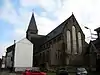 Totaliteit van de kerk Saint-Antoine l'Ermite: interieur en exterieur, waaronder het meubilair | |
| Valley of Fierain (nl) (fr) |
Pepinster | 50°35′20″N 5°49′25″E / 50.588939°N 5.823503°E |
63058-CLT-0019-01 Info |
|||
| Eight border markers of the Marquis of Franchimont in Liege and Louveigné, principality of Stavelot (nl) (fr) |
Pepinster | 50°31′42″N 5°45′32″E / 50.528216°N 5.758792°E |
63058-CLT-0020-01 Info |
See also
Wikimedia Commons has media related to Cultural heritage monuments in Pepinster.
References
- Belgian heritage register: Direction générale opérationnelle - Aménagement du territoire, Logement, Patrimoine et Energie (DG4)
- www.dglive.be
This article is issued from Wikipedia. The text is licensed under Creative Commons - Attribution - Sharealike. Additional terms may apply for the media files.