This table shows an overview of the protected heritage sites in the Walloon town Huy. This list is part of Belgium's national heritage.
| Object | Year/architect | Town/section | Address | Coordinates | Number? | Image |
|---|---|---|---|---|---|---|
| abbey of Alne (old pilgrim shelter) (nl) (fr) |
Huy | rue du Vieux Pont n° 2 | 50°31′11″N 5°14′00″E / 50.519855°N 5.233289°E |
61031-CLT-0006-01 Info |
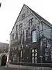 Onderdak van de abdij van Alne | |
| Agricultural Schoolhouse called "le ponton" (nl) (fr) |
Huy | rue St-Victor, n°5 | 50°31′09″N 5°13′35″E / 50.519078°N 5.226318°E |
61031-CLT-0008-01 Info |
||
| Old Franciscan monastery (nl) (fr) |
Huy | Rue Vankeerberghen n° 20 | 50°31′07″N 5°14′36″E / 50.518746°N 5.243391°E |
61031-CLT-0009-01 Info |
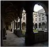 Oud klooster van de Minderbroeders | |
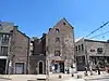
| house "du Gouverneur" (nl) (fr) |
Huy | rue Vankeerberghen n° 14 | 50°31′08″N 5°14′34″E / 50.518881°N 5.242741°E |
61031-CLT-0010-01 Info |
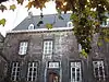 Huis genaamd "du Gouverneur" | |
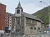
| Collegiate Church of Notre-Dame (nl) (fr) |
Huy | 50°31′08″N 5°14′17″E / 50.518824°N 5.238167°E |
61031-CLT-0011-01 Info |
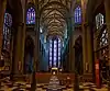 Collegiale kerk Notre-Dame | ||
| Church St-Mort (nl) (fr) |
Huy | 50°30′48″N 5°14′23″E / 50.513422°N 5.239825°E |
61031-CLT-0012-01 Info |
 Kerk St-Mort | ||
| Old church of Statte and its walls along the local way of the cross, the old cemetery, the church and the road "Chemin de Messe" (nl) (fr) |
Huy | 50°31′51″N 5°13′14″E / 50.530832°N 5.220538°E |
61031-CLT-0013-01 Info |
 Oude kerk van Statte en muren langs de chemin de Messe, en het ensemble van de voormalige calvarie van Statte, de oude begraafplaats, de kerk en de weg chemin de Messe | ||
| Thier de Statte Stations of the cross (nl) (fr) |
Huy | 50°31′54″N 5°13′14″E / 50.531625°N 5.220689°E |
61031-CLT-0014-01 Info |
 Calvarie van Thier de Statte | ||
| Old church of Saint-Mengold (nl) (fr) |
Huy | 50°31′06″N 5°14′31″E / 50.518258°N 5.241912°E |
61031-CLT-0015-01 Info |
 Oude kerk van Saint-Mengold | ||
| House, called Tour d'Oultremont (nl) (fr) |
Huy | rue du Palais de Justice n°7 | 50°31′10″N 5°14′35″E / 50.519365°N 5.243006°E |
61031-CLT-0016-01 Info |
 Huis, genaamd Tour d'Oultremont | |
| The old fountain on the market called BASSINIA (nl) (fr) |
Huy | 50°31′05″N 5°14′27″E / 50.518074°N 5.240894°E |
61031-CLT-0017-01 Info |
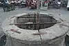 De monumentale fontein op de markt, genaamd Bassinia, uit de 15e en 18e eeuw | ||
| Old pilgrim shelter of the Abbey of Val-Saint-Lambert, called Maison Batta (nl) (fr) |
Huy | avenue de Batta n°s 3-7 | 50°31′08″N 5°14′05″E / 50.518755°N 5.234850°E |
61031-CLT-0019-01 Info |
 Onderdak van de abdij van Val-Saint-Lambert, genaamd maison Batta | |
| Hôtel de la Cloche (nl) (fr) |
Huy | quai de la Batte n° 9 | 50°31′17″N 5°14′14″E / 50.521251°N 5.237103°E |
61031-CLT-0020-01 Info |
 Hôtel de la Cloche | |
| Hospice d'Oultremont (nl) (fr) |
Huy | rue de Namur n°1 | 50°31′07″N 5°14′15″E / 50.518623°N 5.237393°E |
61031-CLT-0021-01 Info |
 Hospice d'Oultremont | |
| Six chapels (nl) (fr) |
Huy | chemin des Chapelles | 50°30′52″N 5°14′50″E / 50.514407°N 5.247141°E |
61031-CLT-0022-01 Info |
 Zes kapellen | |
| Old Abbey Neufmoustier: two wings of the old monastery, facade and crypt statue of Pierre L'Ermite (nl) (fr) |
Huy | avenue Louis Chainaye | 50°31′33″N 5°14′40″E / 50.525701°N 5.244315°E |
61031-CLT-0024-01 Info |
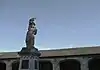 Oude abdij van Neufmoustier: twee vleugels van het oude klooster, gevel, crypte en standbeeld van Pierre l'Ermite | |
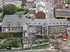
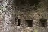
| Fort van Huy (nl) (fr) |
Huy | 50°31′04″N 5°14′16″E / 50.517868°N 5.237675°E |
61031-CLT-0025-01 Info |
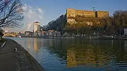 Fort van Huy, chaussées Napoléon | ||
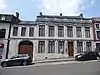
| Old Grain Exchange, today home of Fondation Bolly-Charlier (nl) (fr) |
Huy | place Verte n° 6 | 50°31′05″N 5°14′30″E / 50.518161°N 5.241559°E |
61031-CLT-0026-01 Info |
 Oude graanbeurs, tegenworodig huis van Fondation Bolly-Charlier | |
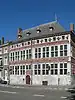
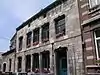
| Town hall (nl) (fr) |
Huy | Huy | 50°31′06″N 5°14′28″E / 50.518330°N 5.241225°E |
61031-CLT-0031-01 Info |
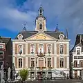 Raadhuis | |
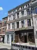
| Hotel: facades, roofs and porch (nl) (fr) |
Huy | rue l'Apleit n°15 | 50°31′11″N 5°14′23″E / 50.519674°N 5.239614°E |
61031-CLT-0032-01 Info |
 Hôtel: gevels, daken en portaal | |
| Town walls (ramparts) (nl) (fr) |
Huy | 50°31′04″N 5°14′40″E / 50.517640°N 5.244495°E |
61031-CLT-0033-01 Info |
 Wallen | ||
| House "Lebrun" (nl) (fr) |
Huy | rue l'Apleit n° 8 | 50°31′11″N 5°14′25″E / 50.519824°N 5.240269°E |
61031-CLT-0034-01 Info |
 Huis "Lebrun": gevels en daken | |
| citadel and the site of Mont Picard (nl) (fr) |
Huy | 50°30′53″N 5°13′29″E / 50.514853°N 5.224830°E |
61031-CLT-0036-01 Info |
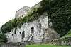 Site van het ensemble van de citadel en de terreinen van Mont Picard | ||
| house (nl) (fr) |
Huy | rue du Pont n°16 | 50°31′08″N 5°14′20″E / 50.519000°N 5.238896°E |
61031-CLT-0037-01 Info |
 Huis: gevels en daken | |
| house (nl) (fr) |
Huy | rue l'Apleit n° 9 | 50°31′10″N 5°14′24″E / 50.519583°N 5.239990°E |
61031-CLT-0038-01 Info |
||
| Park Vierset (nl) (fr) |
Huy | rue Rioul | 50°31′25″N 5°14′35″E / 50.523707°N 5.243014°E |
61031-CLT-0039-01 Info |
||
| Street (nl) (fr) |
Huy | Rue des Frères Mineurs | 50°31′06″N 5°14′28″E / 50.518400°N 5.241068°E |
61031-CLT-0040-01 Info |
 Rue des Frères Mineurs | |
| Cottage, named "Alba Ministries" and Ruelle des Larrons (nl) (fr) |
Huy | la ruelle des Larrons | 50°31′07″N 5°14′48″E / 50.518722°N 5.246565°E |
61031-CLT-0041-01 Info |
||
| house (nl) (fr) |
Huy | rue des Tanneurs n° 23 | 50°30′58″N 5°14′26″E / 50.516179°N 5.240658°E |
61031-CLT-0042-01 Info |
 Huis: gevels en daken | |
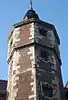
| church Saint-Germain: tower and choir (nl) (fr) |
Huy | 50°30′53″N 5°10′44″E / 50.514658°N 5.178771°E |
61031-CLT-0044-01 Info |
 Kerk Saint-Germain: toren en koor | ||
| stations of the cross with two linden trees (nl) (fr) |
Huy | 50°29′01″N 5°11′29″E / 50.483476°N 5.191410°E |
61031-CLT-0049-01 Info |
 Ensemble van de lindeboom, het kruisbeeld en de directe omgeving | ||
| citadel extension (nl) (fr) |
Huy | Ben-Ahin | 50°30′59″N 5°13′30″E / 50.516457°N 5.224999°E |
61031-CLT-0050-01 Info |
||
| Ile des Béguines & Ile des Chanoines (nl) (fr) |
Huy | 50°30′21″N 5°08′27″E / 50.505855°N 5.140921°E |
61031-CLT-0051-01 Info |
|||
| Church of Sainte-Gertrude (nl) (fr) |
Huy | 50°31′49″N 5°17′19″E / 50.530201°N 5.288722°E |
61031-CLT-0052-01 Info |
 Kerk Sainte-Gertrude | ||
| house (nl) (fr) |
Huy | rue du Centre n° 26 | 50°31′36″N 5°15′26″E / 50.526645°N 5.257130°E |
61031-CLT-0053-01 Info |
||
| Church of Sainte-Margueritte (nl) (fr) |
Huy | 50°31′36″N 5°15′27″E / 50.526645°N 5.257496°E |
61031-CLT-0054-01 Info |
|||
| Cense de Solières farmhouse (nl) (fr) |
Huy | Rue du Crucifix n° 1 | 50°29′12″N 5°10′53″E / 50.486547°N 5.181454°E |
61031-CLT-0056-01 Info |
 Boerderij genaamd Cense de Solières: gevels en daken | |
| house (nl) (fr) |
Huy | rue Sous-le-Château n° 42 | 50°31′03″N 5°14′19″E / 50.517452°N 5.238724°E |
61031-CLT-0057-01 Info |
 Huis: hoofdgevel en voorzijde dak | |
| house (nl) (fr) |
Huy | rue René Dubois n°s 71-73 | 50°31′49″N 5°13′10″E / 50.530343°N 5.219404°E |
61031-CLT-0058-01 Info |
||
| house (nl) (fr) |
Huy | rue des Augustins n° 15 | 50°31′10″N 5°14′27″E / 50.519442°N 5.240890°E |
61031-CLT-0059-01 Info |
||
| house (nl) (fr) |
Huy | rue Griange n° 11 | 50°31′04″N 5°14′30″E / 50.517668°N 5.241603°E |
61031-CLT-0061-01 Info |
 Gebouw: gevel en totaliteit van het dak | |
| house (nl) (fr) |
Huy | Grand'Place n° 7 | 50°31′05″N 5°14′29″E / 50.517963°N 5.241312°E |
61031-CLT-0062-01 Info |
||
| fort Beaufort (nl) (fr) |
Huy | 50°31′01″N 5°11′41″E / 50.517052°N 5.194650°E |
61031-CLT-0063-01 Info |
|||
| house and tower (nl) (fr) |
Huy | rue René Dubois n° 13 | 50°31′43″N 5°13′15″E / 50.528528°N 5.220820°E |
61031-CLT-0064-01 Info |
||
| Solières river valley (nl) (fr) |
Huy | 50°29′39″N 5°10′52″E / 50.494242°N 5.181081°E |
61031-CLT-0065-01 Info |
 Vallei van de stroom van Solières | ||
| well (nl) (fr) |
Huy | rue des Cyclamens | 50°30′46″N 5°13′12″E / 50.512705°N 5.220021°E |
61031-CLT-0066-01 Info |
||
| house (nl) (fr) |
Huy | rue des Rotisseurs n° 24 | 50°31′08″N 5°14′23″E / 50.518835°N 5.239780°E |
61031-CLT-0067-01 Info |
 Gevels en daken van het gebouw | |
| house (nl) (fr) |
Huy | Huy | 50°30′16″N 5°16′25″E / 50.504541°N 5.273495°E |
61031-CLT-0068-01 Info |
||
| Castle Beaufort ruins (nl) (fr) |
Huy | 50°31′04″N 5°11′36″E / 50.517893°N 5.193408°E |
61031-CLT-0069-01 Info |
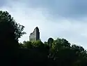 Ruïnes van kasteel van Beaufort | ||
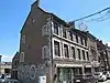
| house (nl) (fr) |
Huy | rue du Marché n° 47 | 50°31′06″N 5°14′39″E / 50.518244°N 5.244212°E |
61031-CLT-0070-01 Info |
 Huis: gevels en daken van het hoofdgebouw en de aanbouw met een toegangspoort, uitsluiting van het geheel van de aanbouw loodrecht op de achterkant | |
| Former abbey Palace of Solière (nl) (fr) |
Huy | 50°28′44″N 5°10′37″E / 50.478945°N 5.176867°E |
61031-CLT-0071-01 Info |
|||
| Chapel Saint Eutrope and spring (nl) (fr) |
Huy | rue du Vieux Moulin | 50°28′45″N 5°10′41″E / 50.479270°N 5.177997°E |
61031-CLT-0072-01 Info |
||
| Castle Bonne Espérance (nl) (fr) |
Huy | rue Bonne espérance n°s 37-37A | 50°31′17″N 5°16′08″E / 50.521282°N 5.268808°E |
61031-CLT-0073-01 Info |
||
| house Loumaye (Château Bodart) (nl) (fr) |
Huy | rue Bonne-Espérance n° 34-35 | 50°31′17″N 5°16′07″E / 50.521415°N 5.268711°E |
61031-CLT-0074-01 Info |
||
| Pastorage house (nl) (fr) |
Huy | rue Saint-Mengold, n° 5 | 50°31′05″N 5°14′32″E / 50.517999°N 5.242142°E |
61031-CLT-0075-01 Info |
||
| Park of Castle Van Zuylen (nl) (fr) |
Huy | 50°31′12″N 5°12′20″E / 50.519994°N 5.205462°E |
61031-CLT-0076-01 Info |
|||
| Chapel Saint-Roch à Ben-Ahin (nl) (fr) |
Huy | Ben-Ahin | 50°30′40″N 5°10′55″E / 50.511062°N 5.181851°E |
61031-CLT-0078-01 Info |
||
| house (nl) (fr) |
Huy | rue du Pont n°s 26-28 | 50°31′09″N 5°14′19″E / 50.519240°N 5.238696°E |
61031-CLT-0079-01 Info |
 Huis: hoofdgevel, puntgevel brugzijde, daken | |
| house (nl) (fr) |
Huy | rue du Marché n° 39 | 50°31′05″N 5°14′38″E / 50.518054°N 5.243864°E |
61031-CLT-0080-01 Info |
 Huis: gevels, daken, puntgevel | |
| house (nl) (fr) |
Huy | place Saint-Denis, n° 4 | 50°31′07″N 5°14′43″E / 50.518643°N 5.245187°E |
61031-CLT-0081-01 Info |
||
| house (nl) (fr) |
Huy | rue du Marais n° 135 | 50°31′44″N 5°15′17″E / 50.528860°N 5.254793°E |
61031-CLT-0082-01 Info |
 Huis: hoofdgevel, puntgevel, daken | |
| house (nl) (fr) |
Huy | rue du Marais n° 137 | 50°31′44″N 5°15′17″E / 50.528820°N 5.254720°E |
61031-CLT-0083-01 Info |
||
| West gable with decorative arches, remains of the leper colony of Grands Malades, and the remains of the eastern gable (ground floor) and the interior with the remains of arches (nl) (fr) |
Huy | quai de Compiègne 54, Huy | 50°31′50″N 5°14′27″E / 50.530493°N 5.240946°E |
61031-CLT-0084-01 Info |
||
| Ruins of the tower Gabelle and adjoining wall (nl) (fr) |
Huy | chaussée des Forges n° 4 | 50°30′45″N 5°14′28″E / 50.512592°N 5.241008°E |
61031-CLT-0085-01 Info |
||
| Farmhouse of former leper colony Grand Malades (nl) (fr) |
Huy | chaussée de Waremme, ongeveer bij n° 142 | 50°31′50″N 5°14′19″E / 50.530545°N 5.238576°E |
61031-CLT-0086-01 Info |
||
| Kakyerie house (nl) (fr) |
Huy | Quai de Compiègne n° 62 | 50°32′10″N 5°15′09″E / 50.536003°N 5.252588°E |
61031-CLT-0087-01 Info |
 Huis, genaamd Kakyerie | |
| parts of the old monastery of the Crosiers (Canons Regular of the Order of the Holy Cross): The 18th century entrance porch, the surrounding wall common to the old pub and porch, and the old brewery (wall and roof) (nl) (fr) |
Huy | rue des Larrons n° 23 | 50°30′58″N 5°14′32″E / 50.516175°N 5.242143°E |
61031-CLT-0091-01 Info |
 Bepaalde delen van het oude klooster van de kruisheren: de ingangsportiek Lodewijk XIV, de omliggende muur gemeenschappelijk voor de oude brasserie en portiek, en de oude brasserie (gevel en dak) | |
| Church Notre-Dame de la Sarte (nl) (fr) |
Huy | 50°30′50″N 5°15′02″E / 50.513872°N 5.250436°E |
61031-CLT-0093-01 Info |
 Kerk Notre-Dame de la Sarte | ||
| house cellar (nl) (fr) |
Huy | rue des Frères Mineurs n° 6 (M) | 50°31′05″N 5°14′34″E / 50.518171°N 5.242698°E |
61031-CLT-0094-01 Info |
||
| "Legrand" house (nl) (fr) |
Huy | rue des Frères Mineurs n°1 | 50°31′05″N 5°14′33″E / 50.518047°N 5.242543°E |
61031-CLT-0096-01 Info |
 Huis genaamd "Legrand" | |
| house (nl) (fr) |
Huy | rue du Pont n°18 | 50°31′09″N 5°14′20″E / 50.519034°N 5.238865°E |
61031-CLT-0097-01 Info |
 Huis: gevels en daken | |
| collegiate church of Notre-Dame, except the organ (nl) (fr) |
Huy | 50°31′08″N 5°14′17″E / 50.518824°N 5.238167°E |
61031-PEX-0001-01 Info |
|||
| Old fountain named Bassinia (nl) (fr) |
Huy | 50°31′05″N 5°14′27″E / 50.518074°N 5.240894°E |
61031-PEX-0002-01 Info |
See also
References
- Belgian heritage register: Direction générale opérationnelle - Aménagement du territoire, Logement, Patrimoine et Energie (DG4)
- www.dglive.be