This table shows an overview of the protected heritage sites in the Walloon town Herstal. This list is part of Belgium's national heritage.
| Object | Year/architect | Town/section | Address | Coordinates | Number? | Image |
|---|---|---|---|---|---|---|
| Chapel of Saint-Lambert (nl) (fr) |
Herstal | 50°39′54″N 5°37′48″E / 50.664872°N 5.630094°E |
62051-CLT-0001-01 Info |
 Kapel Saint-Lambert | ||
| 17th century house, now a museum (nl) (fr) |
Herstal | place Licour 25 | 50°40′15″N 5°38′20″E / 50.670699°N 5.638924°E |
62051-CLT-0002-01 Info |
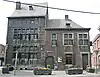 Huis uit 17e eeuw, momenteel museum | |
| Pepin Tower (nl) (fr) |
Herstal | place Licour n° 13 | 50°40′13″N 5°38′20″E / 50.670150°N 5.639001°E |
62051-CLT-0003-01 Info |
 Toren Pépin | |
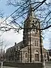
| Church Notre-Dame de la Licour (nl) (fr) |
Herstal | 50°40′13″N 5°38′26″E / 50.670380°N 5.640521°E |
62051-CLT-0004-01 Info |
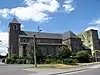 Kerk Notre-Dame de la Licour | ||
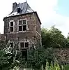
| Breuer house (nl) (fr) |
Herstal | place Coronmeuse, n°26 | 50°39′18″N 5°36′37″E / 50.655044°N 5.610293°E |
62051-CLT-0005-01 Info |
||
| Motte (of motte-and-bailey) (nl) (fr) |
Herstal | 50°41′38″N 5°33′54″E / 50.693840°N 5.564899°E |
62051-CLT-0006-01 Info |
|||
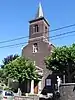
| Church of Saint-Rémy (nl) (fr) |
Herstal | 50°41′36″N 5°33′49″E / 50.693222°N 5.563710°E |
62051-CLT-0008-01 Info |
 Kerk Saint-Rémy: koor, drie traveeën van middenbeuk | ||
| Presbytery: facades, roofs, chimneys and two staircases (nl) (fr) |
Herstal | place Licour n° 52 | 50°40′14″N 5°38′25″E / 50.670671°N 5.640152°E |
62051-CLT-0011-01 Info |
||
| Organs (Arnold Clerinx - 1870) Church of Saint-Lambert (nl) (fr) |
Herstal | 50°39′34″N 5°37′27″E / 50.659377°N 5.624057°E |
62051-CLT-0013-01 Info |
|||
| Ruins of old castle chapel Bouxthay (nl) (fr) |
Herstal | chaussée de Brunehaut | 50°40′11″N 5°36′05″E / 50.669679°N 5.601374°E |
62051-CLT-0014-01 Info |
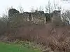 Ruïnes oude kapel van kasteel Bouxthay | |
| Wandre bridge (nl) (fr) |
Herstal | 50°40′23″N 5°38′40″E / 50.673129°N 5.644542°E |
62051-CLT-0015-01 Info |
|||
| Wandre bridge (nl) (fr) |
Herstal | 50°40′23″N 5°38′40″E / 50.673129°N 5.644542°E |
62051-PEX-0001-01 Info |
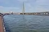 Brug van Wandre |
See also
Wikimedia Commons has media related to Cultural heritage monuments in Herstal.
References
- Belgian heritage register: Direction générale opérationnelle - Aménagement du territoire, Logement, Patrimoine et Energie (DG4)
- www.dglive.be
This article is issued from Wikipedia. The text is licensed under Creative Commons - Attribution - Sharealike. Additional terms may apply for the media files.