This table shows an overview of the protected heritage sites in the Walloon town Hannut. This list is part of Belgium's national heritage.
| Object | Year/architect | Town/section | Address | Coordinates | Number? | Image |
|---|---|---|---|---|---|---|
| Choir and tower of the church of Saint-Christophe (nl) (fr) |
Hannuit | Hannut | 50°40′16″N 5°04′41″E / 50.671001°N 5.078007°E |
64034-CLT-0003-01 Info |
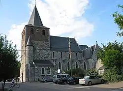 Koor en toren van de kerk Saint-Christophe | |
| Tumulus of Avernas (nl) (fr) |
Hannuit | Hannut | 50°42′05″N 5°04′17″E / 50.701350°N 5.071273°E |
64034-CLT-0004-01 Info |
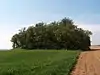 Tumulus van Avernas en het ensemble dat wordt gevormd door deze tumulus met zijn omgeving | |
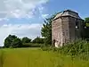
| Castle à Trognée and its surroundings (nl) (fr) |
Hannuit | Trognée | 50°41′19″N 5°07′25″E / 50.688700°N 5.123563°E |
64034-CLT-0005-01 Info |
||
| Chapel of Saint-Donat Blehen and the hill on which the building stands, and the nearby burial mound (nl) (fr) |
Hannuit | 50°40′05″N 5°07′49″E / 50.668194°N 5.130275°E |
64034-CLT-0006-01 Info |
 Kapel Saint-Donat de Blehen en de heuvel waarop het gebouw staat, en de nabijgelegen grafheuvel | ||
| Church Notre-Dame de l'Assomption (nl) (fr) |
Hannuit | 50°41′41″N 5°04′44″E / 50.694753°N 5.078869°E |
64034-CLT-0007-01 Info |
 Kerk Notre-Dame de l'Assomption | ||
| Towers dotted along the wall around the property of Saint-Hubert and the wall with which they are linked (nl) (fr) |
Hannuit | Merdorp | 50°39′03″N 4°59′42″E / 50.650840°N 4.994974°E |
64034-CLT-0008-01 Info |
||
| Moxhe castle and its surrounding area (nl) (fr) |
Hannuit | 50°37′46″N 5°04′44″E / 50.629392°N 5.078900°E |
64034-CLT-0009-01 Info |
|||
| Area bordering Moxhe castle (nl) (fr) |
Hannuit | 50°37′40″N 5°04′43″E / 50.627852°N 5.078473°E |
64034-CLT-0010-01 Info |
|||
| Tower of the church Saint-Martin (nl) (fr) |
Hannuit | Thisnes | 50°39′55″N 5°02′53″E / 50.665322°N 5.048099°E |
64034-CLT-0011-01 Info |
 Toren van de kerk Saint-Martin | |
| Church of Thisnes and (some of) its surroundings (nl) (fr) |
Hannuit | 50°39′56″N 5°02′49″E / 50.665694°N 5.047061°E |
64034-CLT-0012-01 Info |
|||
| Tumulus "Tombe de l'Empereur" (nl) (fr) |
Hannuit | 50°38′17″N 5°05′07″E / 50.638174°N 5.085267°E |
64034-CLT-0013-01 Info |
.JPG.webp) Tombe de l'Empereur en het ensemble wat wordt gevormd door de tumulus en een deel van het perceel waarop de tumulus gelegen is | ||
| Two wooded lanes and surroundings (nl) (fr) |
Hannuit | Hannut | 50°42′05″N 5°07′04″E / 50.701266°N 5.117782°E |
64034-CLT-0014-01 Info |
||
| Ramparts of Saint-Christophe (nl) (fr) |
Hannuit | rue de l'Aite | 50°40′14″N 5°04′33″E / 50.670521°N 5.075755°E |
64034-CLT-0015-01 Info |
 Petit Bosquet aan de rue de l'Aite en de wallen van Saint-Christophe | |
| Chapel Notre Dame de Bon Secours (nl) (fr) |
Hannuit | Hannut | 50°39′11″N 5°05′39″E / 50.653180°N 5.094225°E |
64034-CLT-0016-01 Info |
||
| Lens-Saint-Rémy priory, the square, the wooded lane, the church and the rectory (nl) (fr) |
Hannuit | Lens-Saint-Rémy | 50°39′21″N 5°07′49″E / 50.655864°N 5.130317°E |
64034-CLT-0017-01 Info |
||
| Organs of the church of Lens-Saint-Rémy (nl) (fr) |
Hannuit | 50°39′17″N 5°08′00″E / 50.654682°N 5.133412°E |
64034-CLT-0019-01 Info |
|||
| The boulder "Pierre Motet", situated at the foot of the "Tiège de Velupon" (nl) (fr) |
Hannuit | Lens-Saint-Remy | 50°39′03″N 5°07′54″E / 50.650809°N 5.131738°E |
64034-CLT-0020-01 Info |
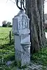 De "Pierre Motet", gelegen aan de voet van de "Tiège de Velupon" | |
| Tumulus: 2 tumuli in the "Bois des Tombes" (nl) (fr) |
Hannuit | Hannut | 50°38′18″N 4°59′48″E / 50.638297°N 4.996685°E |
64034-CLT-0021-01 Info |
.JPG.webp) Tumuli van het Bois des Tombes, het ensemble van twee tumuli en omgeving | |
| church Notre-Dame de l'Assomption and surroundings (nl) (fr) |
Hannuit | Avernas-le -Baudouin | 50°41′41″N 5°04′43″E / 50.694730°N 5.078526°E |
64034-CLT-0023-01 Info |
||
| Wells (nl) (fr) |
Hannuit | Rue du Curé 2, Moxhe | 50°37′49″N 5°04′55″E / 50.630189°N 5.081861°E |
64034-CLT-0024-01 Info |
||
| Tumulus archeological site, called locally "A la tombe" (nl) (fr) |
Hannuit | 50°42′05″N 5°04′17″E / 50.701350°N 5.071273°E |
64034-PEX-0001-01 Info |
Tumulus van Avernas, de archeologische site, ter plaatse genaamd "A la tombe" | ||
| Tumulus archeological site, called locally "La tombe de Blehen" (nl) (fr) |
Hannuit | 50°40′08″N 5°07′46″E / 50.668948°N 5.129521°E |
64034-PEX-0002-01 Info |
.JPG.webp) Tumulus van Blehen, de archeologische site, ter plaatse genaamd "La tombe de Blehen" | ||
| Tumulus archeological site, called locally "Tombe de l'Empereur" (nl) (fr) |
Hannuit | 50°38′17″N 5°05′07″E / 50.638174°N 5.085267°E |
64034-PEX-0003-01 Info |
Tombe de l'Empereur, de archeologische site | ||
| Tumulus archeological site, called locally "Bois des Tombes" (nl) (fr) |
Hannuit | 50°38′18″N 4°59′48″E / 50.638297°N 4.996685°E |
64034-PEX-0004-01 Info |
Tumuli van het Bois des Tombes (Hannuit), de archeologische site van 2 tumuli |
See also
Wikimedia Commons has media related to Cultural heritage monuments in Hannut.
References
- Belgian heritage register: Direction générale opérationnelle - Aménagement du territoire, Logement, Patrimoine et Energie (DG4)
- www.dglive.be
This article is issued from Wikipedia. The text is licensed under Creative Commons - Attribution - Sharealike. Additional terms may apply for the media files.