This table shows an overview of the protected heritage sites in the Walloon town Erquelinnes. This list is part of Belgium's national heritage.
| Object | Year/architect | Town/section | Address | Coordinates | Number? | Image |
|---|---|---|---|---|---|---|
| The towers, the main house and the stables of the castle farm Montignies-Saint-Christophe (nl) (fr) |
Erquelinnes | 50°17′01″N 4°11′10″E / 50.283634°N 4.186177°E |
56022-CLT-0001-01 Info |
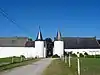 De torens, het hoofdgebouw en de stallen van het kasteelboerderij van Montignies-Saint-Christophe | ||
| The bridge called "Pont Romain" in Montignies-Saint-Christophe (nl) (fr) |
Erquelinnes | 50°16′58″N 4°10′58″E / 50.282695°N 4.182742°E |
56022-CLT-0002-01 Info |
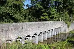 De brug genaamd "Pont Romain" te Montignies-Saint-Christophe | ||
| The Roman bridge and the surrounding land in Montignies-Saint-Christophe (nl) (fr) |
Erquelinnes | 50°16′57″N 4°10′52″E / 50.282441°N 4.181153°E |
56022-CLT-0003-01 Info |
.JPG.webp) De Romeinse brug en het omliggende land in Montignies-Saint-Christophe | ||
| The church of Saint-Medard (nl) (fr) |
Erquelinnes | 50°18′34″N 4°09′05″E / 50.309423°N 4.151514°E |
56022-CLT-0004-01 Info |
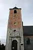 De kerk van Saint-Médard | ||
| The castle of Solre-sur-Sambre (nl) (fr) |
Erquelinnes | 50°18′35″N 4°09′21″E / 50.309753°N 4.155708°E |
56022-CLT-0005-01 Info |
 Het kasteel van Solre-sur-Sambre | ||
| The tower of the farm "Ferme du Clocher" in Solre-sur-Sambre (nl) (fr) |
Erquelinnes | 50°18′21″N 4°08′49″E / 50.305739°N 4.146986°E |
56022-CLT-0006-01 Info |
 De toren van het boerderij "Ferme du Clocher" te Solre-sur-Sambre | ||
| The chapel of Saint-Antoine-sur-Sambre in Solre (nl) (fr) |
Erquelinnes | 50°18′28″N 4°09′14″E / 50.307691°N 4.154026°E |
56022-CLT-0007-01 Info |
|||
| The facades and roofs of buildings of the farm "La Tour" on the rue Notre-Dame 18 (nl) (fr) |
Erquelinnes | rue Notre-Dame, 18 | 50°18′38″N 4°07′29″E / 50.310446°N 4.124711°E |
56022-CLT-0008-01 Info |
See also
Wikimedia Commons has media related to Cultural heritage monuments in Erquelinnes.
References
- Belgian heritage register: Direction générale opérationnelle - Aménagement du territoire, Logement, Patrimoine et Energie (DG4)
- www.dglive.be
This article is issued from Wikipedia. The text is licensed under Creative Commons - Attribution - Sharealike. Additional terms may apply for the media files.