This table shows an overview of the protected heritage sites in the Walloon town Donceel. This list is part of Belgium's national heritage.
| Object | Year/architect | Town/section | Address | Coordinates | Number? | Image |
|---|---|---|---|---|---|---|
| Roman tower of church Saints-Cyr-et-Julitte (nl) (fr) |
Donceel | 50°38′52″N 5°19′17″E / 50.647763°N 5.321302°E |
64023-CLT-0001-01 Info |
|||
| windmill (nl) (fr) |
Donceel | rue du Moulin, à côté du n°65 | 50°39′14″N 5°19′36″E / 50.653898°N 5.326800°E |
64023-CLT-0002-01 Info |
||
| Degive farmhouse (nl) (fr) |
Donceel | rue Ribatte, n°236 | 50°38′14″N 5°19′01″E / 50.637092°N 5.317048°E |
64023-CLT-0003-01 Info |
 Boerderij Degive | |
| Chapel 'Du Temple' (nl) (fr) |
Donceel | rue des Templiers | 50°38′23″N 5°19′05″E / 50.639770°N 5.318043°E |
64023-CLT-0004-01 Info |
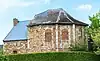 Kapel ('Chapelle du Temple') | |
| church of St. Pierre (nl) (fr) |
Donceel | 50°38′21″N 5°19′06″E / 50.639063°N 5.318198°E |
64023-CLT-0005-01 Info |
|||
| Organs of church St. Pierre (nl) (fr) |
Donceel | 50°38′21″N 5°19′05″E / 50.639049°N 5.318057°E |
64023-CLT-0006-01 Info |
|||
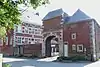
| Castle (keep) (nl) (fr) |
Donceel | rue de l'Eglise, n°28 | 50°39′37″N 5°18′38″E / 50.660266°N 5.310450°E |
64023-CLT-0008-01 Info |
See also
Wikimedia Commons has media related to Cultural heritage monuments in Donceel.
References
- Belgian heritage register: Direction générale opérationnelle - Aménagement du territoire, Logement, Patrimoine et Energie (DG4)
- www.dglive.be
This article is issued from Wikipedia. The text is licensed under Creative Commons - Attribution - Sharealike. Additional terms may apply for the media files.