This table shows an overview of the protected heritage sites in the Walloon town Bütgenbach. This list is part of Belgium's national heritage.
| Object | Year/architect | Town/section | Address | Coordinates | Number | Image |
|---|---|---|---|---|---|---|
| Farmhouse (nl) (de) |
Bütgenbach | 50°25′39″N 6°12′04″E / 50.427592°N 6.201146°E | 31002 Info | .jpg.webp) Farmhouse | ||
| Schwalmbachtal (area) (nl) (de) |
Bütgenbach | 50°29′57″N 6°17′06″E / 50.499080°N 6.284869°E | 31041 Info | .jpg.webp) Schwalmbachtal (area) | ||
| Hohe mark (area) (nl) (de) |
Bütgenbach | 50°29′17″N 6°13′45″E / 50.488129°N 6.229235°E | 31044 Info | 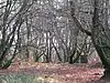 Hohe mark (area) | ||
| Mausheck-Kolberg (area) (nl) (de) |
Bütgenbach | 50°26′13″N 6°11′50″E / 50.436917°N 6.197253°E | 31042 Info | .jpg.webp) Mausheck-Kolberg (area) | ||
| Old basswood or Linden tree (nl) (de) |
Bütgenbach | 50°26′07″N 6°09′52″E / 50.435148°N 6.164545°E | 31043 Info | 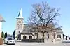 Old basswood or Linden tree | ||
| Farmhouse (nl) (de) |
Bütgenbach | Hof Lindenstrasse 12 | 50°25′59″N 6°09′52″E / 50.433182°N 6.164458°E | 31032 Info | .jpg.webp) Farmhouse | |
| Border marker Julich (nl) (de) |
Bütgenbach | 50°28′42″N 6°18′31″E / 50.478394°N 6.308585°E | 31031 Info |
See also
- Lists of protected heritage sites in the German-speaking Community of Belgium
- List of protected heritage sites in Liège (province)
- Bütgenbach
Wikimedia Commons has media related to Cultural heritage monuments in Bütgenbach.
References
- Belgian heritage register: Direction générale opérationnelle - Aménagement du territoire, Logement, Patrimoine et Energie (DG4)
- www.dglive.be
- Geschützte Objekte in Bütgenbach
This article is issued from Wikipedia. The text is licensed under Creative Commons - Attribution - Sharealike. Additional terms may apply for the media files.