This is a list of the heritage sites in the Western Cape Province, South Africa, as recognized by the South African Heritage Resource Agency.[1]
For additional provincial heritage sites declared by Heritage Western Cape, the provincial heritage resources authority of the Western Cape Province of South Africa, please see the entries at the end of the list. These sites have been declared subsequent to the implementation of the new legislation on 1 April 2000 and unlike those in the SAHRA portion of the list are not former national monuments declared by the former National Monuments Council, the predecessor of both SAHRA and Heritage Western Cape.[2] In the instance of these sites the "identifier" code used is that of Heritage Western Cape rather than SAHRA.
For performance reasons, the following districts have been split off:
- List of heritage sites in Beaufort West
- List of heritage sites in Bellville
- List of heritage sites in Caledon
- List of heritage sites in Cape Town CBD, the Waterfront, and the Bo-Kaap
- List of heritage sites near Cape Town
- List of heritage sites in Clanwilliam
- List of heritage sites in George and Mossel Bay
- List of heritage sites in Knysna
- List of heritage sites in Paarl
- List of heritage sites in Simonstown
- List of heritage sites in Robertson and Montagu
- List of heritage sites in Stellenbosch, Somerset West, and Strand
- List of heritage sites in Swellendam and Riversdale
- List of heritage sites in Table Mountain
- List of heritage sites in Tulbagh
- List of heritage sites in Worcester
- List of heritage sites in Wynberg
| SAHRA identifier | Site name | Description | Town | District | NHRA status | Coordinates | Image |
|---|---|---|---|---|---|---|---|
| 9/2/013/0001 | Fishermen's Cottages, Hotagterklip, Struis Bay, Bredasdorp District | Some 32 kilometres from Bredasdorp, at Hotagterklip near Struis Bay, the new macadamized road cuts through one of these villages. A few houses were destroyed in making the road, but there are attractive groups of dwellings on either side of it. The three houses on the grassy slope on the right-hand side are about sixty years old and have recently been well restored by the Divisional Council of Bredasdorp. They have been raised to the status of proclaimed historical monuments. | Struisbaai | Bredasdorp | Provincial Heritage Site | 34°47′42″S 20°02′36″E / 34.794951°S 20.043226°E |  Some 32 kilometres from Bredasdorp, at Hotagterklip near Struis Bay, the new macadamized road cuts through one of these villages. A few houses were destroyed in making the road, but there are attractive groups of dwellings on either side of it. The three houses on the grassy slope on the right-hand side are about sixty years old and have recently been well restored by the Divisional Council of Bredasdorp. They have been raised to the status of proclaimed historical monuments. |
| 9/2/013/0001/001 | 3 Fishermen's Cottages, Hotagterklip, Struis Bay | This property consists of nine fishermen's cottages which are worthy of preservation in view of various architectural and historical consideration.
|
Struis Bay | Bredasdorp | Provincial Heritage Site | 34°47′37″S 20°02′27″E / 34.793630°S 20.040862°E | 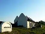 This property consists of nine fishermen's cottages which are worthy of preservation in view of various architectural and historical consideration.
Type of site: House Previous use: Residential. Current use: House. |
| 9/2/013/0001/002 | 4 Fishermen's Cottages, Hotagterklip, Struis Bay | Until quite recently the fishermen's villages, most of them hardly more than hamlets, constituted some of the most interesting and picturesque features to be seen along the coast from Saldanha Bay to far beyond Cape L'Agulhas.
|
Struis Bay | Bredasdorp | Provincial Heritage Site | 34°47′37″S 20°02′28″E / 34.793570°S 20.041117°E | 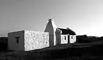 Until quite recently the fishermen's villages, most of them hardly more than hamlets, constituted some of the most interesting and picturesque features to be seen along the coast from Saldanha Bay to far beyond Cape L'Agulhas.
Type of site: House Previous use: Residential. Current use: House. This impressive architectural complex consists of nine fishermen's cottages, which are all typical examples of the traditional vernacular style. |
| 9/2/013/0001/3 | 5 Fishermen's Cottages, Hotagterklip, Struis Bay, Bredasdorp District | Struisbaai | Bredasdorp |  Upload Photo | |||
| 9/2/013/0002 | Waenhuiskrans (Kassiesbaai) Fishing Village, Arniston | Until quite recently the fishermen's villages, most of them hardly more than hamlets, constituted some of the most interesting and picturesque features to be seen along the coast from Saldanha Bay to far beyond Cape L'Agulhas.
|
Arniston | Bredasdorp | Provincial Heritage Site | 34°39′48″S 20°13′53″E / 34.663213°S 20.231508°E | 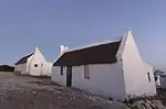 Until quite recently the fishermen's villages, most of them hardly more than hamlets, constituted some of the most interesting and picturesque features to be seen along the coast from Saldanha Bay to far beyond Cape L'Agulhas.
Type of site: House Previous use: residential. Current use: House. |
| 9/2/013/0003 | BREDASDORP MUNICIPAL AREA, GENERAL | Bredasdorp | Bredasdorp | Upload Photo | |||
| 9/2/013/0004 | Bredasdorp Museum, Independent Street, Bredasdorp | This is the Bredasdorp Museum Complex which is already proclaimed a national monument.
The Rectory and the former Anglican Church, now a hall, date from the earliest years of the town.
The Rectory is a very fine Old Cape thatched house.
Now the complex forms the Bredasdorp Museum.
The former house of the Rector of the Anglican Church in Bredasdorp.
|
Bredasdorp | Bredasdorp | Provincial Heritage Site | 34°31′58″S 20°02′18″E / 34.532644°S 20.038314°E |  This is the Bredasdorp Museum Complex which is already proclaimed a national monument.
The Rectory and the former Anglican Church, now a hall, date from the earliest years of the town.
The Rectory is a very fine Old Cape thatched house.
Now the complex forms the Bredasdorp Museum.
The former house of the Rector of the Anglican Church in Bredasdorp.
Type of site: House Previous use: Residence : Parsonage. Current use: Museum. |
| 9/2/013/0005 | Mountain View, Kreupelhout Drive, Bredasdorp | Rectangular building in the vernacular style, hipped, thatched roof, eyebrow gable over front door.
Outbuildings to rear This oblong house, with its predominantly Cape Dutch features, dates from approximately 1840.
|
Bredasdorp | Bredasdorp | Provincial Heritage Site | 34°32′30″S 20°02′26″E / 34.541676°S 20.040610°E | 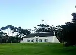 Rectangular building in the vernacular style, hipped, thatched roof, eyebrow gable over front door.
Outbuildings to rear This oblong house, with its predominantly Cape Dutch features, dates from approximately 1840.
Type of site: House Previous use: Residential. Current use: House. |
| 9/2/013/0006 | Proposed memorial for the East Indiaman "Arniston" | Arniston | Bredasdorp | ||||
| 9/2/013/0007 | Dutch Reformed Church, Main Street, Napier | This cruciform church was erected in 1926.
Despite a variety of architectural styles – as evidenced by the high gable walls in particular – the building forms a harmonious unit.
|
Napier | Bredasdorp | Provincial Heritage Site | 34°28′24″S 19°53′58″E / 34.473203°S 19.899561°E | 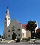 This cruciform church was erected in 1926.
Despite a variety of architectural styles – as evidenced by the high gable walls in particular – the building forms a harmonious unit.
Type of site: Church Previous use: Church. Current use: Church : Dutch Reformed. |
| 9/2/013/0008 | Cape L'Agulhas Lighthouse, Bredasdorp District | The tower is circular with the former living- quarters on both sides, and of a height of 65 feet.
This lighthouse was completed in 1849 at a cost of approximately R24 000 and is the second oldest existing structure of its kind in South Africa.
Since then it has contributed largely towards reducing the number of shipwrecks on the most dangerous part of the South African coastline.
|
Bredasdorp | Provincial Heritage Site | 34°49′42″S 20°00′33″E / 34.8283333333°S 20.0091666666°E | 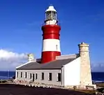 The tower is circular with the former living- quarters on both sides, and of a height of 65 feet.
This lighthouse was completed in 1849 at a cost of approximately R24 000 and is the second oldest existing structure of its kind in South Africa.
Since then it has contributed largely towards reducing the number of shipwrecks on the most dangerous part of the South African coastline.
Type of site: Lighthouse Current use: Lighthouse. | |
| 9/2/013/0009 | 25 Church Street, Bredasdorp | Bredasdorp | Bredasdorp | 34°32′03″S 20°02′25″E / 34.534033°S 20.040379°E | Upload Photo | ||
| 9/2/013/0010 | Alfred Dowling Building, Bredasdorp | Bredasdorp | Bredasdorp | Upload Photo | |||
| 9/2/013/0011 | Dollas Downs 264, Bredasdorp District | Bredasdorp | Provisional Protection | 34°32′00″S 20°02′30″E / 34.533445°S 20.041680°E | Upload Photo | ||
| 9/2/013/0012 | St. Saviours Anglican Church, Napier, Bredasdorp District | Bredasdorp | Bredasdorp | Demolished | Upload Photo | ||
| 9/2/013/0013 | NAPIER MUNICIPAL AREA, GENERAL | Napier | Bredasdorp | Upload Photo | |||
| 9/2/013/0014 | ELIM VILLAGE, BREDASDORP DISTRICT, GENERAL | Elim | Bredasdorp | Upload Photo | |||
| 9/2/013/0015 | Burial site of Birkenhead casualties, Danger Point, Bredasdorp | Danger Point | Bredasdorp | Upload Photo | |||
| 9/2/013/0016 | Ratel Rivier, Buffel Jagd, Bredasdorp District | Bredasdorp | Bredasdorp | Upload Photo | |||
| 9/2/013/0017 | Springfield 287, Bredasdorp District | Originally Soutspansberg, together with Rhenosterkop, first title deed 1747.
Came under separate title in 1869.
Owned by Lord de Saumarez after WW2.
|
Bredasdorp | Provincial Heritage Site | 34°32′05″S 20°02′39″E / 34.534623°S 20.044041°E | Upload Photo | |
| 9/2/013/0018 | Fisherman's Cottage, Pratt Street, Arniston | Type of site: House
|
Arniston | Bredasdorp | Provincial Heritage Site | 34°40′09″S 20°13′55″E / 34.669297°S 20.231860°E | 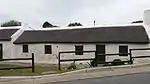 Type of site: House
Current use: Residential. A particularly fine example of the folk architecture of South Africa. |
| 9/2/013/0019 | 14 and 16 Lourens Street, Bredasdorp | Two restored and already proclaimed 3-bay thatched cottages.
These two houses in the typical vernacular style date from approximately the middle of the nineteenth century.
Together they form an interesting unit and an important architectural element of Bredasdorp.
|
Bredasdorp | Bredasdorp | Provincial Heritage Site | 34°32′02″S 20°02′05″E / 34.533764°S 20.034836°E | 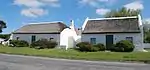 Two restored and already proclaimed 3-bay thatched cottages.
These two houses in the typical vernacular style date from approximately the middle of the nineteenth century.
Together they form an interesting unit and an important architectural element of Bredasdorp.
Type of site: House Current use: House. |
| 9/2/013/0020 | De Hoop Nature Reserve, Bredasdorp District | Bredasdorp | Bredasdorp | 34°25′20″S 20°32′43″E / 34.422266°S 20.545407°E |  | ||
| 9/2/013/0020/001 | De Hoop homestead, De Hoop Nature Reserve, Bredasdorp District | This farmstead consists of five historic buildings which dates from approximately the late eighteenth century.
The group of buildings with its large "werf" and surrounding ring-wall, forms a unique historical and architectural complex. |
Bredasdorp | Provincial Heritage Site | 34°27′18″S 20°23′54″E / 34.454935°S 20.398428°E | This farmstead consists of five historic buildings which dates from approximately the late eighteenth century.
The group of buildings with its large "werf" and surrounding ring-wall, forms a unique historical and architectural complex. | |
| 9/2/013/0020/2 | Melkkamer, De Hoop Nature Reserve, Bredasdorp District | Bredasdorp | Bredasdorp | Pending | Upload Photo | ||
| 9/2/013/0021 | Old Anglican Church, Main Road, Struisbaai | Type of site: Church
|
Struisbaai | Bredasdorp | Provincial Heritage Site | 34°48′03″S 20°03′07″E / 34.800870°S 20.051826°E | _(2).jpg.webp) Type of site: Church
Previous use: Church. Current use: Church : Dutch Reformed. |
| 9/2/013/0023 | Cottages, Rhenosterkop, Bredasdorp District | This property, which is situated on the coast in the so-called Duineveld and on which large numbers of milk-wood trees are found, is of considerable importance both as a natural resource and from the point of view of ecology.
|
Bredasdorp | Provincial Heritage Site | 34°45′45″S 19°55′52″E / 34.762363°S 19.931195°E | Upload Photo | |
| 9/2/013/0024 | White milkwood tree, Rhenosterfontein, Bredasdorp District | Type of site: Tree. This milkwood tree on the farm Rhenosterfontein was in 1991 described by the Dendrological Association of SA as the largest identified example of its kind. It is possible that the tree could be between 600 and 1000 years old. | Bredasdorp | Provincial Heritage Site | 34°29′48″S 20°07′37″E / 34.496796°S 20.126822°E | Upload Photo | |
| 9/2/013/0025 | Old Police Station & gaol, 16 Hope Street, Bredasdorp | Bredasdorp | Bredasdorp | Upload Photo | |||
| 9/2/013/0026 | STRUISBAAI LOCAL AREA, BREDASDORP DISTRICT, GENERAL | Struisbaai | Bredasdorp | Upload Photo | |||
| 9/2/013/0027 | L'AGULHAS LOCAL AREA, BREDASDORP DISTRICT, GENERAL | L'Agulhas | Bredasdorp | Upload Photo | |||
| 9/2/013/0028 | Southernmost tip of Africa, L'Agulhas, Bredasdorp District | L'Agulhas | Bredasdorp | 34°49′51″S 20°00′44″E / 34.830886°S 20.012173°E | Upload Photo | ||
| 9/2/013/0029 | BREDASDORP MAGISTERIAL DISTRICT, GENERAL | Bredasdorp | Bredasdorp | Upload Photo | |||
| 9/2/013/0030 | Agulhas National Park, Bredasdorp District | Bredasdorp | Bredasdorp | 34°44′28″S 19°51′57″E / 34.741023°S 19.865715°E | .jpg.webp) | ||
| 9/2/013/0031 | Baardskeerdersbos, Bredasdorp District | Bredasdorp | Bredasdorp | Upload Photo | |||
| 9/2/013/0032 | ARNISTON LOCAL AREA, GENERAL | Arniston | Bredasdorp | Upload Photo | |||
| 9/2/013/0033 | Struis Point Beacon, Arniston | Arniston | Bredasdorp | Upload Photo | |||
| 9/2/013/0034 | 17 Matthee Street, Bredasdorp | Bredasdorp | Bredasdorp | 34°32′10″S 20°02′18″E / 34.536034°S 20.038329°E | Upload Photo | ||
| 9/2/016/0001 | Dutch Reformed Church, Andries Pretorius Street, Calitzdorp | Type of site: Church
|
Calitzdorp | Calitzdorp | Provincial Heritage Site | 33°31′44″S 21°41′18″E / 33.528820°S 21.688390°E | 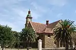 Type of site: Church
Current use: Church : Dutch Reformed. |
| 9/2/016/0002 | 1 Queen Street, Calitzdorp | Calitzdorp | Calitzdorp | Pending Declaration | 33°32′08″S 21°41′07″E / 33.535653°S 21.685173°E | Upload Photo | |
| 9/2/016/0003 | Warmwater, Calitzdorp | Calitzdorp | Calitzdorp | 33°39′42″S 21°46′28″E / 33.661550°S 21.774381°E | Upload Photo | ||
| 9/2/016/0004 | Hermies, 21 Voortrekker Street, Calitzdorp | Calitzdorp | Calitzdorp | 33°31′53″S 21°41′46″E / 33.531448°S 21.696033°E | Upload Photo | ||
| 9/2/016/0005 | Mossienes, Calitzdorp | Calitzdorp | Calitzdorp | Upload Photo | |||
| 9/2/016/0006 | CALITZDORP MUNICIPAL AREA, GENERAL | Calitzdorp | Calitzdorp | Upload Photo | |||
| 9/2/016/0007 | CALITZDORP MAGISTERIAL AREA, GENERAL | Calitzdorp | Calitzdorp | Upload Photo | |||
| 9/2/021/0001 | Old Tollhouse, Michell's Pass, Ceres | The Old Tollhouse was built shortly after the completion of Michell's Pass in 1848.
From 1 January 1849 toll charges were collected here on animals and vehicles.
Since the Michell's Pass opened an easy route to the north and because, when diamonds were subsequently discovered, it was on the main route from the Cape, the tollhouse played an
exceptionally important role.
|
Ceres | Ceres | Provincial Heritage Site | 33°23′27″S 19°17′10″E / 33.390835°S 19.285995°E |  The Old Tollhouse was built shortly after the completion of Michell's Pass in 1848.
From 1 January 1849 toll charges were collected here on animals and vehicles.
Since the Michell's Pass opened an easy route to the north and because, when diamonds were subsequently discovered, it was on the main route from the Cape, the tollhouse played an
exceptionally important role.
Type of site: Toll |
| 9/2/021/0002 | Zandrug Farm, Kagga Kamma Nature Reserve, Ceres District | Ceres | Ceres | Upload Photo | |||
| 9/2/021/0003 | Michell's Pass, Ceres District | Ceres | Ceres | Pending Declaration | 33°22′44″S 19°17′47″E / 33.378796°S 19.296414°E | Upload Photo | |
| 9/2/021/0004 | Cemetery, Owen Street, Ceres | Ceres | Ceres | 33°22′32″S 19°18′30″E / 33.375472°S 19.308412°E | Upload Photo | ||
| 9/2/021/0005 | Karoopoort Outspan, Ceres District | Werf wall enclosing two buildings.
The first a langhuis with thatched roof and oven attached to the back.
The second a large rectangular outhouse with tin roof and dormered loft entrance with ladder.
|
Ceres | Provincial Heritage Site | 33°13′06″S 19°42′12″E / 33.218205°S 19.703314°E |  Werf wall enclosing two buildings.
The first a langhuis with thatched roof and oven attached to the back.
The second a large rectangular outhouse with tin roof and dormered loft entrance with ladder.
Type of site: House Current use: Vacant. Karoopoort was a well-known and popular outspan for early travellers to the North. It was described, among others, by the travellers Lichtenstein and Burchell at the beginning of the nineteenth century. There are also three historic buildings on the site | |
| 9/2/021/0006 | Rocklands, Ceres District | Ceres | Ceres | Upload Photo | |||
| 9/2/021/0007 | Nature Reserve, Ceres | Ceres | Ceres | Upload Photo | |||
| 9/2/021/0008 | CERES MUNICIPAL AREA, GENERAL | Ceres | Ceres | Upload Photo | |||
| 9/2/021/0009 | Boplaas, Ceres District | Collection of buildings: H-shaped house with good internal woodwork and partially glazed screen, soap making house, watermill, and outbuilding with stairs to loft door under thatch roof.
Exterior of main house somewhat changed.
This farm has since 1743 been in the possession of the Van der Merwe family and is well-known in the Afrikaans literature through the works of I.
W.
van der Merwe (Boerneef).
The historic buildings date mostly from the beginning of the 19th century.
|
Ceres | Provincial Heritage Site | 32°58′45″S 19°21′55″E / 32.979166°S 19.365277°E | Upload Photo | |
| 9/2/021/0010 | Verlorenvlei, Ceres District | H-Shaped house, with gables at back and front. Ugly lean-to added along the back. Interesting Dutch detailing on windows, unusual dormer casement in tin roof.
Out buildings appear old and in bad repair.
This farm previously formed part of the original farm Verloren Valley, which was granted to Schalk Willem Pienaar in 1833.
The H-shaped dwelling that dates from 1827 was presumably erected by him.
The outbuildings, which date from the early nineteenth century, are also of interest.
|
Ceres | Provincial Heritage Site | 33°17′00″S 19°42′30″E / 33.283333°S 19.708333°E | 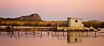 H-Shaped house, with gables at back and front. Ugly lean-to added along the back. Interesting Dutch detailing on windows, unusual dormer casement in tin roof.
Out buildings appear old and in bad repair.
This farm previously formed part of the original farm Verloren Valley, which was granted to Schalk Willem Pienaar in 1833.
The H-shaped dwelling that dates from 1827 was presumably erected by him.
The outbuildings, which date from the early nineteenth century, are also of interest.
Type of site: House Current use: Homestead. Take the R46 from Ceres in a north easterly direction. Continue on the R46 when it turns south before Karoopoort. The turn-off to the farm is approx 10 km along this road. | |
| 9/2/021/0011 | Nooitgedacht, Ceres District | Thatched 5 bayed house with wolfneus gable containing window opening. Impressive loft staircase.
Victorian, central double door with fanlight.
2 pairs of French windows with fanlights.
Stoep with round steps leading up.
Traces of corrugated iron verandah.
|
Ceres | Provincial Heritage Site | 33°08′30″S 19°22′30″E / 33.141667°S 19.375000°E | Upload Photo | |
| 9/2/021/0012 | Excelsior, Ceres District | Late Victorian farm house, with thatched outbuilding.
|
Ceres | Provincial Heritage Site | 32°57′45″S 19°25′55″E / 32.962500°S 19.431944°E | Upload Photo | |
| 9/2/021/0013 | Jan Mostert's Road and Toll House, Michell's Pass, Ceres District | Type of site: Toll | Ceres | Register | 33°22′00″S 19°19′01″E / 33.366655°S 19.316883°E | 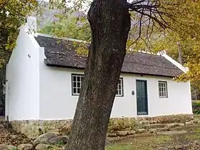 Type of site: Toll | |
| 9/2/021/0014 | CERES MAGISTERIAL DISTRICT, GENERAL. | Ceres | Ceres | Upload Photo | |||
| 9/2/021/0015 | Uintjieskraal, Ceres District | Ceres | Ceres | Pending | Upload Photo | ||
| 9/2/021/0016 | Gydo Pass, Ceres District | Ceres | Ceres | 33°14′05″S 19°19′48″E / 33.234741°S 19.329925°E | Upload Photo | ||
| 9/2/021/0017 | PRINCE ALFRED HAMLET | Prince Alfred Hamlet | 33°17′07″S 19°19′30″E / 33.285344°S 19.324902°E | Upload Photo | |||
| 9/2/031/0001 | Houses in The Mead, Pinelands, Goodwood District | Pinelands | Goodwood |  | |||
| 9/2/031/0001/001 | 17 The Mead, Pinelands, Cape Town | Type of site: House. This is part of the oldest so-called garden city in South Africa. | Cape Town, Pinelands | Goodwood | Provincial Heritage Site | 33°56′28″S 18°29′50″E / 33.941010°S 18.497134°E | Upload Photo |
| 9/2/031/0001/002 | 16 Meadway, Pinelands, Cape Town | Type of site: House Historical and architectural interest
The Pinelands Garden City originated with Richard Stuttaford, who actively promoted this new concept. The town planner and architect Albert J. Thompson drew up the plans in 1919. In 1923 the original section known as the Meadway was laid out and built on State land that previously formed part of the Uitvlugt Forest Reserve. |
Cape Town, Pinelands | Goodwood | Provincial Heritage Site | 33°56′27″S 18°29′52″E / 33.940730°S 18.497734°E |  Type of site: House Historical and architectural interest
The Pinelands Garden City originated with Richard Stuttaford, who actively promoted this new concept.
The town planner and architect Albert J. Thompson drew up the plans in 1919.
In 1923 the original section known as the Meadway was laid out and built on State land that previously formed part of the Uitvlugt Forest Reserve. |
| 9/2/031/0001/003 | 3 Meadway, Pinelands, Cape Town | Type of site: House. This is part of the oldest so-called garden city in South Africa. | Cape Town, Pinelands | Goodwood | Provincial Heritage Site | 33°56′30″S 18°29′50″E / 33.941715°S 18.497334°E |  Type of site: House. This is part of the oldest so-called garden city in South Africa. |
| 9/2/031/0001/004 | 12 Meadway Pinelands, Cape Town | Type of site: House. This is part of the oldest so-called garden city in South Africa. | Cape Town, Pinelands | Goodwood | Provincial Heritage Site | 33°56′28″S 18°29′52″E / 33.941130°S 18.497802°E | Upload Photo |
| 9/2/031/0001/005 | 13 The Mead, Pinelands, Cape Town | Type of site: House. This is part of the oldest so-called garden city in South Africa. | Cape Town, Pinelands | Goodwood | Provincial Heritage Site | 33°56′28″S 18°29′48″E / 33.941068°S 18.496583°E | Upload Photo |
| 9/2/031/0001/006 | 4 Meadway, Pinelands, Cape Town | Type of site: House. This is part of the oldest so-called garden city in South Africa. | Cape Town, Pinelands | Goodwood | Provincial Heritage Site | 33°56′31″S 18°29′52″E / 33.941950°S 18.497722°E | Upload Photo |
| 9/2/031/0001/007 | 1 Meadway, Pinelands, Cape Town | Type of site: House. Historical and architectural interest
The Pinelands Garden City originated with Richard Stuttaford, who actively promoted this new concept. The town planner and architect Albert J. Thompson drew up the plans in 1919. In 1923 the original section known as the Meadway was laid out and built on State land that previously formed part of the Uitvlugt Forest Reserve. |
Cape Town, Pinelands | Goodwood | Provincial Heritage Site | 33°56′27″S 18°29′51″E / 33.940728°S 18.497421°E | Upload Photo |
| 9/2/031/0001/008 | 19 Meadway, Pinelands, Cape Town | Type of site: House. This is part of the oldest so-called garden city in South Africa. | Cape Town, Pinelands | Goodwood | Provincial Heritage Site | 33°56′27″S 18°29′49″E / 33.940715°S 18.496993°E | Upload Photo |
| 9/2/031/0001/009 | 7 The Mead, Pinelands, Cape Town | Type of site: House. This is part of the oldest so-called garden city in South Africa. | Cape Town, Pinelands | Goodwood | Provincial Heritage Site | 33°56′31″S 18°29′48″E / 33.941814°S 18.496590°E | 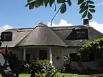 Type of site: House. This is part of the oldest so-called garden city in South Africa. |
| 9/2/031/0001/010 | 11 The Mead, Pinelands, Cape Town | Cape Town, Pinelands | Goodwood | Provincial Heritage Site | 33°56′29″S 18°29′48″E / 33.941295°S 18.496577°E |  | |
| 9/2/031/0001/011 | 15 The Mead, Pinelands, Cape Town | Type of site: House. This is part of the oldest so-called garden city in South Africa. | Cape Town, Pinelands | Goodwood | Provincial Heritage Site | 33°56′28″S 18°29′48″E / 33.940984°S 18.496803°E | 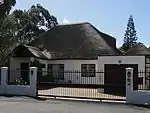 Type of site: House. This is part of the oldest so-called garden city in South Africa. |
| 9/2/031/0001/012 | 5 The Mead, Pinelands, Cape Town | Type of site: House. This is part of the oldest so-called garden city in South Africa. | Cape Town, Pinelands | Goodwood | Provincial Heritage Site | 33°56′20″S 18°29′29″E / 33.938935°S 18.491388°E | 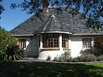 Type of site: House. This is part of the oldest so-called garden city in South Africa. |
| 9/2/031/0001/013 | 2 Meadway, Pinelands, Cape Town | Type of site: House. This is part of the oldest so-called garden city in South Africa. | Cape Town, Pinelands | Goodwood | Provincial Heritage Site | 33°56′32″S 18°29′52″E / 33.942225°S 18.497722°E | 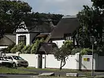 Type of site: House. This is part of the oldest so-called garden city in South Africa. |
| 9/2/031/0001/014 | 10 Meadway, Pinelands, Cape Town | Type of site: House. Historical and architectural interest
The Pinelands Garden City originated with Richard Stuttaford, who actively promoted this new concept. The town planner and architect Albert J. Thompson drew up the plans in 1919. |
Cape Town, Pinelands | Goodwood | Provincial Heritage Site | 33°56′18″S 18°29′34″E / 33.938389°S 18.492764°E | Upload Photo |
| 9/2/031/0001/016 | 14 Meadway, Pinelands, Cape Town | Type of site: House This is part of the oldest so-called garden city in South Africa. | Cape Town, Pinelands | Goodwood | Provincial Heritage Site | 33°56′27″S 18°29′52″E / 33.940926°S 18.497766°E | 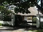 Type of site: House This is part of the oldest so-called garden city in South Africa. |
| 9/2/031/0001/017 | 9 The Mead, Pinelands, Cape Town | Type of site: House This is part of the oldest so-called garden city in South Africa. | Cape Town, Pinelands | Goodwood | Provincial Heritage Site | 33°56′29″S 18°29′48″E / 33.941511°S 18.496577°E | 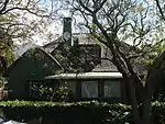 Type of site: House This is part of the oldest so-called garden city in South Africa. |
| 9/2/031/0001/018 | 8 The Mead, Pinelands | Type of site: House This is one of the oldest garden cities in South Africa. | Cape Town, Pinelands | Goodwood | Provincial Heritage Site | 33°56′29″S 18°29′52″E / 33.941521°S 18.497857°E |  Type of site: House This is one of the oldest garden cities in South Africa. |
| 9/2/031/0001/019 | The Mead Open Space and Meadway Road Reserve, Pinelands | This is one of the oldest garden cities in South Africa | Cape Town, Pinelands | Goodwood | Provincial Heritage Site | 33°56′30″S 18°29′51″E / 33.941691°S 18.497382°E | This is one of the oldest garden cities in South Africa |
| 9/2/031/0001/15 | No 6, Meadway, Pinelands, Goodwood District | Goodwood | Goodwood | 33°56′30″S 18°29′52″E / 33.941742°S 18.497889°E | Upload Photo | ||
| 9/2/031/0002 | Maitland Cemetery, Voortrekker Road, Maitland | Maitland | Goodwood | 33°55′06″S 18°31′18″E / 33.918401°S 18.521764°E | Upload Photo | ||
| 9/2/031/0003 | Alexandra Hospital, Maitland | Maitland | Goodwood | 33°55′45″S 18°29′08″E / 33.929086°S 18.485553°E | Upload Photo | ||
| 9/2/031/0003/1 | De Nieuwe Molen, Alexandra Hospital, Maitland | Maitland | Goodwood | Upload Photo | |||
| 9/2/031/0004 | GOODWOOD MUNICIPAL AREA, GENERAL | Goodwood | Goodwood | Upload Photo | |||
| 9/2/031/0005 | MAITLAND, GOODWOOD DISTRICT, GENERAL | Maitland | Goodwood | Upload Photo | |||
| 9/2/031/0006 | Woltemade Cricket Field, Pinelands | Pinelands | Goodwood | 33°55′19″S 18°30′30″E / 33.921989°S 18.508309°E | Upload Photo | ||
| 9/2/031/0007 | Milestone IV, Voortrekker Road, Maitland | Maitland | Goodwood | Upload Photo | |||
| 9/2/031/0008 | GOODWOOD MAGISTERIAL DISTRICT, GENERAL | Goodwood | Goodwood | Upload Photo | |||
| 9/2/031/0009 | PINELANDS LOCAL AREA, GENERAL | Pinelands | Goodwood | Upload Photo | |||
| 9/2/031/0010 | NDABENI LOCAL AREA, GENERAL | Ndabeni | Goodwood | Upload Photo | |||
| 9/2/031/0011 | 100 Caledon Street, Goodwood | Goodwood | Goodwood | Register | 33°54′28″S 18°32′31″E / 33.907639°S 18.541952°E | Upload Photo | |
| 9/2/031/0012 | 61 Fitzroy Street, Goodwood, Cape Town | Cape Town, Goodwood | Goodwood | Register | 33°54′33″S 18°32′43″E / 33.909217°S 18.545208°E |  | |
| 9/2/031/0013 | 65 Fitzroy Street, Goodwood, Cape Town | Cape Town, Goodwood | Goodwood | Register | 33°54′32″S 18°32′43″E / 33.908940°S 18.545147°E |  | |
| 9/2/031/0014 | 39 Goodwood Street, Goodwood, Cape Town | Cape Town, Goodwood | Goodwood | Register | 33°54′38″S 18°32′53″E / 33.910431°S 18.548037°E |  | |
| 9/2/031/0015 | 41 Goodwood Street, Goodwood, Cape Town | Cape Town, Goodwood | Goodwood | Register | 33°54′37″S 18°32′53″E / 33.910278°S 18.547992°E | Upload Photo | |
| 9/2/031/0016 | 43 Church Street, Goodwood | Goodwood | Goodwood | Register | 33°54′34″S 18°32′58″E / 33.909331°S 18.549431°E | Upload Photo | |
| 9/2/031/0017 | WINGFIELD LOCAL AREA, GENERAL | Goodwood | Goodwood | Upload Photo | |||
| 9/2/031/0018 | Goodwood Museum, cnr Church and Merriman Streets, Goodwood | Goodwood | Goodwood | 33°54′34″S 18°32′58″E / 33.909331°S 18.549431°E | Upload Photo | ||
| 9/2/039/0001 | Doornboom, cnr Fourie & Rall Streets, Heidelberg | Heidelberg | Heidelberg | 34°05′17″S 20°57′38″E / 34.088124°S 20.960460°E | Upload Photo | ||
| 9/2/039/0002 | HEIDELBERG MUNICIPAL AREA, GENERAL | Heidelberg | Heidelberg | Upload Photo | |||
| 9/2/039/0003 | Vermaaklikheid, Heidelberg District | Heidelberg | Heidelberg | 34°18′10″S 21°01′35″E / 34.302800°S 21.026499°E | Upload Photo | ||
| 9/2/039/0004 | Barry Church, Port Beaufort | This church was built by the Barry family in 1849 as an interdenominational chapel for the inhabitants of Port Beaufort.
Port Beaufort lies at the mouth of the Breede River.
Here the little Barry church stands as a memorial to the busy industry that once flourished there.
|
Port Beaufort | Heidelberg | Provincial Heritage Site | 34°08′40″S 20°51′32″E / 34.144491°S 20.858864°E | 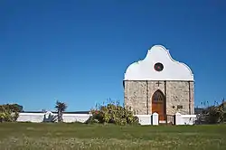 This church was built by the Barry family in 1849 as an interdenominational chapel for the inhabitants of Port Beaufort.
Port Beaufort lies at the mouth of the Breede River.
Here the little Barry church stands as a memorial to the busy industry that once flourished there.
Type of site: Church Current use: Church. |
| 9/2/039/0005 | Benjamin Moodie Memorial, Barracouta Street, Witsand | Type of site: Memorial. Benjamin Moodie, his brothers and their descendants have from 1817 contributed to the development of Southern Africa.
At his own initiative Moodie brought to the Cape the first large group of settlers from the British Isles. |
Witsand | Heidelberg | Register | 34°23′43″S 20°50′38″E / 34.395278°S 20.843786°E | Upload Photo |
| 9/2/039/0006 | Slangrivier, Meerlust, Heidelberg District | Heidelberg | Heidelberg | 34°08′15″S 20°51′43″E / 34.137389°S 20.861947°E | Upload Photo | ||
| 9/2/039/0007 | Dutch Reformed Church, Church Square, Heidelberg | The corner stone of this impressive cruciform church was laid on 13 February 1913 and the building was officially inaugurated on 7 March 1914.
It is the third church building to be erected on this site since the founding of the Dutch Reformed Congregation
|
Heidelberg | Heidelberg | Provincial Heritage Site | 34°06′07″S 20°57′58″E / 34.101940°S 20.966107°E | Upload Photo |
| 9/2/039/0008 | Krombeksrivier Homestead, Heidelberg District | This farmhouse, built predominantly in the Cape Dutch style, was erected in about 1740—1744.
The Krombeksrivier homestead is not only one of the oldest farmhouses in the vicinity but also one of the earliest outspans on the road to the eastern frontier. |
Heidelberg | Provincial Heritage Site | 34°05′04″S 20°56′55″E / 34.084574°S 20.948696°E | Upload Photo | |
| 9/2/039/0009 | Southey's Arms, Glamorgan, Heidelberg District | Heidelberg | Provincial Heritage Site | 34°05′06″S 20°58′27″E / 34.085010°S 20.974274°E | Upload Photo | ||
| 9/2/039/0010 | HEIDELBERG MAGISTERIAL DISTRICT, GENERAL | Heidelberg | Heidelberg | Upload Photo | |||
| 9/2/039/0011 | Groot Vaders Bosch, Heidelberg District | Heidelberg | Heidelberg | Upload Photo | |||
| 9/2/039/0012 | Westfield, Heidelberg District | Heidelberg | Heidelberg | Upload Photo | |||
| 9/2/039/0013 | WITSAND MUNICIPAL AREA, HEIDELBERG DISTRICT, GENERAL | Witsand | Heidelberg | Upload Photo | |||
| 9/2/040/0001 | HERMANUS MUNICIPAL AREA, GENERAL | Hermanus | Hermanus | Upload Photo | |||
| 9/2/040/0002 | Proposed "HMS Birkenhead" memorial, Danger Point, Hermanus District | Danger Point | Hermanus | Upload Photo | |||
| 9/2/040/0003 | Die Kelders Caves, Klipgat, Hermanus District | Hermanus | Hermanus | Pending Declaration | Upload Photo | ||
| 9/2/040/0004 | Stanford House, 20 Queen Victoria Street, Hermanus | Hermanus | Hermanus | 34°26′21″S 19°27′20″E / 34.439289°S 19.455627°E | Upload Photo | ||
| 9/2/040/0005 | STANFORD MUNICIPAL AREA, HERMANUS DISTRICT, GENERAL | Stanford | Hermanus | Upload Photo | |||
| 9/2/040/0006 | Burgundy Restaurant, Hermanus | Type of site: Restaurant These two fishermen's cottages in the vernacular style date from the nineteenth century and are among the earliest buildings erected in Hermanus. | Hermanus | Hermanus | Provincial Heritage Site | 34°25′15″S 19°14′35″E / 34.420789°S 19.242975°E | 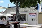 Type of site: Restaurant These two fishermen's cottages in the vernacular style date from the nineteenth century and are among the earliest buildings erected in Hermanus. |
| 9/2/040/0007 | 4 De Villiers Street, Onrus River | The building is said to be the first in Onrus River.
It is a good example of its type – being a simple long stone dwelling. Together with the properties located at 6 & 8 De Villiers Street it forms the core of the old properties in Onrusrivier. |
Onrus River | Hermanus | Register | 34°24′53″S 19°10′24″E / 34.414728°S 19.173222°E | Upload Photo |
| 9/2/040/0008 | 6 De Villiers Street, Onrus River | The building is a late Victorian seaside house, twinned with its neighbour, 8 de Villiers Street (which is currently being investigated with a view to a possible recommendation that it be declared).
Together with the properties located at 4 & 8 De Villiers Street it forms the core of the old properties in Onrusrivier. |
Onrus River | Hermanus | Register | 34°24′52″S 19°10′23″E / 34.414480°S 19.173047°E | Upload Photo |
| 9/2/040/0009 | 8 De Villiers Street, Onrus River | The house is an excellent example of a late 19th / early 20th century purpose built holiday house – one of only a few along this coast.
The house is largely in its original condition. One of the owners, Mr C Joel Krige, was a well-known local politician. Together with the properties located at 4 & 6 De Villiers Street it forms the core of the old properties in Onrusrivier. |
Onrus River | Hermanus | Register | 34°24′53″S 19°10′22″E / 34.414593°S 19.172753°E | Upload Photo |
| 9/2/040/0010 | Windheuwel Farm, Hermanus District | Hermanus | Hermanus | Upload Photo | |||
| 9/2/040/0011 | Linkerhandsgat Farm, Hermanus District | Hermanus | Hermanus | Upload Photo | |||
| 9/2/040/0012 | Old Harbour, Hermanus | Type of site: Harbour | Hermanus | Hermanus | Provincial Heritage Site | 34°25′14″S 19°14′38″E / 34.420426°S 19.244026°E | 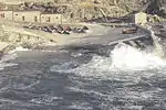 Type of site: Harbour |
| 9/2/040/0013 | HERMANUS MAGISTERIAL DISTRICT, GENERAL | Hermanus | Hermanus | Upload Photo | |||
| 9/2/040/0014 | Danger Point Lighthouse, Hermanus District | Danger Point | Hermanus | 34°37′49″S 19°18′09″E / 34.630163°S 19.302423°E | Upload Photo | ||
| 9/2/040/0014/1 | Birkenhead Memorial Tablet, Danger Point, Hermanus District | Danger Point | Hermanus | Upload Photo | |||
| 9/2/040/0015 | De Kelders Cave & Mineral Spring, Gansbaai, Hermanus District | Gansbaai | Hermanus | National Monument | 34°33′21″S 19°21′51″E / 34.555699°S 19.364238°E | Upload Photo | |
| 9/2/040/0016 | Conservation Area, Stanford, Hermanus District | Stanford | Hermanus | Conservation area | Upload Photo | ||
| 9/2/040/0017 | Proposed Birkenhead Memorial Tablet, Hawston, Hermanus District | Hawston | Hermanus | Upload Photo | |||
| 9/2/040/0018 | ONRUSRIVIER LOCAL AREA, GENERAL | Onrusrivier | Hermanus | Upload Photo | |||
| 9/2/040/0019 | Old Whaling Station, Stony Point, Betty's Bay, Hermanus District | Betty's Bay | Hermanus | 34°22′17″S 18°53′35″E / 34.371434°S 18.893007°E | Upload Photo | ||
| 9/2/040/0020 | Godfrey cottages, Erven 822, 6190 & 6191, Hermanus | Hermanus | Hermanus | Pending Declaration | Upload Photo | ||
| 9/2/040/0021 | GANSBAAI MUNICIPAL AREA, GENERAL | Gansbaai | Hermanus | Upload Photo | |||
| 9/2/040/0022 | Site of Leper Colony, Hemel-en-aarde, Hermanus District | Hemel-en-aarde | Hermanus | Upload Photo | |||
| 9/2/040/0023 | HAWSTON LOCAL AREA, GENERAL | Hawston | Hermanus | Upload Photo | |||
| 9/2/042/0001 | Geelbek, Hopefield District | Geelbek | Hopefield | 33°11′43″S 18°07′24″E / 33.195336°S 18.123284°E |  | ||
| 9/2/042/0001/001 | Farmstead, Geelbek 360, Hopefield District | Type of site: Farm Complex | Hopefield | Provincial Heritage Site | 33°11′45″S 18°07′30″E / 33.195833°S 18.125000°E | Type of site: Farm Complex | |
| 9/2/042/0001/002 | VOC Beacon, Geelbek 360, Hopefield District | About 500 m north-east of the farmhouse and not far from the shore of the la goon there stands in the grassy veld about 35 steps from a row of gumtrees, a beacon of blue-black Malmesbury shale with the inscription G \VOC (Geoktrooieerde Verenigde Oos-Indi This black slate stone beacon with the inscription G VOC chiselled thereon was presumably erected in 1785 by Governor Cornelis Jacobus van der Graaff to indicate the western boundary of the Cape District.
The farm Geelbek, earlier called Geelbekefontein,
|
Hopefield | Provincial Heritage Site | 33°11′45″S 18°07′30″E / 33.195833°S 18.125000°E | About 500 m north-east of the farmhouse and not far from the shore of the la goon there stands in the grassy veld about 35 steps from a row of gumtrees, a beacon of blue-black Malmesbury shale with the inscription G \VOC (Geoktrooieerde Verenigde Oos-Indi This black slate stone beacon with the inscription G VOC chiselled thereon was presumably erected in 1785 by Governor Cornelis Jacobus van der Graaff to indicate the western boundary of the Cape District.
The farm Geelbek, earlier called Geelbekefontein,
Type of site: Beacon | |
| 9/2/042/0001/1 | Farmstead, Geelbek, Hopefield District | Geelbek | Hopefield | National Monument | 33°11′40″S 18°07′31″E / 33.194336°S 18.125258°E | Upload Photo | |
| 9/2/042/0001/2 | VOC Beacon, Geelbek, Hopefield District | Geelbek | Hopefield | National Monument | Upload Photo | ||
| 9/2/042/0002 | Bottelary, West Coast National Park, Langebaan, Hopefield District | Langebaan | Hopefield | 33°08′00″S 18°06′00″E / 33.133218°S 18.100087°E | Upload Photo | ||
| 9/2/042/0003 | LANGEBAAN MUNICIPAL AREA, GENERAL | Langebaan | Hopefield | Upload Photo | |||
| 9/2/042/0004 | HOPEFIELD MUNICIPAL AREA, GENERAL | Hopefield | Hopefield | Upload Photo | |||
| 9/2/042/0005 | Old Whaling Station, Salamander Bay, Hopefield District | Salamander Bay | Hopefield | Upload Photo | |||
| 9/2/042/0005/1 | Cemetery, Old Whaling Station, Salamander Bay, Hopefield District | Salamander Bay | Hopefield | Upload Photo | |||
| 9/2/042/0007 | Meeuwenklip, Egret Street, Langebaan, Hopefield District | Langebaan | Hopefield | Upload Photo | |||
| 9/2/042/0008 | Dutch Reformed Church, Oostewal Street, Langebaan | This church with its Neo-Gothic features was donated to the parish of Hopefield in 1872 as a chapel of ease by a member of the congregation, Mr Willem van der Byl.
The church building was taken into use on 1 April 1872.
The yellowwood pulpit inside the church
|
Langebaan | Hopefield | Provincial Heritage Site | 33°05′51″S 18°01′51″E / 33.097551°S 18.030945°E | Upload Photo |
| 9/2/042/0010 | Oosterwal, Hopefield District | The Oesterwal complex is a typical West Coast farm complex in simple vernacular style architecture with straight end gables and parapets.
It consists of a large quadrangled structure which was originally an H-shaped house altered to serve as Residency
|
Hopefield | Provincial Heritage Site | 33°07′10″S 18°03′15″E / 33.119444°S 18.054166°E | Upload Photo | |
| 9/2/042/0011 | HOPEFIELD MAGISTERIAL DISTRICT, GENERAL | Hopefield | Hopefield | Upload Photo | |||
| 9/2/042/0011/1 | Coastal archaeology, Hopefield District | Hopefield | Hopefield | Upload Photo | |||
| 9/2/042/0012 | Langrietvlei, Hopefield District | Hopefield | Hopefield | National Monument | 32°52′23″S 18°13′28″E / 32.873183°S 18.224445°E | 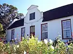 | |
| 9/2/042/0012-001 | Homestead, Langrietvlei 72, Hopefield District | Granted in 1715 to Hendrik Oostwald Eksteen.
When Lichtenstein and Holman stopped at the farm it belonged to Jacob Laubscher.
It has been in the Kotze family since 1834.
This T-shaped Cape Dutch house, with its impressive concavo-convex gables, was probably erected in 1789. At that time the property belonged to Jacob Laubscher who, according to Lichtenstein, was one of the most prosperous colonists in the country.
|
Hopefield | Provincial Heritage Site | 32°53′20″S 18°16′15″E / 32.888888°S 18.270833°E | Granted in 1715 to Hendrik Oostwald Eksteen.
When Lichtenstein and Holman stopped at the farm it belonged to Jacob Laubscher.
It has been in the Kotze family since 1834.
This T-shaped Cape Dutch house, with its impressive concavo-convex gables, was probably erected in 1789. At that time the property belonged to Jacob Laubscher who, according to Lichtenstein, was one of the most prosperous colonists in the country.
Type of site: House Current use: Dwelling. | |
| 9/2/042/0013 | Oude Post Fortification, Langebaan Lagoon, Hopefield District | Hopefield | Hopefield | Pending Declaration | Upload Photo | ||
| 9/2/042/0014 | Langebaanweg quarry fossil site, Hopefield District | Hopefield | Provincial Heritage Site | 32°57′54″S 18°06′51″E / 32.964963°S 18.114138°E |  | ||
| 9/2/042/0015 | Oude Post 11, Hopefield District | Hopefield | Hopefield | Pending Declaration | Upload Photo | ||
| 9/2/042/0016 | Elandsfontein Farm, Hopefield District | Hopefield | Hopefield | 33°05′39″S 18°12′08″E / 33.094291°S 18.202092°E | Upload Photo | ||
| 9/2/042/0017 | Fossilised Footprints, Langebaan Lagoon | Langebaan | Hopefield | Upload Photo | |||
| 9/2/054/0001 | KUILS RIVER MUNICIPAL AREA, GENERAL | Kuils River | Kuils River | Upload Photo | |||
| 9/2/054/0002 | Saxenbug, Kuils River District | Kuils River | Kuils River | 33°56′48″S 18°43′08″E / 33.946733°S 18.718783°E | Upload Photo | ||
| 9/2/054/0003 | Hazendal, Bottelary Road, Kuils River District | Kuils River | Provincial Heritage Site | 33°54′10″S 18°42′12″E / 33.902905°S 18.703420°E |  | ||
| 9/2/054/0004 | Zevenfontein, Kuils River District | Type of site: Farmstead This fine Old-Cape house with its attractive front gable and garden wall was built about 1800. | Kuils River | Provincial Heritage Site | 33°56′19″S 18°42′28″E / 33.938646°S 18.707646°E | Upload Photo | |
| 9/2/054/0005 | Milestone XV, Kuils River Municipality, Kuils River | This elongated sandstone milestone, with the Roman numerals XV thereon, presumably dates from the late eighteenth or early nineteenth century and was previously situated on the road between Bellville and Kuils River.
|
Kuils River | Kuils River | Provincial Heritage Site | 33°55′36″S 18°40′48″E / 33.926594°S 18.680052°E | This elongated sandstone milestone, with the Roman numerals XV thereon, presumably dates from the late eighteenth or early nineteenth century and was previously situated on the road between Bellville and Kuils River.
Type of site: Milestone |
| 9/2/054/0006 | Leeuwenhof, 6 Bosman Street, Kuils River | Kuils River | Kuils River | 33°55′16″S 18°40′39″E / 33.921108°S 18.677412°E | Upload Photo | ||
| 9/2/054/0007 | KUILS RIVER MAGISTERIAL DISTRICT, GENERAL | Kuils River | Kuils River | Upload Photo | |||
| 9/2/054/0008 | BRACKENFELL LOCAL AREA, GENERAL | Brackenfell | Kuils River | Upload Photo | |||
| 9/2/054/0009 | KRAAIFONTEIN LOCAL AREA | Kraaifontein | Kuils River | Upload Photo | |||
| 9/2/054/0010 | Mooiplaas, Kuils River District | Type of site: Farm Complex | Kuils River | Provincial Heritage Site | 33°56′34″S 18°41′37″E / 33.942915°S 18.693581°E |  Type of site: Farm Complex | |
| 9/2/056/0001 | Olyve River, Van Wyksdorp, Ladismith District | Ladismith | Ladismith | Upload Photo | |||
| 9/2/056/0002 | 76 Albert Street, Ladismith | Van Wyksdorp | Ladismith | 33°29′34″S 21°16′09″E / 33.492827°S 21.269296°E | Upload Photo | ||
| 9/2/056/0003 | LADISMITH MUNICIPAL AREA, GENERAL | Ladismith | Ladismith | Upload Photo | |||
| 9/2/056/0004 | Old Dutch Reformed Church, Church Street, Ladismith | This church was consecrated on 30 May 1874.
It was designed and built in the neo-Gothic style by the well-known architect Carl Otto Hager.
|
Ladismith | Ladismith | Provincial Heritage Site | 33°29′36″S 21°15′56″E / 33.493351°S 21.265423°E |  This church was consecrated on 30 May 1874.
It was designed and built in the neo-Gothic style by the well-known architect Carl Otto Hager.
Type of site: Church Previous use: Church. Current use: Vacant. |
| 9/2/056/0005 | Anglican Church, Ladismith | Ladismith | Ladismith | Upload Photo | |||
| 9/2/056/0005/1 | Grave in churchyard of Anglican Church, Ladismith | Ladismith | Ladismith | Upload Photo | |||
| 9/2/056/0007 | Van Wyksdorp Military Graves, Van Wyksdorp | Van Wyksdorp | Ladismith | Upload Photo | |||
| 9/2/056/0008 | Town Cemetery, Van Wyksdorp, Ladismith | Van Wyksdorp | Ladismith | Upload Photo | |||
| 9/2/056/0009 | Amalienstein Mission Complex, Ladismith District | Type of site: Mission Station | Amalienstein | Ladismith | Provincial Heritage Site | 33°29′00″S 21°28′00″E / 33.483333°S 21.466667°E |  Type of site: Mission Station |
| 9/2/056/0009/001 | Church, Amalienstein Mission Complex, Ladismith District | Type of site: Church | Amalienstein | Ladismith | Provincial Heritage Site | 33°29′00″S 21°28′00″E / 33.483333°S 21.466667°E | Type of site: Church |
| 9/2/056/0009/1 | Lutheran Church Building, Amalienstein, Ladismith District | Ladismith | Ladismith | Upload Photo | |||
| 9/2/056/0009/2 | Cemetery, Amalienstein Mission Complex, Ladismith District | Ladismith | Ladismith | Upload Photo | |||
| 9/2/056/0010 | Lutheran Church complex, Church Street, Ladismith | Type of site: Church Complex | Ladismith | Ladismith | Provincial Heritage Site | 33°29′07″S 21°15′56″E / 33.485334°S 21.265423°E |  Type of site: Church Complex |
| 9/2/056/0010/1 | Lutheran Church, Church Street, Ladismith | Ladismith | Ladismith | National Monument | Upload Photo | ||
| 9/2/056/0010/2 | Old Lutheran Church Parsonage, Church Street, Ladismith | Ladismith | Ladismith | National Monument | Upload Photo | ||
| 9/2/056/0010/3 | Lutheran Church Hall, Church Street, Ladismith | Ladismith | Ladismith | National Monument | Upload Photo | ||
| 9/2/056/0010/4 | Lutheran Church Offices, Church Street, Ladismith | Ladismith | Ladismith | National Monument | Upload Photo | ||
| 9/2/056/0011 | Old Wesleyan Church, Becker Street, Ladismith | Type of site: Church.
|
Ladismith | Ladismith | Provincial Heritage Site | 33°29′35″S 21°15′52″E / 33.493181°S 21.264369°E |  Type of site: Church.
Current use: Church. |
| 9/2/056/0012 | Fossil site, Besemfontein, Ladismith District | Ladismith | Ladismith | Upload Photo | |||
| 9/2/056/0013 | Oakdene, 50 Church Street, Ladismith | This stately double-storeyed house was erect by the immigrant Heinrich Wilhelm Becker in 1876.
He was Mayor of Ladismith for an unbroken period of 32 years.
|
Ladismith | Ladismith | Provincial Heritage Site | 33°29′35″S 21°15′56″E / 33.493154°S 21.265498°E | 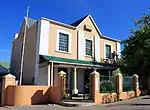 This stately double-storeyed house was erect by the immigrant Heinrich Wilhelm Becker in 1876.
He was Mayor of Ladismith for an unbroken period of 32 years.
Type of site: House Current use: Residential. This stately double-storeyed house was erect by the immigrant Heinrich Wilhelm Becker in 1876. He was Mayor of Ladismith for an unbroken period of 32 years. |
| 9/2/056/0014 | 58 Church Street, Ladismith | Ladismith | Ladismith | Provincial Heritage Site | 33°29′48″S 21°15′52″E / 33.4966722222°S 21.2645444444°E |  | |
| 9/2/056/0015 | 19 Queen Street, Ladismith | Ladismith | Ladismith | Provincial Heritage Site | 33°29′37″S 21°16′02″E / 33.493678°S 21.267248°E | Upload Photo | |
| 9/2/056/0016 | Birthplace of C J Langenhoven, Hoeko, Ladismith District | Ladismith | Ladismith | Upload Photo | |||
| 9/2/056/0017 | Seweweekspoort, Ladismith District | Ladismith | Ladismith | 33°24′01″S 21°24′00″E / 33.400246°S 21.400005°E | Upload Photo | ||
| 9/2/056/0018 | Albert Manor, 44 Albert Street, Ladismith | Type of site: Residence.
|
Ladismith | Ladismith | Provincial Heritage Site | 33°29′38″S 21°16′09″E / 33.493825°S 21.269107°E |  Type of site: Residence.
Previous use: Residence. Current use: Guest House. |
| 9/2/056/0019 | Hoffland House, Church Street, Ladismith | Ladismith | Ladismith | Upload Photo | |||
| 9/2/056/0020 | LADISMITH MAGISTERIAL GENERAL | Ladismith | Ladismith | Upload Photo | |||
| 9/2/056/0021 | ZOAR LOCAL AREA | Ladismith | Ladismith | Upload Photo | |||
| 9/2/056/0022 | Military Graves, Van Zylsdam Farm, Ladismith District | Ladismith | Ladismith | Upload Photo | |||
| 9/2/058/0001 | Matjiesfontein Village, Laingsburg District | Victorian village developed as health resort by James Logan in the 1880s.
Used as military base and hospital by British forces in Anglo-Boer War.
Entire village bought in 1965 by David Rawdon and redeveloped.
|
Matjiesfontein | Laingsburg | Provincial Heritage Site | 33°13′51″S 20°34′57″E / 33.230735°S 20.582626°E |  Victorian village developed as health resort by James Logan in the 1880s.
Used as military base and hospital by British forces in Anglo-Boer War.
Entire village bought in 1965 by David Rawdon and redeveloped.
Type of site: Village Turn off from N1. Village is 1 km from turn-off. The historic Matjiesfontein Village was built between 1895 and 1907 by Mr J. Logan. It was developed as a spa and as such it became the meeting place of historical figures like Cecil Rhodes and Olive Schreiner. |
| 9/2/058/0002 | Railway Station building, Matjiesfontein, Laingsburg District | Type of site: Railway Station
|
Matjiesfontein | Laingsburg | Provincial Heritage Site | 33°13′53″S 20°34′57″E / 33.231358°S 20.582494°E | 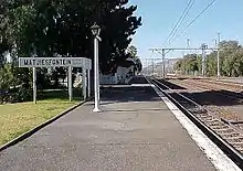 Type of site: Railway Station
Current use: Railway station. |
| 9/2/058/0003 | Dutch Reformed Church, Voortrekker Street, Laingsburg | Stone church with plaster decoration and corrugated iron roof.
Square tower with squat spire.
First church building consecrated 1881.
Congregation established 6 December 1882.
Second building designed by W H Ford, consecrated 20 April 1905.
Damaged by flood waters in 1981.
Restored by Gabriel Fagan.
Commemorative plaque unveiled 5 Dec 1982.
|
Laingsburg | Laingsburg | Provincial Heritage Site | 33°11′42″S 20°51′06″E / 33.195117°S 20.851648°E | 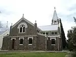 Stone church with plaster decoration and corrugated iron roof.
Square tower with squat spire.
First church building consecrated 1881.
Congregation established 6 December 1882.
Second building designed by W H Ford, consecrated 20 April 1905.
Damaged by flood waters in 1981.
Restored by Gabriel Fagan.
Commemorative plaque unveiled 5 Dec 1982.
Type of site: Church Previous use: Church. Current use: Church : Dutch Reformed. |
| 9/2/058/0004 | Matjiesfontein Cemetery, Pieter Meintjiesfontein, Laingsburg District | A small cemetery containing the graves of, amongst others, Maj Gen A G Wauchope and James Logan.
|
Laingsburg | Provincial Heritage Site | 33°14′00″S 20°35′16″E / 33.233351°S 20.587645°E | 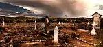 A small cemetery containing the graves of, amongst others, Maj Gen A G Wauchope and James Logan.
Type of site: Graveyard East of N1 and south of Koppie approx 10 kilometres south of Matjiesfontein. | |
| 9/2/058/0005 | Municipal Cemetery, Laingsburg | Laingsburg | Laingsburg | Pending Declaration | Upload Photo | ||
| 9/2/058/0006 | LAINGSBURG MUNICIPAL AREA, GENERAL | Laingsburg | Laingsburg | Upload Photo | |||
| 9/2/058/0007 | Anglo-Boer War blockhouse, Geelbek River, Laingsburg District | This blockhouse stands some 14 km north of Laingsburg at a point where the national road and the railway line cross a tributary of the Buffalo River.
It is one of the best preserved examples of the blockhouses built during the Anglo-Boer War (1899–1902).
This blockhouse belongs to the type that was erected to protect key positions and especially bridges.
It is a double-storeyed stone building
|
Laingsburg | Provincial Heritage Site | 33°10′32″S 20°59′08″E / 33.175563°S 20.985507°E | 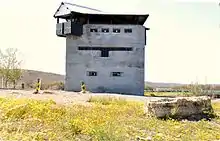 This blockhouse stands some 14 km north of Laingsburg at a point where the national road and the railway line cross a tributary of the Buffalo River.
It is one of the best preserved examples of the blockhouses built during the Anglo-Boer War (1899–1902).
This blockhouse belongs to the type that was erected to protect key positions and especially bridges.
It is a double-storeyed stone building
Type of site: Blockhouse Previous use: Fortification. A very fine example of the blockhouses erected during the Anglo-Boer War. | |
| 9/2/058/0008 | Anysberg Nature Reserve, Laingsburg District | Laingsburg | Laingsburg | National Monument | 33°27′25″S 20°35′27″E / 33.456983°S 20.590875°E | Upload Photo | |
| 9/2/058/0009 | Lutheran Church Complex, Laingsburg | Laingsburg | Laingsburg | Upload Photo | |||
| 9/2/058/0010 | LAINGSBURG MAGISTERIAL DISTRICT, GENERAL | Laingsburg | Laingsburg | Upload Photo | |||
| 9/2/060/0001 | MALMESBURY MUNICIPAL AREA, GENERAL | Malmesbury | Malmesbury | Upload Photo | |||
| 9/2/060/0002 | Oude Kerk Museum, Main Street, Riebeeck-Kasteel | Type of site: Church, Museum
|
Riebeeck-Kasteel | Malmesbury | Provincial Heritage Site | 33°23′00″S 18°53′25″E / 33.3833333333°S 18.8902777777°E | 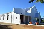 Type of site: Church, Museum
Previous use: Church. Current use: Museum. |
| 9/2/060/0003 | Old Station Building, Arcadia Street, Darling Malmesbury District | Darling | Malmesbury | 33°22′30″S 18°22′58″E / 33.375099°S 18.382824°E | Upload Photo | ||
| 9/2/060/0004 | Mission station, Mamre | The Mission Station was founded in 1808 by Moravian missionaries on the site occupied by the Dutch East India Company's military outpost, "'t Groenekloof", from 1701 to 1791.
The old farm house (now the parsonage) was certainly built before 1770, and the original gable of the church building bears the date 1818, although later it was slightly altered.
|
Mamre | Malmesbury | Provincial Heritage Site | 33°30′45″S 18°28′25″E / 33.512377°S 18.473601°E | 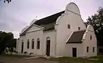 The Mission Station was founded in 1808 by Moravian missionaries on the site occupied by the Dutch East India Company's military outpost, "'t Groenekloof", from 1701 to 1791.
The old farm house (now the parsonage) was certainly built before 1770, and the original gable of the church building bears the date 1818, although later it was slightly altered.
Type of site: Mission Station. The Mission Station which is an important place of interest because of both its history and its architectural beauty, was founded in 1808 by Moravian missionaries on the site occupied by the Dutch East India Company's military outpost, "'t Groenekloof". |
| 9/2/060/0004/001 | Watermill, Mission station, Mamre | This water-mill dates from about 1840 and is an important part of the existing historic building complex of the mission station at Mamre which was founded in 1808.
|
Mamre | Malmesbury | Provincial Heritage Site | 33°30′45″S 18°28′25″E / 33.512377°S 18.473601°E | 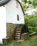 This water-mill dates from about 1840 and is an important part of the existing historic building complex of the mission station at Mamre which was founded in 1808.
Type of site: Water Mill Previous use: Mill. |
| 9/2/060/0005 | see 9/2/112/0007 | Malmesbury | Upload Photo | ||||
| 9/2/060/0006 | see 9/2/112/0010 | Malmesbury | Upload Photo | ||||
| 9/2/060/0007 | Peppertree House, 17 Station Road, Darling, Malmesbury District | Darling | Malmesbury | 33°22′47″S 18°22′47″E / 33.379782°S 18.379610°E | Upload Photo | ||
| 9/2/060/0008 | 20 Station Road, Darling, Malmesbury District | Darling | Malmesbury | 33°22′47″S 18°22′47″E / 33.379826°S 18.379643°E | Upload Photo | ||
| 9/2/060/0009 | Old Police Station, Darling, Malmesbury District | Darling | Malmesbury | Upload Photo | |||
| 9/2/060/0010 | Groote Post, Malmesbury District | In this area Henning Huising had the right to graze his cattle for he was one of the few who had a meat contract with the Company.
These contracts were valuable monopolies and considerable sums were paid for them. It became necessary to establish guards. In 1752 Groote Post was already one of the largest and most important farms in the vicinity of Malmesbury. The impressive homestead and outbuildings date from the early nineteenth century. From 1814 to 1827 it was the country house of Lord Charles Somerset. |
Malmesbury | Provincial Heritage Site | 33°26′50″S 18°24′15″E / 33.4472222222°S 18.4041666666°E |  In this area Henning Huising had the right to graze his cattle for he was one of the few who had a meat contract with the Company.
These contracts were valuable monopolies and considerable sums were paid for them.
It became necessary to establish guards. In 1752 Groote Post was already one of the largest and most important farms in the vicinity of Malmesbury.
The impressive homestead and outbuildings date from the early nineteenth century.
From 1814 to 1827 it was the country house of Lord Charles Somerset. | |
| 9/2/060/0011 | Ganzekraal, Malmesbury District | Malmesbury | Malmesbury | Upload Photo | |||
| 9/2/060/0012 | Loedolf House, 6 Loedolf Street, Malmesbury | Malmesbury | Malmesbury | 33°27′51″S 18°43′56″E / 33.464044°S 18.732100°E |  | ||
| 9/2/060/0013 | Duinefontein, Malmesbury District | Malmesbury | Malmesbury | Upload Photo | |||
| 9/2/060/0014 | Lime kiln, De la Rey, Malmesbury District | This lime kiln is one of two similar structures in the area and one of the few remaining examples of the open kiln type in South Africa.
|
Malmesbury | Provincial Heritage Site | 33°20′30″S 18°13′00″E / 33.3416666666°S 18.2166666666°E |  This lime kiln is one of two similar structures in the area and one of the few remaining examples of the open kiln type in South Africa.
Type of site: Lime kiln | |
| 9/2/060/0015 | Lime kiln, Jacobus Kraal, Malmesbury District | Type of site: Lime kiln This lime kiln is one of two similar structures in the area and one of the few remaining examples of the open kiln type in South Africa. |
Malmesbury | Provincial Heritage Site | 33°20′30″S 18°13′00″E / 33.3416666666°S 18.2166666666°E | 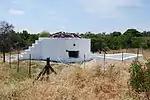 Type of site: Lime kiln This lime kiln is one of two similar structures in the area and one of the few remaining examples of the open kiln type in South Africa. | |
| 9/2/060/0016 | Malmesbury Museum, Prospect Street, Malmesbury | Type of site: Church, Museum
|
Malmesbury | Malmesbury | Provincial Heritage Site | 33°27′58″S 18°43′47″E / 33.466226°S 18.729717°E | 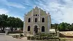 Type of site: Church, Museum
Previous use: Synagogue. Current use: Museum. With a flourishing Jewish community in Malmesbury, the old Synagogue, designed by architect B. Goldman, was built in 1911. After the Jewish community started to diminish, the building was transferred to the Municipality of Malmesbury in 1974. |
| 9/2/060/0017 | Birthplace of General Smuts, Ongegund, Malmesbury District | Birthplace of General J.
C. Smuts, Riebeek West About six kilometres due north of Riebeek West, along the road to Moorreesburg, there is a large cement factory. Right in this industrial development, at the edge of a deep quarry, stands a long, narrow house. Jan Christiaan Smuts was born in this house on 24 May 1870. |
Malmesbury | Provincial Heritage Site | 33°19′25″S 18°51′00″E / 33.3236111111°S 18.85°E | 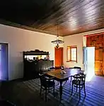 Birthplace of General J.
C.
Smuts, Riebeek West About six kilometres due north of Riebeek West, along the road to Moorreesburg, there is a large cement factory.
Right in this industrial development, at the edge of a deep quarry, stands a long, narrow house. Jan Christiaan Smuts was born in this house on 24 May 1870. | |
| 9/2/060/0018 | Old well, Lewis Stores, 11 Piet Retief Street, Malmesbury | This well is one of three similar structures which was erected in 1751 for the use of communicants on the church square adjoining the original church at Malmesbury.
|
Malmesbury | Malmesbury | Provincial Heritage Site | 33°27′42″S 18°43′51″E / 33.461782°S 18.730807°E | Upload Photo |
| 9/2/060/0019 | Dutch Reformed Church, Kerk Street, Philadelphia | Typical Neo-Gothic cruciform church with decorative corner buttresses.
Square bell tower at entrance.
This imposing church, the nave of which was consecrated in 1864, was enlarged in 1910 by the addition of two wings, the vestibule and the stately tower.
|
Philadelphia | Malmesbury | Provincial Heritage Site | 33°40′00″S 18°35′00″E / 33.6666666666°S 18.5833333333°E | 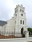 Typical Neo-Gothic cruciform church with decorative corner buttresses.
Square bell tower at entrance.
This imposing church, the nave of which was consecrated in 1864, was enlarged in 1910 by the addition of two wings, the vestibule and the stately tower.
Type of site: Church Current use: Church : Dutch Reformed. Fine example of ecclesiastical building providing an architectural landmark in the village. Historically and culturally significant in the village history. |
| 9/2/060/0020 | New Apostolic Church, 42 Voortrekker Road, Malmesbury | This Neo-Gothic Church, which was designed by Sophia Gray and consecrated in 1859 by Bishop Robert Gray, served the Anglican community until 1975 when a new church was consecrated in Wesbank, resulting in the property being sold to the New Apostolic Church.
|
Malmesbury | Malmesbury | Provincial Heritage Site | 33°27′51″S 18°43′46″E / 33.464217°S 18.729335°E | Upload Photo |
| 9/2/060/0021 | Swartland survey beacon, Klipvlei, Malmesbury District | This pyramid-shaped sandstone beacon, with its mounted platinum pin, forms the western terminal point of Sir Thomas Maclear's Zwartland survey baseline, which was laid in 1840/41.
It is closely associated with the development of surveying in South Africa.
|
Malmesbury | Provincial Heritage Site | 33°16′10″S 18°22′35″E / 33.2694444444°S 18.3763888888°E | Upload Photo | |
| 9/2/060/0022 | Bokkerivier, Bokbaai, Malmesbury District | Type of site: Farm. The farm Bokke Rivier is world-renowned for the Bokbaaivygies, Nemesia and the wealth of other flowers and wild life that flourish there. The farm buildings of Buck Bay are of outstanding historical and aesthetic value. | Malmesbury | Provincial Heritage Site | 33°34′25″S 18°19′30″E / 33.5736111111°S 18.325°E | Upload Photo | |
| 9/2/060/0023 | Dutch Reformed Church, Church Street, Malmesbury | This neo-Gothic church building was officially opened on 30 September 1860.
The tower, which was added in 1864, collapsed in 1877 and was rebuilt in 1880.
The church is closely associated with the establishment of the Swartland congregation, as well as the founding of the town Malmesbury itself.
|
Malmesbury | Malmesbury | Provincial Heritage Site | 33°27′47″S 18°43′48″E / 33.462974°S 18.730048°E |  This neo-Gothic church building was officially opened on 30 September 1860.
The tower, which was added in 1864, collapsed in 1877 and was rebuilt in 1880.
The church is closely associated with the establishment of the Swartland congregation, as well as the founding of the town Malmesbury itself.
Type of site: Church Current use: Church : Dutch Reformed. |
| 9/2/060/0024 | 14 Faure Street, Malmesbury | This magnificent Victorian double-storeyed house was built at the turn of the century of material imported from abroad.
|
Malmesbury | Malmesbury | Provincial Heritage Site | 33°27′41″S 18°43′33″E / 33.461338°S 18.725915°E | .jpg.webp) This magnificent Victorian double-storeyed house was built at the turn of the century of material imported from abroad.
Type of site: House Current use: Dwelling. |
| 9/2/060/0025 | C P Hildebran Grave, Stryderfontin, Malmesbury District | Malmesbury | Malmesbury | Upload Photo | |||
| 9/2/060/0026 | Springfontein, Malmesbury District | Malmesbury | Malmesbury | Upload Photo | |||
| 9/2/060/0027 | Klipheuwel Pinkster Tabernakel, San Remo Road, Klipheuwel, Malmesbury | Malmesbury | Malmesbury | Upload Photo | |||
| 9/2/060/0028 | MALMESBURY MAGISTERIAL DISTRICT, GENERAL | Malmesbury | Malmesbury | Upload Photo | |||
| 9/2/060/0029 | Klawervallei, Malmesbury District | Malmesbury | Provincial Heritage Site | 33°26′56″S 18°43′18″E / 33.448756°S 18.721733°E | Upload Photo | ||
| 9/2/060/0030 | PHILADELPHIA LOCAL AREA, GENERAL | Malmesbury | Malmesbury | Upload Photo | |||
| 9/2/060/0031 | Rondeberg Farm, Malmesbury District | Malmesbury | Malmesbury | 33°25′07″S 18°17′58″E / 33.418688°S 18.299575°E | Upload Photo | ||
| 9/2/060/0032 | Loedolf Stree Precinct, Malmesbury | Malmesbury | Malmesbury | Upload Photo | |||
| 9/2/060/0033 | Goedgedacht, Ptn 1 of Farm 1064, Malmesbury District | Malmesbury | Malmesbury | Upload Photo | |||
| 9/2/060/0034 | RIEBEECK WEST LOCAL AREA, GENERAL | Riebeeck West | Malmesbury | Upload Photo | |||
| 9/2/060/0035 | Trafalgar House Precinct, Block Bounded by Church, Rainier, Loedolf & Riebeeck Streets, Malmesbury | Malmesbury | Malmesbury | 33°27′49″S 18°43′54″E / 33.463649°S 18.731591°E | Upload Photo | ||
| 9/2/060/0036 | BOTTERBERG LOCAL AREA, GENERAL | Botterberg | Malmesbury | Upload Photo | |||
| 9/2/060/0037 | KALBASKRAAL LOCAL AREA, GENERAL | Kalbaskraal | Malmesbury | Upload Photo | |||
| 9/2/060/0038 | DARLING LOCAL AREA GENERAL | Darling | Malmesbury | Upload Photo | |||
| 9/2/060/0039 | RIEBEECK KASTEEL LOCAL AREA, GENERAL, Malmesbury District | Riebeeck Kasteel | Malmesbury | Upload Photo | |||
| 9/2/060/0040 | PELLA LOCAL AREA GENERAL, Malmesbury District | Pella | Malmesbury | Upload Photo | |||
| 9/2/065/0001 | MURRAYSBURG MAGISTERIAL DISTRICT, GENERAL | Murraysburg | Murraysburg | Upload Photo | |||
| 9/2/065/0002 | MURRAYSBURG MUNICIPAL AREA, GENERAL | Murraysburg | Murraysburg | Upload Photo | |||
| 9/2/065/0003 | Victorian Cottage, 33 Darling Street, Murraysburg | Murraysburg | Murraysburg | 31°57′40″S 23°45′40″E / 31.961013°S 23.761009°E | Upload Photo | ||
| 9/2/065/0004 | Old Powder Magazine, Murraysburg | This powder magazine was erected in 1878 on land which was granted to the Municipality by the local church council in 1859.
The powder magazine is a simple, rectangular structure with two gables on both sides and a solid copper door in front. |
Murraysburg | Murraysburg | Provincial Heritage Site | 31°57′34″S 23°46′04″E / 31.959556°S 23.767886°E | Upload Photo |
| 9/2/065/0005 | Military Graves, Vleiplaats | Murraysburg | Murraysburg | Upload Photo | |||
| 9/2/065/0007 | Military Graves, Stellenboschvlei, Murraysburg District | Murraysburg | Murraysburg | Upload Photo | |||
| 9/2/068/0001 | Cango Caves, De Kombuis, Oudtshoorn District | This famous attraction is situated in the Cango ward 29 kilometres north of Oudtshoorn.
The entrance is in the face of a hill beside the Grobbelaar's River.
The maze of caves with their beautiful stalactite formations are most impressive.
It is generally accepted that the Caves were discovered in 1780 by a herdsman of a farmer called Van Zyl of Doornrivier (now Herold) while he was looking for lost cattle.
Later, this man paid a second visit to the caves accompanied by a schoolmaster.
|
Oudtshoorn | Provincial Heritage Site | 33°23′32″S 22°12′52″E / 33.392290°S 22.214380°E |  This famous attraction is situated in the Cango ward 29 kilometres north of Oudtshoorn.
The entrance is in the face of a hill beside the Grobbelaar's River.
The maze of caves with their beautiful stalactite formations are most impressive.
It is generally accepted that the Caves were discovered in 1780 by a herdsman of a farmer called Van Zyl of Doornrivier (now Herold) while he was looking for lost cattle.
Later, this man paid a second visit to the caves accompanied by a schoolmaster.
Type of site: Karst cavern | |
| 9/2/068/0002 | Arbeidsgenot, 217 Jan van Riebeeck Road, Oudtshoorn | Oudtshoorn | Oudtshoorn | Provincial Heritage Site | 33°35′10″S 22°11′41″E / 33.586120°S 22.194635°E |  | |
| 9/2/068/0003 | Rus-in-Urbe, Oudtshoorn | Type of site: House | Oudtshoorn | Oudtshoorn | Provincial Heritage Site | 33°36′03″S 22°12′09″E / 33.600723°S 22.202635°E | 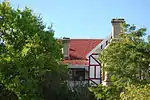 Type of site: House |
| 9/2/068/0004 | Old Drill Hall, Camp Street, Oudtshoorn | Oudtshoorn | Oudtshoorn | National Monument | Upload Photo | ||
| 9/2/068/0005 | OUDTSHOORN MUNICIPAL AREA, GENERAL | Oudtshoorn | Oudtshoorn | National Monument | Upload Photo | ||
| 9/2/068/0006 | Hazenjacht Farmstead, Oudtshoorn District | Type of site: Farmstead | Oudtshoorn | Provincial Heritage Site | 33°31′30″S 22°11′13″E / 33.525082°S 22.186890°E | Upload Photo | |
| 9/2/068/0007 | C P Nel Museum, Baron van Rheede Street, Oudtshoorn | This building, now a museum, dates from about 1909 and for some half a century served as a boys' school.
Designed in part by Bullock and Vixseboxe, the well known architects, it reflects the former's copiousness and the latter's Transvaal Republic influence.
Especially worthy of note is the facade, with its harmonious blending of styles.
|
Oudtshoorn | Oudtshoorn | Provincial Heritage Site | 33°35′31″S 22°12′07″E / 33.592069°S 22.201964°E | 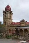 This building, now a museum, dates from about 1909 and for some half a century served as a boys' school.
Designed in part by Bullock and Vixseboxe, the well known architects, it reflects the former's copiousness and the latter's Transvaal Republic influence.
Especially worthy of note is the facade, with its harmonious blending of styles.
Type of site: Educational Previous use: School. Current use: Museum. |
| 9/2/068/0007/1 | Memorial, C P Nel Museum, Baron van Reede Street, Oudtshoorn | Oudtshoorn | Oudtshoorn | National Monument | 33°35′32″S 22°12′07″E / 33.592167°S 22.201915°E | Upload Photo | |
| 9/2/068/0008 | Welgeluk Ostrich Palace, Oudtshoorn District | Type of site: House Constructed during 1910, Welgeluk is regarded as one of the finest examples of the so-called "ostrich palaces" | Oudtshoorn | Provincial Heritage Site | 33°33′55″S 22°11′03″E / 33.565285°S 22.184143°E |  Type of site: House Constructed during 1910, Welgeluk is regarded as one of the finest examples of the so-called "ostrich palaces" | |
| 9/2/068/0009 | Greylands Ostrich Palace, Oudtshoorn District | Type of site: House Constructed during 1911, Greylands is regarded as one of the best examples of the so-called "ostrich palaces" | Oudtshoorn | Provincial Heritage Site | 33°33′42″S 22°13′11″E / 33.561709°S 22.219849°E | Upload Photo | |
| 9/2/068/0010 | Herrie's Stone, Meiringspoort, Oudtshoorn District | C.J. Langenhoven (1873–1932), Afrikaans writer, champion of the Afrikaans language and author of the South African National Anthem, chiselled the name of the well-known elephant Herrie, from his book Sonde met die Bure, on this rock in July 1929. | Oudtshoorn | Provincial Heritage Site | 33°32′49″S 22°15′20″E / 33.546975°S 22.255554°E |  C.J. Langenhoven (1873–1932), Afrikaans writer, champion of the Afrikaans language and author of the South African National Anthem, chiselled the name of the well-known elephant Herrie, from his book Sonde met die Bure, on this rock in July 1929. | |
| 9/2/068/0011 | Methodist Church Complex, 77 St. Saviour Street, Oudtshoorn | Oudtshoorn | Oudtshoorn | National Monument | 33°35′12″S 22°12′17″E / 33.586586°S 22.204671°E | Upload Photo | |
| 9/2/068/0012 | Magistrate's Residence, 77 Baron van Rheede Street, Oudtshoorn | Oudtshoorn | Oudtshoorn | 33°35′08″S 22°12′10″E / 33.585524°S 22.202697°E | Upload Photo | ||
| 9/2/068/0013 | Hartebeeshuisie, 6 Plein Street, Oudtshoorn | Oudtshoorn | Oudtshoorn | 33°36′22″S 22°12′45″E / 33.606222°S 22.212425°E | Upload Photo | ||
| 9/2/068/0014 | Montagu House, Baron van Rheede Street, Oudtshoorn | Oudtshoorn | Oudtshoorn | Upload Photo | |||
| 9/2/068/0015 | Gottland House, 72 Baron van Rheede Street, Oudtshoorn | Type of site: House
|
Oudtshoorn | Oudtshoorn | Provincial Heritage Site | 33°36′03″S 22°12′09″E / 33.600723°S 22.202635°E | 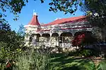 Type of site: House
Previous use: Residential. Current use: Old age home. Gottland House was built by Charles Bullock in 1902 in the opulent style prevailing during the ostrich feather boom. It is in the Victorian style with Art Nouveau elements. |
| 9/2/068/0016 | Dutch Reformed Church and Parsonage, Le Roux Street, De Rust | This cruciform church with its neo-Gothic characteristics, was designed by the architect George Wallis of Oudtshoorn.
The corner-stone was laid on 28 November 1900 by the Rev. J. A. Beyers and the building was officially inaugurated on 28 November 1902.
The impressive pulpit designed by another local architect, J. E. Vixseboxse, and installed in 1911, is also noteworthy.
The old hall, which was erected in 1904, was used as school from 1904 to 1913. At present it serves as church hall.
|
De Rust | Oudtshoorn | Provincial Heritage Site | 33°29′25″S 22°32′10″E / 33.490393°S 22.536062°E | 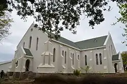 This cruciform church with its neo-Gothic characteristics, was designed by the architect George Wallis of Oudtshoorn.
The corner-stone was laid on 28 November 1900 by the Rev. J. A. Beyers and the building was officially inaugurated on 28 November 1902.
The impressive pulpit designed by another local architect, J. E. Vixseboxse, and installed in 1911, is also noteworthy.
The old hall, which was erected in 1904, was used as school from 1904 to 1913. At present it serves as church hall.
Type of site: Church and Parsonage |
| 9/2/068/0017 | Watermill, Voelgesang, De Rust, Oudtshoorn District | This double-storeyed water-mill with its enormous iron wheel dates from the 1890s.
|
OudtshoornTh | Provincial Heritage Site | 33°31′38″S 22°17′29″E / 33.527086°S 22.291260°E | Upload Photo | |
| 9/2/068/0018 | Dutch Reformed Church, Volmoed, Oudtshoorn District | Type of site: Church.
|
Oudtshoorn | Provincial Heritage Site | 33°34′12″S 22°13′21″E / 33.569862°S 22.222595°E | Upload Photo | |
| 9/2/068/0019 | Oakdene, 99 Baron van Rheede Street, Oudtshoorn | Type of site: House.
|
Oudtshoorn | Oudtshoorn | Provincial Heritage Site | 33°34′42″S 22°12′20″E / 33.578305°S 22.205440°E |  Type of site: House.
Current use: House. |
| 9/2/068/0020 | 146 High Street, Oudtshoorn | This richly ornamented Victorian, house is one of the so-called "ostrich palaces" and was designed by the well known architect Charles Bullock.
It was erected during 1909/10 for J. H. J. le Roux of the farm Baakenskraal at a stage when the ostrich feather industry was its peak. |
Oudtshoorn | Oudtshoorn | Provincial Heritage Site | 33°34′46″S 22°12′12″E / 33.579507°S 22.203197°E |  This richly ornamented Victorian, house is one of the so-called "ostrich palaces" and was designed by the well known architect Charles Bullock.
It was erected during 1909/10 for J. H. J. le Roux of the farm Baakenskraal at a stage when the ostrich feather industry was its peak. |
| 9/2/068/0021 | Mimosa Lodge, 85 Baron van Rheede Street, Oudtshoorn | Type of site: House
|
Oudtshoorn | Oudtshoorn | Provincial Heritage Site | 33°34′43″S 22°12′20″E / 33.578745°S 22.205472°E |  Type of site: House
Current use: House. |
| 9/2/068/0022 | St. Jude's Church complex, Oudtshoorn | Oudtshoorn | Oudtshoorn | National Monument |  | ||
| 9/2/068/0022/001 | St Jude's Church, Baron van Rheede Street, Oudtshoorn | The historical St Jude's Church was originally designed by Sophia Gray, wife of Bishop Robert Gray and completed in 1863.
The building is closely linked with the history of Oudtshoorn and of the Anglican Church in South Africa.
|
Oudtshoorn | Oudtshoorn | Provincial Heritage Site | 33°34′43″S 22°12′20″E / 33.578674°S 22.205472°E | 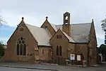 The historical St Jude's Church was originally designed by Sophia Gray, wife of Bishop Robert Gray and completed in 1863.
The building is closely linked with the history of Oudtshoorn and of the Anglican Church in South Africa.
Type of site: Church Current use: Church : Anglican. |
| 9/2/068/0023 | Dutch Reformed Church, High Street, Oudtshoorn | The foundation stone of this church was laid on 15 January 1861, but because of financial and other problems it could only be consecrated on 7 June 1879.
George Wallace was responsible for the building plans.
|
Oudtshoorn | Oudtshoorn | Provincial Heritage Site | 33°36′27″S 22°02′38″E / 33.607428°S 22.043965°E | 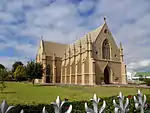 The foundation stone of this church was laid on 15 January 1861, but because of financial and other problems it could only be consecrated on 7 June 1879.
George Wallace was responsible for the building plans.
Type of site: Church. Current use: Church : Dutch Reformed. |
| 9/2/068/0024 | Pinehurst, Oudtshoorn | Pinehurst, one of the best known of the so called "ostrich palaces" stands on the western side of the Grobbelaar's River almost in the centre of Oudtshoorn.
It is now a part of the men's hostel of the Teachers' Training College. |
Oudtshoorn | Oudtshoorn | Provincial Heritage Site | 33°36′02″S 22°12′07″E / 33.600481°S 22.202039°E | Upload Photo |
| 9/2/068/0025 | Suspension Bridge, Church Street, Oudtshoorn | At the same time as the coastal area from Swellendam to George was being settled, the Little Karoo and its extension beyond the Langeberg and Outeniqua Mountains, the Langkloof, were being explored and occupied by cattle farmers.
The break-through to this area occurred successively through the Cogman’s Kloof at Montagu, then through the Attaqua Kloof (or Robinson's Pass) opposite Mossel Bay, and the Cradock Kloof which is traversed by the Outeniqua Pass today.
|
Oudtshoorn | Oudtshoorn | Provincial Heritage Site | 33°35′17″S 22°12′04″E / 33.588127°S 22.200980°E | 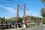 At the same time as the coastal area from Swellendam to George was being settled, the Little Karoo and its extension beyond the Langeberg and Outeniqua Mountains, the Langkloof, were being explored and occupied by cattle farmers.
The break-through to this area occurred successively through the Cogman’s Kloof at Montagu, then through the Attaqua Kloof (or Robinson's Pass) opposite Mossel Bay, and the Cradock Kloof which is traversed by the Outeniqua Pass today.
Type of site: Bridge Current use: Bridge. An attractive suspension bridge built in 1913-1914 and an interesting feature in Oudtshoorn. |
| 9/2/068/0026 | Schoeman House, Rietvallei, Oudtshoorn District | Oudtshoorn | Provincial Heritage Site | 33°31′58″S 22°32′28″E / 33.532688°S 22.541081°E | Upload Photo | ||
| 9/2/068/0027 | Vredelus homestead, De Rust, Oudtshoorn District | Oudtshoorn | Provincial Heritage Site | 33°29′24″S 22°31′46″E / 33.489981°S 22.529402°E | Upload Photo | ||
| 9/2/068/0028 | Mons Ruber Estate Wine tasting room, Rietvlei, Oudtshoorn District | Oudtshoorn | Provincial Heritage Site | 33°30′46″S 22°29′48″E / 33.512862°S 22.496696°E | Upload Photo | ||
| 9/2/068/0029 | Municipal Cemetery, Oudtshoorn | Oudtshoorn | Oudtshoorn | National Monument | 33°35′19″S 22°13′13″E / 33.588577°S 22.220386°E | Upload Photo | |
| 9/2/068/0030 | Oude Muragie, Oudtshoorn District | Oudtshoorn | Oudtshoorn | 33°27′16″S 22°26′16″E / 33.454526°S 22.437807°E | Upload Photo | ||
| 9/2/068/0031 | Saffraanrivier, Oudtshoorn District | Oudtshoorn | Oudtshoorn | 33°44′11″S 22°02′13″E / 33.736283°S 22.037039°E | Upload Photo | ||
| 9/2/068/0032 | Dutch Reformed Church Parsonage, High Street, Oudtshoorn | This parsonage is a double-storeyed building which was constructed in the Victorian style and completed in 1882.
|
Oudtshoorn | Oudtshoorn | Provincial Heritage Site | 33°36′25″S 22°02′40″E / 33.607021°S 22.044456°E | Upload Photo |
| 9/2/068/0033 | Queen's Hotel, Baron van Rheede Street, Oudtshoorn | Oudtshoorn | Oudtshoorn | National Monument | 33°35′29″S 22°12′09″E / 33.591503°S 22.202567°E | Upload Photo | |
| 9/2/068/0034 | Boomplaas Cave, Cango Valley, Oudtshoorn District | Oudtshoorn | Oudtshoorn | Upload Photo | |||
| 9/2/068/0035 | Nooitgedacht Fossil Site, Cango Valley, Oudtshoorn District | Oudtshoorn | Oudtshoorn | Upload Photo | |||
| 9/2/068/0036 | OUDTSHOORN MAGISTERIAL DISTRICT, GENERAL | Oudtshoorn | Oudtshoorn | Upload Photo | |||
| 9/2/072/0001 | Kersefontein, Piketberg District | Piketberg | Piketberg | 32°54′14″S 18°19′56″E / 32.903913°S 18.332268°E |  | ||
| 9/2/072/0001-001 | Farmstead, Kersefontein, Piketberg District | Kersefontein came into the possession of the Melck family in 1770.
Successive generations built and maintained the gracious homestead and outbuildings.
|
Piketberg | Provincial Heritage Site | 32°54′05″S 18°46′02″E / 32.901483°S 18.767256°E | Kersefontein came into the possession of the Melck family in 1770.
Successive generations built and maintained the gracious homestead and outbuildings.
Type of site: Farmstead | |
| 9/2/072/0001-002 | Outbuildings, Kersefontein, Piketberg District | Type of site: Outbuilding | Piketberg | Provincial Heritage Site | 32°54′00″S 18°45′58″E / 32.900136°S 18.766172°E | 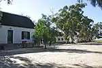 Type of site: Outbuilding | |
| 9/2/072/0002 | Northern terminal of Maclear's Arc of Meridian, Klipfontein, Piketberg District | Type of site: Survey beacon Drive out of Auroa on the road to Redelinghuys.
The site is situated on the left side of the road about 2 kilometres from the town. There is a cairn marking the site. |
Piketberg | Provincial Heritage Site | 32°53′59″S 18°46′00″E / 32.899732°S 18.766708°E | Type of site: Survey beacon Drive out of Auroa on the road to Redelinghuys.
The site is situated on the left side of the road about 2 kilometres from the town.
There is a cairn marking the site. | |
| 9/2/072/0003 | Banghoek Farm, Piketberg District | Piketberg | Piketberg | National Monument | Upload Photo | ||
| 9/2/072/0004 | Goedverwacht/Wittewater Mission Complex, Piketberg District | Type of site: Mission Station | Piketberg | Provincial Heritage Site | 33°13′40″S 21°51′25″E / 33.227792°S 21.856859°E | 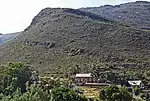 Type of site: Mission Station | |
| 9/2/072/0005 | Verlorenvlei, Elands Bay, Piketberg District | Elands Bay | Piketberg | National Monument | 32°20′01″S 18°25′06″E / 32.333598°S 18.418430°E | Upload Photo | |
| 9/2/072/0006 | Fisherman's Cottage, Alana Avenue, Velddrif, Piketberg District | Velddrif | Piketberg | Upload Photo | |||
| 9/2/072/0007 | Old Municipal Cemetery, Piketberg | Piketberg | Piketberg | Upload Photo | |||
| 9/2/072/0008 | Fisherman's Cottage, 71 Voortrekker Road, Velddrif, Piketberg | Velddrif | Piketberg | 32°54′50″S 18°45′19″E / 32.913806°S 18.755274°E | Upload Photo | ||
| 9/2/072/0009 | PIKETBERG MUNICIPAL AREA, GENERAL | Piketberg | Piketberg | Upload Photo | |||
| 9/2/072/0010 | Dutch Reformed Church, Church Street, Piketberg | Very fine Cape Gothic dressed stone church with white plaster detailing.
Decoration is unusually 'spiky'.
This church in the Neo-Gothic style, was designed by Carl Otto Hager.
The foundation stone was laid on 12 August 1880.
The building was completed early in 1882 and was officially inaugurated on 28 April.
|
Piketberg | Piketberg | Provincial Heritage Site | 32°54′09″S 18°45′55″E / 32.902480°S 18.765270°E | 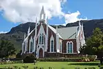 Very fine Cape Gothic dressed stone church with white plaster detailing.
Decoration is unusually 'spiky'.
This church in the Neo-Gothic style, was designed by Carl Otto Hager.
The foundation stone was laid on 12 August 1880.
The building was completed early in 1882 and was officially inaugurated on 28 April.
Type of site: Church Current use: Church : Dutch Reformed. |
| 9/2/072/0011 | Rock painting of galleon, Heidedal Farm, Porterville | Porterville | Piketberg | National Monument | Upload Photo | ||
| 9/2/072/0012 | Woburn Lodge, 12 Waterkant Street, Piketberg | Type of site: House
|
Piketberg | Piketberg | Provincial Heritage Site | 32°54′02″S 18°45′18″E / 32.900486°S 18.755101°E | Upload Photo |
| 9/2/072/0013 | Archaeological excavations, Piketberg | Piketberg | Piketberg | National Monument | Upload Photo | ||
| 9/2/072/0014 | Deze Hoek, Piketberg District | Piketberg | Piketberg | 32°51′48″S 18°44′53″E / 32.863348°S 18.748154°E | Upload Photo | ||
| 9/2/072/0014/001 | Watermill, Deze Hoek, Piketberg District | Small mill structure.
Stone with mud plaster, under thatch.
Overshot wooden wheel.
All workings present.
This watermill was erected during the years 1863-1864 by Jacob Johannes Eksteen, the then owner of Deze Hoek.
The impressive overshot mill wheel was manufactured during the same period by Jan Dommisse.
|
Piketberg | Provincial Heritage Site | 32°51′50″S 18°44′55″E / 32.8638888888°S 18.7486111111°E | Upload Photo | |
| 9/2/072/0015 | St Helenafontein, Piketberg District | The original St Helenafontein farmhouse was presumably erected in 1835 by Pierre Rocher.
In the 1880s a second storey replaced the pitched roof and the building was converted to the Georgian style.
|
Piketberg | Provincial Heritage Site | 32°36′S 18°21′E / 32.6°S 18.35°E | Upload Photo | |
| 9/2/072/0016 | Koopmanskraal, Piketberg District | The Koopmanskraal homestead, together with the nearby outbuilding in which a horse-mill is located, forms a unique thatched complex that dates from the 19th century.
The ground plan of the homestead, which is in the shape of a rough crucifix, is more common in ecclesiastical than in domestic architecture. The building was accidentally destroyed by a fire in 1993.[3]
|
Piketberg | Provincial Heritage Site | 32°32′00″S 18°39′40″E / 32.5333333333°S 18.6611111111°E | Upload Photo | |
| 9/2/072/0017 | Museum, Porterville | Current use: Museum. | Porterville | Piketberg | Provincial Heritage Site | 33°00′46″S 18°59′41″E / 33.012656°S 18.994647°E | 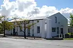 Current use: Museum. |
| 9/2/072/0018 | Fishhouse Museum, Velddrif, Piketberg District | Piketberg | Piketberg | National Monument | Upload Photo | ||
| 9/2/072/0019 | 16-18 Main Street, Piketberg | Piketberg | Piketberg | 32°54′24″S 18°45′20″E / 32.906754°S 18.755519°E | Upload Photo | ||
| 9/2/072/0020 | Klaarefontein, Piketberg District | Piketberg | Piketberg |  | |||
| 9/2/072/0021 | Dunn's Castle, Piketberg District | Piketberg | Piketberg | 32°54′50″S 18°45′27″E / 32.913929°S 18.757478°E | Upload Photo | ||
| 9/2/072/0022 | VELDDRIF MUNICIPAL AREA, GENERAL | Piketberg | Piketberg | Pending Declaration | Upload Photo | ||
| 9/2/072/0023 | PIKETBERG MAGISTERIAL DISTRICT, GENERAL | Velddrif | Piketberg | Upload Photo | |||
| 9/2/072/0024 | Doornboom Farmstead, Piketberg District | Piketberg | Piketberg | Upload Photo | |||
| 9/2/072/0025 | DWARSKERSBOS GENERAL, PIKETBERG DISTRICT | Piketberg | Piketberg | Upload Photo | |||
| 9/2/072/0026 | PORTERVILLE MUNICIPAL AREA, GENERAL | Porterville | Picketberg | Upload Photo | |||
| 9/2/076/0001 | 2 Church Street, Prince Albert | Prince Albert | Prince Albert | 33°13′57″S 22°01′53″E / 33.232567°S 22.031317°E | Upload Photo | ||
| 9/2/076/0002 | Homestead, Baviaanskloof, Prince Albert District | This farmhouse has fine gables, including a front gable which bears the date 1837.
The house itself, together with its stone step in front, is a good example of Boland farm culture in the Karoo.
|
Prince Albert | Provincial Heritage Site | 33°14′13″S 21°50′55″E / 33.236861°S 21.848567°E | Upload Photo | |
| 9/2/076/0004 | Gamkaskloof, Prince Albert District | Type of site: Settlement | Prince Albert | Provincial Heritage Site | 33°14′46″S 22°02′39″E / 33.246230°S 22.044140°E | Upload Photo | |
| 9/2/076/0005 | Historical Graveyard, John Nutt se Draai, Prince Albert | Prince Albert | Prince Albert | Pending Declaration | Upload Photo | ||
| 9/2/076/0006 | Erf 193, Swartberg Hotel, Church Street, Prince Albert | Type of site: Hotel
|
Prince Albert | Prince Albert | Provincial Heritage Site | 33°13′23″S 22°01′46″E / 33.222947°S 22.029467°E | 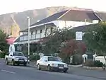 Type of site: Hotel
Current use: Hotel. |
| 9/2/076/0007 | Scholtzkloof, Prince Albert District | Prince Albert | Prince Albert | National Monument | Upload Photo | ||
| 9/2/076/0008 | Albert's Mill, Christina de Wit Street, Prince Albert | Prince Albert lies at the foot of the Swartberg Pass, 72 km from Oudtshoorn and 45 km from the national road between Laingsburg and Beaufort West.
It is an interesting old town, with its whitewashed gabled houses which strongly reflect the characteristic architecture of the Cape.
|
Prince Albert | Prince Albert | Provincial Heritage Site | 33°12′40″S 22°01′17″E / 33.211196°S 22.021491°E |  Prince Albert lies at the foot of the Swartberg Pass, 72 km from Oudtshoorn and 45 km from the national road between Laingsburg and Beaufort West.
It is an interesting old town, with its whitewashed gabled houses which strongly reflect the characteristic architecture of the Cape.
Type of site: Mill. Previous use: Mill. This old watermill was built by HJ Botes in 1850 and is still in working order. Situated at the foot of the Swart Berg Pass it is an outstanding feature on this popular tourist route. |
| 9/2/076/0009 | Witbergie Rockshelter, Tierberg, Prince Albert District | Prince Albert | Prince Albert | National Monument | 33°08′18″S 22°15′08″E / 33.138340°S 22.252227°E | Upload Photo | |
| 9/2/076/0010 | Farm Klein Sleutelfontein (Part of Vrolikheid), Prince Albert District | Prince Albert | Prince Albert | Upload Photo | |||
| 9/2/076/0011 | PRINCE ALBERT MUNICIPAL AREA, GENERAL | Prince Albert | Prince Albert | Upload Photo | |||
| 9/2/076/0012 | Krige House, 24 Church Street, Prince Albert | Prince Albert | Prince Albert | 33°13′34″S 22°01′49″E / 33.226171°S 22.030323°E | Upload Photo | ||
| 9/2/076/0013 | Swartberg Pass, Prince Albert District | Prince Albert | Prince Albert | Pending Declaration | 33°21′08″S 22°02′47″E / 33.352108°S 22.046461°E | Upload Photo | |
| 9/2/076/0014 | Old Mission Church Parsonage, 5 Church Street, Prince Albert | This cottage, with its typical Prince Albert front sable, was erected in 1858 by Helmuth Luttig.
It was occupied by the Luttig family until 1907 when the property was purchased by the Dutch Reformed Church and converted into a mission parsonage.
|
Prince Albert | Prince Albert | Provincial Heritage Site | 33°13′34″S 22°01′49″E / 33.226175°S 22.030307°E | Upload Photo |
| 9/2/076/0015 | Homestead, Vrolikheid, Prince Albert District | Type of site: Farmstead
|
Prince Albert | Provincial Heritage Site | 33°13′40″S 21°51′25″E / 33.227792°S 21.856859°E | Upload Photo | |
| 9/2/076/0016 | Dutch Reformed Church, Zeekoegat, Prince Albert District | This church was erected in 1906 free of charge by Mr F. Oosthuizen of Zwartkraal, who was also the owner of Zeekoegat.
The building was inaugurated on 23 February 1907 by Rev. D. Wilcocks of Prince Albert and Rev. Albertyn of Willowmore. |
Prince Albert | Provincial Heritage Site | 33°13′40″S 21°51′25″E / 33.227792°S 21.856859°E | Upload Photo | |
| 9/2/076/0017 | 57 Church Street, Prince Albert | Type of site: House.
|
Prince Albert | Prince Albert | Provincial Heritage Site | 33°13′33″S 22°01′49″E / 33.225951°S 22.030294°E | 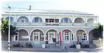 Type of site: House.
Current use: Residential. |
| 9/2/076/0018 | Bona Vista, 7 Parsonage Street cnr de Beer Street, Prince Albert | Type of site: House.
|
Prince Albert | Prince Albert | Provincial Heritage Site | 33°13′40″S 22°01′50″E / 33.227780°S 22.030672°E | Upload Photo |
| 9/2/076/0019 | Dutch Reformed Church and Hall, Prince Albert | Type of site: Church | Prince Albert | Prince Albert | Provincial Heritage Site | 33°13′31″S 22°01′48″E / 33.225278°S 22.030000°E | 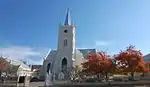 Type of site: Church |
| 9/2/076/0019-001 | Dutch Reformed Church, Church Street, Prince Albert | Type of site: Church | Prince Albert | Prince Albert | Provincial Heritage Site | 33°13′15″S 22°01′45″E / 33.220894°S 22.029029°E | 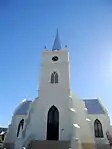 Type of site: Church |
| 9/2/076/0019-002 | Dutch Reformed Church Hall, Market Street cnr Parsonage Street, Prince Albert | Type of site: Church Hall | Prince Albert | Prince Albert | Provincial Heritage Site | 33°13′41″S 22°01′47″E / 33.227964°S 22.029754°E | Type of site: Church Hall |
| 9/2/076/0020 | Dutch Reformed Church Parsonage, 2 Parsonage Street, Prince Albert | Type of site: House.
|
Prince Albert | Prince Albert | Provincial Heritage Site | 33°13′38″S 22°01′45″E / 33.227135°S 22.029092°E | 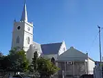 Type of site: House.
Current use: Parsonage. |
| 9/2/076/0021 | 15 Church Street, Prince Albert | Type of site: House.
|
Prince Albert | Prince Albert | Provincial Heritage Site | 33°13′34″S 22°01′49″E / 33.226175°S 22.030307°E |  Type of site: House.
Current use: Residential. |
| 9/2/076/0022 | 20 Church Street, cnr Jan Louw Street, Prince Albert | Type of site: House.
|
Prince Albert | Prince Albert | Provincial Heritage Site | 33°13′48″S 22°01′53″E / 33.230059°S 22.031398°E | Upload Photo |
| 9/2/076/0023 | Military Graves, Leeu-Gamka, Prince Albert District | Prince Albert | Prince Albert | National Monument | Upload Photo | ||
| 9/2/076/0024 | Conservation area, Prince Albert | Prince Albert | Prince Albert | Upload Photo | |||
| 9/2/076/0025 | Anglican Church Cemetery, Klaarstroom, Prince Albert District | Prince Albert | Prince Albert | Upload Photo | |||
| 9/2/076/0026 | Grave of Private W Calver, Goeiemoed, Prince Albert District | Prince Albert | Prince Albert | Upload Photo | |||
| 9/2/076/0027 | Erf 1513, Church Street, Prince Albert | Prince Albert | Prince Albert | Upload Photo | |||
| 9/2/076/0028 | Klaarstroom General, Prince Albert District | Prince Albert | Prince Albert | Upload Photo | |||
| 9/2/076/0029 | 26 Church Street cnr Parsonage Street, Prince Albert | Prince Albert | Prince Albert | Provincial Heritage Site | 33°13′42″S 22°01′51″E / 33.228195°S 22.030773°E |  | |
| 9/2/076/0030 | St John the Baptist Anglican Church, Bank Street, Prince Albert | Type of site: Church | Prince Albert | Prince Albert | Provincial Heritage Site | 33°13′35″S 22°01′46″E / 33.226301°S 22.029324°E | 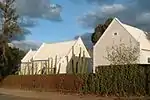 Type of site: Church |
| 9/2/076/0031 | Dennehof, Christina de Wit Street, Prince Albert | Prince Albert | Prince Albert | Provincial Heritage Site | 33°12′39″S 22°01′17″E / 33.210888°S 22.021463°E | Upload Photo | |
| 9/2/076/0032 | PRINCE ALBERT MAGISTERIAL DISTRICT, GENERAL | Prince Albert | Prince Albert | Upload Photo | |||
| 9/2/076/0033 | Grave of Lt. Klue, Farm Riemhoogte, Prince Albert District | Prince Albert | Prince Albert | Upload Photo | |||
| 9/2/096/0001 | UNIONDALE MAGISTERIAL DISTRICT, GENERAL | Uniondale | Uniondale | National Monument | Upload Photo | ||
| 9/2/096/0002 | UNIONDALE MUNICIPAL AREA, GENERAL | Uniondale | Uniondale | Upload Photo | |||
| 9/2/096/0003 | HAARLEM, UNIONDALE DISTRICT, GENERAL | Uniondale | Uniondale | Upload Photo | |||
| 9/2/096/0004 | Dutch Reformed Church, Kerk Street, Uniondale | Uniondale | Uniondale | 33°39′29″S 23°07′37″E / 33.658158°S 23.126872°E | Upload Photo | ||
| 9/2/096/0005 | Old Congregational Church complex, Voortrekker Street, Uniondale | Type of site: Church Complex.
|
Uniondale | Uniondale | Provincial Heritage Site | 33°39′08″S 23°08′05″E / 33.652140°S 23.134620°E | 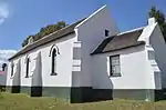 Type of site: Church Complex.
Current use: Disused. |
| 9/2/096/0006 | Evangelical Lutheran Church, Haarlem | The historic Lutheran Mission Church, built in the shape of a Greek crucifix, was erected at Haarlem between 1877and 1880 and is one of the few churches in South Africa built in this traditional style.
|
Haarlem | Uniondale | Provincial Heritage Site | 33°44′01″S 23°20′21″E / 33.733584°S 23.339217°E | 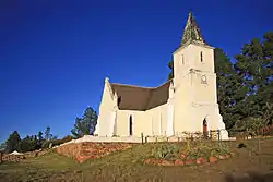 The historic Lutheran Mission Church, built in the shape of a Greek crucifix, was erected at Haarlem between 1877and 1880 and is one of the few churches in South Africa built in this traditional style.
Type of site: Church Current use: Religious. |
| 9/2/096/0007 | Old Residency, 6 Victoria Street, Uniondale | The residency is typical of the late nineteenth century house architecture of Uniondale.
This house, of which the floors, loft, crib and stable are of yellow-wood, undoubtedly contributes to the historic character of this town.
|
Uniondale | Uniondale | Provincial Heritage Site | 33°39′19″S 23°07′34″E / 33.655162°S 23.126241°E | Upload Photo |
| 9/2/096/0008 | Old Dutch Reformed Church, Voortrekker Street, Uniondale | This church was erected in 1862, the style being predominantly neo-Gothic.
It is closely connected with the history of the town.
|
Uniondale | Uniondale | Provincial Heritage Site | 33°39′08″S 23°08′05″E / 33.652140°S 23.134620°E | 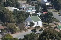 This church was erected in 1862, the style being predominantly neo-Gothic.
It is closely connected with the history of the town.
Type of site: Church Previous use: Church. Current use: Disused. |
| 9/2/096/0009 | Old Watermills, Haarlem | Type of site: Water Mill.
|
Haarlem | Uniondale | Provisional Protection | 33°44′45″S 23°20′26″E / 33.745932°S 23.340676°E | Upload Photo |
| 9/2/096/0010 | Anglican Cemetery, Uniondale | Uniondale | Uniondale | Provincial Monument | 33°39′22″S 23°07′42″E / 33.656099°S 23.128399°E | Upload Photo | |
| 9/2/096/0011 | Prince Alfred's Pass, Uniondale District | Uniondale | Uniondale | 33°50′00″S 23°10′00″E / 33.833332°S 23.166664°E | Upload Photo | ||
| 9/2/096/0012 | Old Synagogue, Victoria Street, Uniondale | Uniondale | Uniondale | Pending Declaration | 33°39′22″S 23°07′30″E / 33.656071°S 23.124914°E | Upload Photo | |
| 9/2/096/0013 | Police Station and Magistrate's Court, 51 Voortrekker Street, Uniondale | Uniondale | Uniondale | 33°39′26″S 23°07′33″E / 33.657213°S 23.125768°E | Upload Photo | ||
| 9/2/096/0014 | Standard Bank, 31 Voortrekker Street, Uniondale | Uniondale | Uniondale | 33°39′21″S 23°07′44″E / 33.655698°S 23.128845°E | Upload Photo | ||
| 9/2/096/0015 | All Saints Church 33 Voortrekker Street, Uniondale | Type of site: Church.
|
Uniondale | Uniondale | Provincial Heritage Site | 33°39′22″S 23°07′42″E / 33.656085°S 23.128385°E | 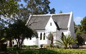 Type of site: Church.
Current use: Church : Anglican. |
| 9/2/096/0016 | 35 Voortrekker Street, Uniondale | Uniondale | Uniondale | 33°39′25″S 23°07′34″E / 33.656880°S 23.125998°E | Upload Photo | ||
| 9/2/096/0017 | 26 Victoria Street, Uniondale | Current use: Office. | Uniondale | Uniondale | Provincial Heritage Site | 33°39′19″S 23°07′34″E / 33.655162°S 23.126241°E | 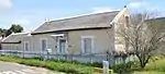 Current use: Office. |
| 9/2/096/0018 | 28 Victoria Street, Uniondale | Type of site: House.
|
Uniondale | Uniondale | Provincial Heritage Site | 33°39′19″S 23°07′34″E / 33.655162°S 23.126241°E | 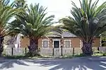 Type of site: House.
Current use: House. |
| 9/2/096/0019 | 14 Victoria Street, Uniondale | Uniondale | Uniondale | National Monument | 33°39′20″S 23°07′33″E / 33.655425°S 23.125716°E | Upload Photo | |
| 9/2/096/0020 | 2 Victoria Street, Uniondale | Uniondale | Uniondale | 33°39′14″S 23°07′43″E / 33.653927°S 23.128690°E | Upload Photo | ||
| 9/2/096/0021 | 18 Victoria Street, Uniondale | Uniondale | Uniondale | 33°39′16″S 23°07′38″E / 33.654577°S 23.127144°E | Upload Photo | ||
| 9/2/096/0022 | Anglo-Boer War blockhouse, Uniondale | This historic fort was erected during the Anglo-Boer War by the British military authorities and the so-called Town Guards for the defence of Uniondale.
Four similar structures were built at the time at Uniondale.
These fortifications differed considerably
|
Uniondale | Uniondale | Provincial Heritage Site | 33°38′55″S 23°08′18″E / 33.648626°S 23.138200°E |  This historic fort was erected during the Anglo-Boer War by the British military authorities and the so-called Town Guards for the defence of Uniondale.
Four similar structures were built at the time at Uniondale.
These fortifications differed considerably
Type of site: Blockhouse Previous use: Fortification. |
| 9/2/096/0023 | Watermill, Uniondale | The structure consists of a double-storeyed building and the mill's wooden wheel is of the undershot type.
This water mill was built in 1854 by J. A.van Rooyen and is the only remaining water mill in Uniondale.
|
Uniondale | Uniondale | Provincial Heritage Site | 33°38′55″S 23°08′18″E / 33.648626°S 23.138200°E | 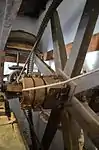 The structure consists of a double-storeyed building and the mill's wooden wheel is of the undershot type.
This water mill was built in 1854 by J. A.van Rooyen and is the only remaining water mill in Uniondale.
Type of site: Water Mill Previous use: Mill. Current use: Museum. |
| 9/2/096/0024 | Anhalt-Schmidt Parsonage, Burg Street, Haarlem | Haarlem | Uniondale | National Monument | Upload Photo | ||
| 9/2/097/0001 | Rock Paintings, Wiedou, Vanrhynsdorp District | Vanrhynsdorp | Vanrhynsdorp | Upload Photo | |||
| 9/2/097/0002 | Vondeling, Vanrhynsdorp District | Vanrhynsdorp | Vanrhynsdorp | Upload Photo | |||
| 9/2/097/0003 | Heerenlogement Cave, Olifantsrivier, Van Rhynsdorp District | see 9/2/102/0002 & 9/2/022/0037 Heerenlogement | Provincial Heritage Site | 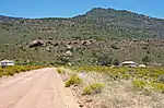 see 9/2/102/0002 & 9/2/022/0037 Heerenlogement | |||
| 9/2/097/0004 | 44 Voortrekker Street, Vanrhynsdorp | Vanrhynsdorp | Vanrhynsdorp | 31°36′34″S 18°44′10″E / 31.609420°S 18.736125°E | Upload Photo | ||
| 9/2/097/0005 | VANRHYNSDORP MUNICIPAL AREA, GENERAL | Vanrhynsdorp | Vanrhynsdorp | Upload Photo | |||
| 9/2/097/0006 | St Theresa Roman Catholic Church, Vanrhynsdorp | Vanrhynsdorp | Vanrhynsdorp | Upload Photo | |||
| 9/2/097/0007 | Municipal cemetery, Vanrhynsdorp | Vanrhynsdorp | Vanrhynsdorp | Upload Photo | |||
| 9/2/097/0008 | VANRHYNSDORP MAGISTERIAL DISTRICT, GENERAL | Vanrhynsdorp | Vanrhynsdorp | Upload Photo | |||
| 9/2/097/0009 | Rock Paintings, Vanrhynsdorp District | Vanrhynsdorp | Vanrhynsdorp | Upload Photo | |||
| 9/2/097/0010 | Van Rhyn Museum, Van Riebeeck Street, Vanrhynsdorp | Vanrhynsdorp | Vanrhynsdorp | 31°36′33″S 18°44′09″E / 31.609100°S 18.735838°E | Upload Photo | ||
| 9/2/097/0011 | Anglo-Boer War Fort, Aties 308, Vanrhynsdorp District | Type of site: Military | Vanrhynsdorp | Provincial Heritage Site | 31°40′31″S 18°41′14″E / 31.675329°S 18.687143°E | Upload Photo | |
| 9/2/097/0012 | Grave of Lemuel Colyn, Farm Onder-Aties, Vanrhynsdorp Dist | Vanrhynsdorp | Vanrhynsdorp | Upload Photo | |||
| 9/2/097/0013 | Windhoek Farm, Klawer, Vanrhynsdorp Dist | Klawer | Vanrhynsdorp | Upload Photo | |||
| 9/2/101/0001 | VREDENBURG MUNICIPAL AREA, GENERAL | Vredenburg | Vredenburg | Upload Photo | |||
| 9/2/101/0002 | Grave of gunner Jeffries, Abandoned Cemetery, Saldanha, Vredenburg | Vredenburg | Vredenburg | Upload Photo | |||
| 9/2/101/0003 | ST HELENA BAY, GENERAL | Vredenburg | Vredenburg | Upload Photo | |||
| 9/2/101/0004 | Hoedjiespunt, Saldanha, Vredenburg District | Vredenburg | Vredenburg | Upload Photo | |||
| 9/2/101/0005 | Besterskraal farm, Varswater Bay, Vredenburg District | Vredenburg | Vredenburg | National Monument | Upload Photo | ||
| 9/2/101/0006 | VREDENBURG MAGISTERIAL DISTRICT, GENERAL | Vredenburg | Vredenburg | Upload Photo | |||
| 9/2/101/0006/1 | Coastal Archaeology, Vredenburg Magisterial District | Vredenburg | Vredenburg | Upload Photo | |||
| 9/2/101/0006/2 | Varswaterbaai, Vredenburg District | Vredenburg | Vredenburg | Upload Photo | |||
| 9/2/101/0007 | Fishermen's cottages, Saldanha | These oval-shaped cottages were built by George Goode Busch in 1918 and are the only remaining fishermen's cottages of this type in the vicinity of Saldanha. | Saldanha | Vredenburg | Provincial Heritage Site | 33°00′18″S 17°56′39″E / 33.005000°S 17.944170°E | 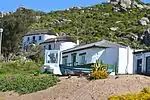 These oval-shaped cottages were built by George Goode Busch in 1918 and are the only remaining fishermen's cottages of this type in the vicinity of Saldanha. |
| 9/2/101/0008 | Die Krans rock shelter, Vredenburg District | Vredenburg | Vredenburg | National Monument | Upload Photo | ||
| 9/2/101/0010 | Grave of Lt Simeon W Cummings, Kliprug, Vredenbrug District | Vredenburg | Vredenburg |  | |||
| 9/2/101/0011 | Varswaterbaai, Vredenburg | Vredenburg | Vredenburg | Upload Photo | |||
| 9/2/101/0012 | Kasteelberg, Vredenburg District | Vredenburg | Vredenburg | 33°22′15″S 18°51′28″E / 33.370698°S 18.857704°E | Upload Photo | ||
| 9/2/101/0013 | PATERNOSTER LOCAL AREA, GENERAL | Vredenburg | Vredenburg | Upload Photo | |||
| 9/2/101/0014 | SALDANHA MUNICIPAL AREA, GENERAL | Vredenburg | Vredenburg | Upload Photo | |||
| 9/2/101/0015 | Alpha Saldanha Cement Project, Saldanha | Saldahna | Vredenburg | Upload Photo | |||
| 9/2/101/0016 | Cape Columbine Lighthouse, Castle rock, Paternoster, Vredenburg | Vredenburg | Vredenburg | Upload Photo | |||
| 9/2/102/0001 | VREDENDAL MAGISTERIAL DISTRICT, GENERAL | Vredendal | Vredendal | Upload Photo | |||
| 9/2/102/0002 | Heerenlogement Cave, Graafwater, Vredendal Dist (See 9/2/097/0003; 9/2/022/0037) | Vredendal | Vredendal | 31°57′42″S 18°32′59″E / 31.961755°S 18.549689°E | Upload Photo | ||
| 9/2/102/0003 | Bergh Fountain, Klipfontein, Vredendal District | On a rock in this area the name of O Slotsbo, IT Rhenius and O Bergh are engraved.
On 30 October 1682, a party under the leadership of Oloff Bergh left the Castle to investigate the area from which the Namakwas brought samples of copper-ore the previous year. Bergh engraved his name and 1682 on the rock.
|
Vredendal | Provincial Heritage Site | 32°00′20″S 18°31′00″E / 32.0055555555°S 18.5166666666°E | Upload Photo | |
| 9/2/102/0004 | Anglo-Boer War blockhouses, Klipfontein, Vredendal District | Vredendal | Vredendal | Upload Photo | |||
| 9/2/102/0005 | Melkboomsdrift 184, Vredendal District | Dwelling & agricultural building.
|
Vredendal | Register | 33°13′40″S 21°51′25″E / 33.227792°S 21.856859°E | Upload Photo | |
| 9/2/102/0006 | Jerusalom, Farm Hollebaks, Vredendal District | Vredendal | Vredendal | Upload Photo | |||
| 9/2/102/0007 | Brand se baai, Vredendal District | Vredendal | Vredendal | Upload Photo | |||
| 9/2/102/0008 | Van Zyl House, Vredendal | Vredendal | Vredendal | Upload Photo | |||
| 9/2/102/0009 | Vlermuisklip, Lutzville, Vredendal District | Vredendal | Vredendal | 31°33′28″S 18°20′30″E / 31.557739°S 18.341567°E | Upload Photo | ||
| 9/2/102/0010 | Fryer Cemetery, Farm 270, Strandfontein, Vredendal District | Type of site: Cemetery. This cemetery is a typical example of vernacular Strandfontein construction, having been built of slate stone by the local inhabitants.
The Fryers of Clanwilliams, came to settle and farm in this area and were very involved in establishing a school. |
Vredendal | Register | 31°45′19″S 18°14′02″E / 31.755395°S 18.233888°E | Upload Photo | |
| 9/2/102/0011 | Meerhoff's Castle, Vredendal Dist | Vredendal | Vredendal | Upload Photo | |||
| 9/2/102/0012 | Corrugated iron Fort and Dovecote, Farm Graafwater | Vredendal | Vredendal | Upload Photo | |||
| 9/2/102/0013 | EBENHAESER HISTORICAL RURAL SETTLEMENT | Ebenhaeser | Vredendal | Upload Photo | |||
| 9/2/102/0014 | LUTZVILLE MUNICIPAL AREA GENERAL | Lutzville | Vredendal | Upload Photo | |||
| 9/2/102/0015 | KOEKENAAP LOCAL AREA GENERAL, Vredendal District | Koekenaap | Vredendal | Upload Photo | |||
| 9/2/102/0016 | PAPENDORP LOCAL AREA GENERAL, Vredendal District | Papendorp | Vredendal | Upload Photo | |||
| 9/2/106/0001 | Doolhof, Wellington District | Wellington | Wellington | 33°37′34″S 19°05′02″E / 33.626054°S 19.083880°E | Upload Photo | ||
| 9/2/106/0002 | Groenberg School, Wellington District | The school was built in the sixties of the 19th century.
C. P. Hoogenhout, who played an important part in the first phase of the Afrikaans Language Movement, was the teacher there from 3 August 1874 until the beginning of the 20th century.
|
Paarl | Wellington | Provincial Heritage Site | 33°40′04″S 18°59′14″E / 33.66781°S 18.987184°E | Upload Photo |
| 9/2/106/0003 | Anglo-Boer War blockhouse, Wellington District | Some of the historical monuments in the Berg River Valley link the history of the area with that of the far interior of the country. This is especially true of the blockhouse on the farm Versailles just north of Welling ton railway station. It guarded the railway bridge over the Berg River and is reached from the road to Hermon. | Paarl | Wellington | Provincial Heritage Site | 33°37′54″S 18°59′28″E / 33.631666°S 18.991141°E | 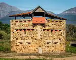 Some of the historical monuments in the Berg River Valley link the history of the area with that of the far interior of the country. This is especially true of the blockhouse on the farm Versailles just north of Welling ton railway station. It guarded the railway bridge over the Berg River and is reached from the road to Hermon. |
| 9/2/106/0004 | Dutch Reformed Church Complex, Main Street, Wellington | The cornerstone of the original church building was laid on 27 June 1838 and the building was completed in 1840.
In 1861 it was converted into a crucifix church by the addition of two wings.
The prominent tower was designed by C. Freeman and H.J. Jones.
|
Wellington | Wellington | Provincial Heritage Site | 33°38′07″S 18°59′46″E / 33.635164°S 18.996125°E |  The cornerstone of the original church building was laid on 27 June 1838 and the building was completed in 1840.
In 1861 it was converted into a crucifix church by the addition of two wings.
The prominent tower was designed by C. Freeman and H.J. Jones.
Type of site: Church Complex |
| 9/2/106/0005 | Old Market Hall, Main Street, Wellington | The cornerstone of the original church building was laid on 27 June 1838 and the building was completed in 1840.
In 1861 it was converted into a crucifix church by the addition of two wings.
The prominent tower was designed by C. Freeman and H.J. Jones.
|
Wellington | Wellington | Provincial Heritage Site | 33°38′07″S 18°59′46″E / 33.635164°S 18.996125°E | Upload Photo |
| 9/2/106/0006 | Welvanpas, Wellington District | Wellington | Wellington | National Monument | Upload Photo | ||
| 9/2/106/0007 | Bainskloof, Wellington District | Andrew Geddes Bain discovered the kloof in 1846 when the Colonial Secretary, John Montagu, was searching for a direct route through the mountains between Cape Town and the new Michell's Pass.
Montagu accepted the route for his highway and named it Bain's Kloof. Bain commenced construction work in February 1849 and the pass was opened on 12 September 1853 by the Chairman of the Central Road Board, P. B. Borcherds.
|
Wellington | Provincial Heritage Site | 33°13′40″S 21°51′25″E / 33.227792°S 21.856859°E | 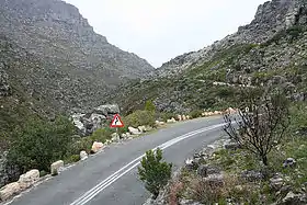 Andrew Geddes Bain discovered the kloof in 1846 when the Colonial Secretary, John Montagu, was searching for a direct route through the mountains between Cape Town and the new Michell's Pass.
Montagu accepted the route for his highway and named it Bain's Kloof. Bain commenced construction work in February 1849 and the pass was opened on 12 September 1853 by the Chairman of the Central Road Board, P. B. Borcherds.
Type of site: Pass | |
| 9/2/106/0008 | Rem. of Farm 1364, Wellington District | Wellington | Wellington | National Monument | Upload Photo | ||
| 9/2/106/0009 | WELLINGTON MUNICIPAL AREA, GENERAL | Wellington | Wellington | Upload Photo | |||
| 9/2/106/0010 | Anglo-Boer War blockhouse, Hermon, Wellington District | Hermon | Wellington | Upload Photo | |||
| 9/2/106/0011 | 20 Bain Street, Wellington | This predominantly Victorian house dates from about 1855 and originally served as the first school building in Wellington. | Wellington | Wellington | Provincial Heritage Site | 33°38′32″S 19°00′30″E / 33.642194°S 19.008257°E | 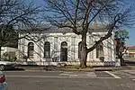 This predominantly Victorian house dates from about 1855 and originally served as the first school building in Wellington. |
| 9/2/106/0012 | Ouma Granny's House, 37 Fountain Street, Wellington | Type of site: House The property was first granted to P B Marchant in 1876.
It is now a museum. The building is an intact example of Victorian architecture of the area and houses the valuable C P Hoogenhout collection. |
Wellington | Wellington | Provincial Heritage Site | 33°38′00″S 18°59′00″E / 33.633333°S 18.983333°E | 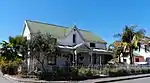 Type of site: House The property was first granted to P B Marchant in 1876.
It is now a museum.
The building is an intact example of Victorian architecture of the area and houses the valuable C P Hoogenhout collection. |
| 9/2/106/0013 | Mission Church, Bovlei, Wellington District | The road to Bovlei branches off the Bains Kloof road just beyond Wellington.
Three kilometres along this road, on the left, stands the group of buildings of the mission station known as the Dutch Reformed Mission of Wagenmakersvallei.
The building which, like other missionary churches of the time, was known as the "Gesticht" (Institute) or "Oefeninghuis", was rectangular in shape and had a thatched roof and earth floor. The two side gables were added during the 1860s and inaugurated on 21st October, 1869. This gave the building the shape of a T, the vertical stroke of the T being the original church with the gable bearing the date 1820. The thatched roof was replaced by corrugated iron in 1896 and in 1927 a wooden floor was built into the church.
Only three church buildings and only one mission church in South Africa are older than the Wagenmakersvallei Church.
The first man to do missionary work amongst the slaves and coloured people in the Wagenmakersvallei was Jan Jacob van Zulch, a convert of the well-known Cape Town minister, the Rev. Helperus Ritzema van Lier. He started this work here in 1796 and built a meeting house or "oefeninghuis" somewhere in the vicinity. In 1800 Van Zulch had to give up the work because of ill health, but it was continued by James Read, the Rev, van der Lingen and Bastiaan Tromp successively, all of them working under the aegis of the Suid-Afrikaanse Sendinggenootskap of Cape Town.
|
Wellington | Provincial Heritage Site | 33°13′40″S 21°51′25″E / 33.227792°S 21.856859°E | Upload Photo | |
| 9/2/106/0014 | Twist Niet, 31 Burg Street, Wellington | In Berg Street, almost in the heart of Wellington, stands an old Cape-Dutch T-shaped house, round which the town, as it were, originated.
In the course of time it has lost much of its glory.
The thatched roof has been replaced by one of galvanised iron and the front and back gable did not remain intact in the process.
|
Wellington | Wellington | Provincial Heritage Site | 33°38′38″S 19°00′29″E / 33.643824°S 19.008041°E | 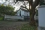 In Berg Street, almost in the heart of Wellington, stands an old Cape-Dutch T-shaped house, round which the town, as it were, originated.
In the course of time it has lost much of its glory.
The thatched roof has been replaced by one of galvanised iron and the front and back gable did not remain intact in the process.
Type of site: House. Current use: House. |
| 9/2/106/0015 | Clairvaux, Wellington | This house was from 1892 up to his death on 17 January 1917, the dwelling of the well-known theologian, Dr Andrew Murray.
Here Andrew Murray wrote many of his theological books.
|
Wellington | Wellington | Provincial Heritage Site | 33°38′00″S 18°59′00″E / 33.633333°S 18.983333°E | Upload Photo |
| 9/2/106/0016 | 34 Bain Street, Wellington | These two erven originally formed part of the farm Champagne, which was granted to the Huguenot Hercule Verdeaux in 1699.
The dwellings, one of which dates from the 1830s and the other from the 1850s, were originally in the Cape Dutch style. |
Wellington | Wellington | Provincial Heritage Site | 33°38′27″S 19°00′42″E / 33.640777°S 19.011533°E | 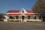 These two erven originally formed part of the farm Champagne, which was granted to the Huguenot Hercule Verdeaux in 1699.
The dwellings, one of which dates from the 1830s and the other from the 1850s, were originally in the Cape Dutch style. |
| 9/2/106/0017 | 35 Bain Street, Wellington | These two erven originally formed part of the farm Champagne, which was granted to the Huguenot Hercule Verdeaux in 1699.
The dwellings, one of which dates from the 1830s and the other from the 1850s, were originally in the Cape Dutch style. |
Wellington | Wellington | Provincial Heritage Site | 33°38′28″S 19°00′36″E / 33.641237°S 19.009906°E | 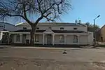 These two erven originally formed part of the farm Champagne, which was granted to the Huguenot Hercule Verdeaux in 1699.
The dwellings, one of which dates from the 1830s and the other from the 1850s, were originally in the Cape Dutch style. |
| 9/2/106/0018 | Lady Loch Bridge, Berg River, Wellington | Type of site: Bridge.
|
Wellington | Wellington | Provincial Heritage Site | 33°38′23″S 19°00′47″E / 33.639747°S 19.013004°E |  Type of site: Bridge.
Current use: Bridge. |
| 9/2/106/0019 | Victoria Jubilee Park, Church Street, Wellington | Wellington | Wellington | National Monument |  | ||
| 9/2/106/0019/001 | Coronation Arch, Victoria Jubilee Park, Church Street, Wellington | Wellington | Wellington | Provincial Heritage Site | 33°38′18″S 19°01′08″E / 33.638262°S 19.018813°E |  | |
| 9/2/106/0020 | Huguenot College Complex, Wellington | Type of site: Hostel | Wellington | Wellington | Provincial Heritage Site | 33°38′26″S 19°00′35″E / 33.640479°S 19.009656°E | 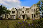 Type of site: Hostel |
| 9/2/106/0020/1 | Goodnow Hall, Huguenot College, Wellington | Wellington | Wellington | National Monument | 33°38′13″S 19°00′36″E / 33.636905°S 19.009986°E | Upload Photo | |
| 9/2/106/0020/2 | House Bliss, Huguenot College Complex, Wellington | Wellington | Wellington | 33°38′13″S 19°00′36″E / 33.636905°S 19.009986°E | Upload Photo | ||
| 9/2/106/0021 | WELLINGTON MAGISTERIAL DISTRICT, GENERAL | Wellington | Wellington | Upload Photo | |||
| 9/2/106/0022 | Slangrivier Homestead, Wellington District | Wellington | Wellington | 33°36′39″S 19°02′14″E / 33.610886°S 19.037249°E | Upload Photo | ||
| 9/2/106/0023 | "Gawie se Water", Wit River Dam, Bains Kloof, Wellington District | Bain's Kloof | Wellington | 33°32′38″S 19°10′16″E / 33.544023°S 19.171237°E | Upload Photo | ||
| 9/2/106/0024 | 53-59 Bain Street, Wellington | These six early Cape buildings from c.1830 have a history, scale and texture which is characteristic of Wellington, and they form an aesthetically pleasing group which contributes to its sensitive old town area. | Wellington | Wellington | Register | 33°38′26″S 19°00′42″E / 33.640434°S 19.011573°E | 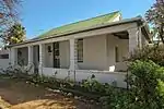 These six early Cape buildings from c.1830 have a history, scale and texture which is characteristic of Wellington, and they form an aesthetically pleasing group which contributes to its sensitive old town area. |
| 9/2/106/0025 | Welgegund 300, Wellington District | Type of site: Farm Complex. This is a mid to late 19th century building complex, which comprises a main building and three outbuildings.
The buildings are well maintained and retain much of their original joinery, architectural features and character. |
Wellington | Register | 33°13′40″S 21°51′25″E / 33.227792°S 21.856859°E | Upload Photo | |
| 9/2/112/0001 | MOORREESBURG DISTRICT, GENERAL | Moorreesburg | Moorreesburg | Upload Photo | |||
| 9/2/112/0002 | MOORREESBURG MUNICIPAL AREA, GENERAL | Moorreesburg | Moorreesburg | Upload Photo | |||
| 9/2/112/0003 | Carnegie Library, Church Street, Moorreesburg | Single storey stone Arts & Crafts style building with white plaster decoration to windows and corners.
Doric columns to porch between two forward facing wings with triangular barge-boarded gable.
Architectural style: Arts & crafts.
|
Moorreesburg | Moorreesburg | Provincial Heritage Site | 33°09′13″S 18°39′46″E / 33.153542°S 18.662844°E | 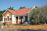 Single storey stone Arts & Crafts style building with white plaster decoration to windows and corners.
Doric columns to porch between two forward facing wings with triangular barge-boarded gable.
Architectural style: Arts & crafts.
Type of site: Library. Current use: Library. |
| 9/2/112/0004 | ACVV offices, Retief Street, Moorreesburg | Neat and substantial late Victorian school building.
This building, which was erected in 1905 by the Dutch Reformed Church at a cost of £2000.
was the first true school building in the town.
In 1906 the school opened with 209 scholars and a staff of five.
Since 1962, after the transfer of the remaining scholars to the new school, the building has been used for community functions.
|
Moorreesburg | Moorreesburg | Provincial Heritage Site | 33°09′08″S 18°39′42″E / 33.152197°S 18.661686°E | 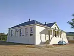 Neat and substantial late Victorian school building.
This building, which was erected in 1905 by the Dutch Reformed Church at a cost of £2000.
was the first true school building in the town.
In 1906 the school opened with 209 scholars and a staff of five.
Since 1962, after the transfer of the remaining scholars to the new school, the building has been used for community functions.
Type of site: Educational Previous use: School. Current use: Offices. |
| 9/2/112/0005 | Town Hall, Church Street, Moorreesburg | Moorreesburg | Moorreesburg | National Monument | 33°09′12″S 18°39′46″E / 33.153304°S 18.662686°E | Upload Photo | |
| 9/2/112/0006 | Railway Station, Railway Street, Moorreesburg | Moorreesburg | Moorreesburg | 33°09′08″S 18°40′13″E / 33.152205°S 18.670253°E | Upload Photo | ||
| 9/2/112/0007 | 20 Railway Street, Moorreesburg | Moorreesburg | Moorreesburg | 33°09′13″S 18°40′10″E / 33.153741°S 18.669430°E | Upload Photo | ||
| 9/2/112/0008 | Klipvlei, Moorreesburg | Moorreesburg | Moorreesburg | 33°08′47″S 18°39′58″E / 33.146309°S 18.665994°E | Upload Photo | ||
| 9/2/112/0009 | Tontelberg, Moorreesburg District | Moorreesburg | Moorreesburg | Upload Photo | |||
| 9/2/112/0010 | Eastern Terminal Beacon of Sir Thomas Maclear's Zwartland survey base line, Geelekuil 432 (Eendrag), Moorreesburg District | Type of site: Beacon. | Moorreesburg | Provincial Heritage Site | 33°14′00″S 18°30′30″E / 33.2333333333°S 18.5083333333°E | Upload Photo | |
| 9/2/112/0011 | Old School Building, Church Street, Moorreesburg | Moorreesburg | Moorreesburg | Upload Photo | |||
| 9/2/112/0012 | Tiger Oats Complex, Moorreesburg Dist | Moorreesburg | Moorreesburg | Upload Photo | |||
| 9/2/113/0001 | PRINCE EDWARD ISLAND GROUP, GENERAL | 46°37′51″S 37°56′29″E / 46.630859°S 37.941252°E | Upload Photo | ||||
| 9/2/113/0002 | MARION ISLAND, GENERAL | 46°54′13″S 37°45′50″E / 46.903521°S 37.763765°E | Upload Photo | ||||
| 9/2/113/0003 | PRINCE EDWARD ISLAND, GENERAL | 46°37′51″S 37°56′29″E / 46.630859°S 37.941252°E | Upload Photo | ||||
| 9/2/114/0001 | MITCHELLS PLAIN MAGISTERIAL DISTRICT, GENERAL | Upload Photo | |||||
| 9/2/700 | SHIPWRECKS GENERAL | Upload Photo | |||||
| HM\EDEN\MOSSEL BAY\PINNACLE POINT | Pinnacle Point | Mossel Bay | Provincial Heritage Site | 34°12′23″S 22°05′28″E / 34.206510°S 22.091110°E | Upload Photo | ||
| HM\WEST COAST\CEDERBERG\CAPE DESEADA | Baboon Point (also known as Cape Deseada) | A range of heritage resources of high significance is located on Baboon Point. The heritage significance of Baboon Point is particularly high in terms of the scientific value of archaeological and palaeontological sites that contribute to a wider understanding of southern African indigenous cultural history, local past environment and identification of original animal populations and their changes through time. Its aesthetic value also ranks high due to its almost unparalleled landmark qualities and by its role in defining important elements of the West Coast landscape character. The historical significance of Baboon Point is not only highlighted by the cultural sequence encapsulated in a number of ancient archaeological sites, but also by several World War 2 Radar station buildings. These structures are the testimony of South Africa’s role in a global historic event.
These buildings also have a particular association with important social developments in South Africa as a result of the institutionalised Apartheid system, namely their use to house migrant labourers serving the local fishing industry. The high degree of significance of Baboon Point is also supported by the presence of rare and/or endangered aspects of natural and cultural heritage. |
Elands Bay | Provincial Heritage Site | 32°19′05″S 18°19′02″E / 32.317974°S 18.317342°E | Upload Photo | |
| HM\WEST COAST\CEDERBERG\DIEP KLOOF ROCK SHELTER | Diepkloof Rock Shelter | Elands Bay | Provincial Heritage Site | 32°23′12″S 18°27′10″E / 32.386665°S 18.452776°E |  | ||
| HM\WEST COAST\CEDERBERG\MUSSEL POINT | Mussel Point (also known as Mike Taylor's Midden) | There are only a handful of shell middens along the West Coast of South Africa that are as large and deep as Mike Taylor's Midden (MTM). These very large sites, named "megamiddens", are the expression of unique social and economic (subsistence) solutions to environmental and demographic challenges that pre-colonial san hunter-gatherers had to face between 3000 and 2000 years before present (BP). MTM megamidden is at least 350m long and 200m wide and has a depth that varies between 1.0 and 1.5m. MTM dates to between 980 and 2800 BP, however, much of this occupational sequence dates to between 2100 and 2500 BP. For this reason, MTM is singular among megamiddens in that it offers the best chronological resolution (greatest volume for shortest period of time) for the later part of this unique period of the precolonial history of South Africa. | Elands Bay | Provincial Heritage Site | 32°20′12″S 18°19′03″E / 32.336591°S 18.317471°E | %252C_Elands_Bay%252C_South_Africa.jpg.webp) There are only a handful of shell middens along the West Coast of South Africa that are as large and deep as Mike Taylor's Midden (MTM). These very large sites, named "megamiddens", are the expression of unique social and economic (subsistence) solutions to environmental and demographic challenges that pre-colonial san hunter-gatherers had to face between 3000 and 2000 years before present (BP). MTM megamidden is at least 350m long and 200m wide and has a depth that varies between 1.0 and 1.5m. MTM dates to between 980 and 2800 BP, however, much of this occupational sequence dates to between 2100 and 2500 BP. For this reason, MTM is singular among megamiddens in that it offers the best chronological resolution (greatest volume for shortest period of time) for the later part of this unique period of the precolonial history of South Africa. | |
| HM\WEST COAST\CEDERBERG\VELORNEVLEI HERITAGE VILLAGE | Velorenvlei Heritage Village | Elands Bay | Provincial Heritage Site | 32°19′44″S 18°22′21″E / 32.329019°S 18.372603°E | 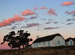 | ||
| HM\WEST COAST\MATZIKAMA\RATELGAT | Ratelgat | Vanrhynsdorp | Provincial Heritage Site | Upload Photo | |||
| HM\WEST COAST\SALDANHA BAY\PATERNOSTER MIDDEN | Pasternoster Midden | Paternoster | Provincial Heritage Site | 32°48′17″S 17°54′02″E / 32.804591°S 17.900650°E | Upload Photo | ||
| HM\WINELANDS\WITZENBERG \SARON | Saron Mission | Saron | Provincial Heritage Site | 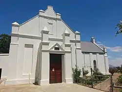 |
References
- ↑ "Western Cape Provincial Heritage Sites (previously National Monuments)" (PDF). 19 September 2002. Retrieved 28 January 2013.
- ↑ Heritage Western Cape
- ↑ "Excursion to the Sandveld (Verlorenvlei and Piketberg)" (PDF). Vernacular Architecture Society of South Africa. 29–30 September 2012. Retrieved 18 August 2022.
Lists of South African Heritage Resources | ||||||||||||||||||||
|---|---|---|---|---|---|---|---|---|---|---|---|---|---|---|---|---|---|---|---|---|
| SAHRA Heritage sites |
| Flag of South Africa | ||||||||||||||||||
| World heritage sites | ||||||||||||||||||||