Laclede's Landing | ||||||||||||||||
|---|---|---|---|---|---|---|---|---|---|---|---|---|---|---|---|---|
.jpg.webp) Laclede's Landing station platform | ||||||||||||||||
| General information | ||||||||||||||||
| Location | 200 Washington Avenue St. Louis, Missouri | |||||||||||||||
| Coordinates | 38°37′46″N 90°11′03″W / 38.629473°N 90.184108°W | |||||||||||||||
| Owned by | Bi-State Development | |||||||||||||||
| Operated by | Metro Transit | |||||||||||||||
| Platforms | 1 island platform | |||||||||||||||
| Tracks | 2 | |||||||||||||||
| Construction | ||||||||||||||||
| Structure type | Elevated | |||||||||||||||
| Bicycle facilities | Riverfront Trail | |||||||||||||||
| Accessible | Yes | |||||||||||||||
| History | ||||||||||||||||
| Opened | July 31, 1993[1] | |||||||||||||||
| Previous names | Arch Laclede's Landing | |||||||||||||||
| Passengers | ||||||||||||||||
| 2018 | 563 daily | |||||||||||||||
| Rank | 26 out of 38 | |||||||||||||||
| Services | ||||||||||||||||
| ||||||||||||||||
Laclede's Landing station is a St. Louis MetroLink station.[2] It is located near Laclede's Landing and Gateway Arch National Park in Downtown St. Louis, Missouri. The National Park Service recommends visitors accessing the Arch via public transportation use this station or the 8th & Pine station.[3]
Laclede's Landing is the easternmost station in Missouri, located on the lower deck of the Eads Bridge before crossing the Mississippi River into Illinois. The station sits at the east portal of the St. Louis Freight Tunnel, constructed in 1874 to carry trains between the Eads Bridge and the Mill Creek Valley rail yards,[4] it saw its last train (Amtrak) in 1974. The tunnel was refurbished in 1991 in preparation for the opening of MetroLink, which uses the route to connect Illinois and Missouri via downtown St. Louis.[5]
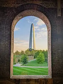
The station is known for its historic brickwork that frames the Gateway Arch from the platform level.[6]
Station layout
The station consists of a single island platform with an entrance on either end: one on Rue de L'Eglise (2nd Street) at the west end with stairs and an elevator and one on 1st Street at the east end with only stairs.
| P Platform level |
Westbound | ← Blue Line toward Shrewsbury (Convention Center) ← Red Line toward Lambert Airport (Convention Center) |
| Island platform, doors will open on the left | ||
| Eastbound | Red Line toward Shiloh–Scott (East Riverfront) → Blue Line toward Fairview Heights (East Riverfront) → | |
| G | Street level | Entrance/exit |
Public artwork
In 2013, Metro's Arts in Transit program commissioned the work Build by Beliz Brother for this station. The aluminum panels are meant to represent the drawings James Eads used to construct his namesake bridge.[7]
References
- ↑ Lindecke, Fred W. (August 1, 1993). "Area Riders Throng to Try MetroLink". The St. Louis Post-Dispatch. pp. 1A, 6A. Retrieved April 15, 2021 – via Newspapers.com.

- ↑ "Laclede's Landing Station". metrostlouis.org. Retrieved September 12, 2022.
- ↑ "Public Transportation". Gateway Arch National Park (U.S. National Park Service). Retrieved June 6, 2023.
- ↑ Primm, James, Neal (2010). Lion of the Valley, St. Louis, Missouri 1764–1980 (3rd ed.). United States: Missouri Historical Society Press. pp. 289–292. ISBN 978-1-883982-25-6.
{{cite book}}: CS1 maint: multiple names: authors list (link) - ↑ "St. Louis Freight Tunnel". Bridgehunter.com. Retrieved September 12, 2022.
- ↑ "Explore St. Louis Attractions on Laclede's Landing". Laclede's Landing Association. Retrieved September 12, 2022.
- ↑ "Build". Arts in Transit, Inc. Retrieved October 3, 2022.
External links