Klosterhäseler | |
|---|---|
Location of Klosterhäseler | |
 Klosterhäseler  Klosterhäseler | |
| Coordinates: 51°10′N 11°37′E / 51.167°N 11.617°E | |
| Country | Germany |
| State | Saxony-Anhalt |
| District | Burgenlandkreis |
| Town | An der Poststraße |
| Area | |
| • Total | 19.90 km2 (7.68 sq mi) |
| Elevation | 196 m (643 ft) |
| Population (2006-12-31) | |
| • Total | 783 |
| • Density | 39/km2 (100/sq mi) |
| Time zone | UTC+01:00 (CET) |
| • Summer (DST) | UTC+02:00 (CEST) |
| Postal codes | 06647 |
| Dialling codes | 034463, 034465, 034467 |
Klosterhäseler is a village and a former municipality in the Burgenlandkreis district, in Saxony-Anhalt, Germany. Since 1 July 2009, it is part of the municipality An der Poststraße.
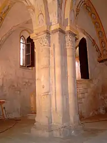
Central column of the crypt of the former Cistercian nunnery in Klosterhäseler
This article is issued from Wikipedia. The text is licensed under Creative Commons - Attribution - Sharealike. Additional terms may apply for the media files.